Acton, London
| Acton | |
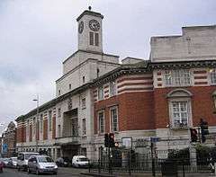 Acton Town Hall, built for Acton Urban District and opened 10 March 1910 |
|
 Acton |
|
| Area | 9.20 km2 (3.55 sq mi) |
|---|---|
| Population | 62,480 [1] |
| – density | 6,791/km2 (17,590/sq mi) |
| OS grid reference | TQ205805 |
| – Charing Cross | 6.1 mi (9.8 km) W |
| London borough | Ealing |
| Ceremonial county | Greater London |
| Region | London |
| Country | England |
| Sovereign state | United Kingdom |
| Post town | LONDON |
| Postcode district | W3,W4,W12 |
| Postcode district | NW10 |
| Dialling code | 020 |
| Police | Metropolitan |
| Fire | London |
| Ambulance | London |
| EU Parliament | London |
| UK Parliament | Ealing Central and Acton |
| London Assembly | Ealing and Hillingdon |
Coordinates: 51°30′49″N 0°16′14″W / 51.513519°N 0.270661°W
Acton (/ˈæktən/) is a large area within the London Borough of Ealing in west London, England, 6.1 miles (10 km) west of Charing Cross.
At the 2011 census, its four wards, East Acton, Acton Central, South Acton and Southfield, had a population of 62,480, a ten-year increase of 8,791 people.[2] North Acton, West Acton, East Acton, South Acton, Acton Green, Acton Town, Acton Vale and Acton Central are all parts of Acton.
Acton means "oak farm" or "farm by oak trees", and is derived from the Old English āc (oak) and tūn (farm).[3][4] Originally an ancient village, as London expanded, Acton became absorbed into the city. Since 1965, Acton equates to the east of the London Borough of Ealing, though some of East Acton is in the London Borough of Hammersmith and Fulham and a small portion of South Acton is in the London Borough of Hounslow. Acton and Harrow are the two locations with the most stations bearing their name anywhere in the United Kingdom (apart from the full names of the London terminus stations), with seven each.
Central Acton is synonymous with the hub of commerce and retail on the former main road between London and Oxford (the Uxbridge Road); a reminder of its history is in its inns, which date back in cases to the late Tudor period as stopping places for travellers. Nowadays, the principal route linking London and Oxford (the A40 dual carriageway) bypasses central Acton, but passes through East Acton and North Acton.
Toponymy
Acton's name derives from the Old English words āc (oak) and tūn (farm), meaning "oak farm" or "farm by oak trees". For several centuries, its name bore the prefix Church (hence Chirche Acton, Churche Acton, etc.) to distinguish it from the separate hamlet of East Acton.[3]
History

Prehistoric settlement is shown by finds of Palaeolithic, Neolithic, and Bronze Age burials at Mill Hill Park, and Iron Age coins near Bollo Lane. In the Middle Ages the northern half of the parish was heavily wooded. Oaks and elms still stood along roads and hedgerows and in private grounds in the early 20th century, but most of the woodland had been cleared by the 17th century, even on the extensive Old Oak common.[4]
Landholders figuring in county records were resident by 1222 and houses were recorded from the late 13th century. The main settlement, Church Acton or Acton town, lay slightly west of the centre of the parish along the highway to Oxford (Uxbridge Road) at the 5-mile post out of London. By 1380 some of the tenements, such as The Tabard and The Cock, along the south side of the road, were inns. The hamlet of East Acton, mentioned in 1294, consisted of farmhouses and cottages north and south of common land known as East Acton green by 1474.[4]
Medieval settlement was mainly around the two hamlets. At Church Acton most of the farmhouses lay along the Oxford road or Horn Lane, with only a few outlying farms. Friars Place Farm at the north end of Horn Lane and the moated site to the west, occupied until the 15th century, were early farms. East of Friars Place farm were commons: Worton or Watton Green and Rush green in the 16th and 17th centuries, and Friars Place in the 18th century, where there was some settlement by 1664. To the north-west were Acton or Old Oak wells, known by 1613. In the extreme south part of the parish a few farmhouses on the northern side of Acton common or Acton Green were mentioned as in Turnham Green until the 19th century and were linked more closely with that village than with Acton. Gregories, mentioned in 1551 as a copyhold tenement with 30 a. near Bollo Lane and the Brentford high road, probably lay in Acton.[4]
Londoners were increasingly involved in land sales from the early 14th century but apparently did not live in Acton until the late 15th. The manor, part of Fulham, had no resident (demesne) lord, and apart from a brief period before c. 1735, when a branch of the landed Somerset (Duke of Beaufort's) family lived in Acton, there were no large resident landowners. Many of the tenements without land, including most of the inns, frequently changed hands.[4]
By the 17th century Acton's proximity to London had made it a summer retreat for courtiers and lawyers. Sir Richard Sutton bought the seat at East Acton known later as Manor House in 1610 and Sir Henry Garraway probably rebuilt Acton House in 1638. Sir John Trevor MP bought several Acton properties in the mid 17th century, including Berrymead/Berrymede, improving it with a lake and stream, home of George Savile, 1st Marquess of Halifax and his second son after him, and afterwards of the Duke of Kingston-upon-Hull, with a much-praised landscape.[4]
The parish had 158 communicants in 1548. In 1664 it had 72 chargeable households and 59 exempt, with 6 empty houses. Six houses had 10 or more hearths, 16 had from 5 to 9, 33 had 3 or 4, 23 had 2, and 53 had 1. Action had about 160 families resident in the mid 18th century.[4]
Acton was lauded as "blessed with very sweet air" in 1706 by rector urging a friend in verse to move there. The fashion for medicinal waters brought a brief period of fame, with the exploitation of the wells at Old Oak common, when East Acton and Friars Place were said to be thronged with summer visitors, who had brought about improvement in the houses there. Although high society had left Acton by the mid 18th century, many professional and military men bought houses there, sometimes including a small park, until well into the 19th century. The break-up of the 800 acres (3.2 km2) Fetherstonhaugh estate, which had had no resident owner, produced four or five small estates whose owners, professional men such as Samuel Wegg, John Winter, and Richard White, were active in parish affairs. Grand early homes included: Heathfield Lodge, West Lodge, and East Lodge by Winter c. 1800, Mill Hill House by White, and Woodlands at Acton Hill soon afterwards. Acton Green also became increasingly popular, being near Chiswick High Road (the Great West Road). Fairlawn, substantial, on west side of the green, was the home of the botanist John Lindley (1797–1865) as was the house to the north and Bedford House, another home of Lindley, and Melbourne House further east. A short row of houses had been built on the south side of the green by 1800.[4]
There were 241 inhabited houses in 1801 and 426 by 1831. Growth took place mainly in the established residential neighbourhoods of Acton town and East Acton, but Acton Green also had acquired a cluster of cottages and houses at the bottom of Acton Lane by 1842. Acton was mostly rural in 1831. The few mansions contrasted sharply with most of the houses, which were described as 'beneath mediocrity of character'. Despite an overall rise in the number of houses, poor rates had to be increased in the 1820s because of a growing number of empty dwellings.[4]
More widespread building was planned and took place in the 1850s. As a result of its soft water sources, Acton became famous for its laundries and at the end of the 19th century there were around 170 establishments in South Acton. These laundries would serve hotels and the rich in London's West End, leading to the nickname "Soapsuds Island" or "Soap Sud City". At least 600 different laundries operated within South Acton; the last laundry closed in the late 1970s and is now a low redbrick block of flats.[5]
The parish of Acton formed a local board of health in 1865 and became an urban district in 1894. The town was incorporated as the Municipal Borough of Acton in 1921. This authority combined with the municipal boroughs of Ealing and Southall to form the London Borough of Ealing, within Greater London, in 1965.[4] An Acton Golf Club was founded in 1896, which closed in 1920 and the area was redeveloped for housing.[6]
Development
Acton formed an urban district and, later, municipal borough of Middlesex from 1894 to 1965. Its former area was used to form part of the London Borough of Ealing in 1965. During the 20th century Acton was a major industrial centre employing tens of thousands of people, particularly in the motor vehicles and components industries. The industries of North Acton merged with the great industrial concentrations of Park Royal and Harlesden. One of the most important firms was Renault of France, which made cars, including the 4CV and the Renault Dauphine, at a factory in North Acton from 1926 until 1960.[7] Renault has remained on the site continuously since the 1920s and still has its main London showroom on the Park Royal site.
Further south Acton Vale had famous names including D. Napier & Son (engines), H. Bronnley & Co (Soaps), Evershed & Vignoles (electrical equipment), Lucas CAV (automotive electrical), Vandervell Products (bearings), and Wilkinson Sword (swords and razors). Acton is now principally residential, though it maintains some light industry, particularly in the northeast Park Royal area, and the south near the border with Chiswick. Waitrose started in Acton, as Waite, Rose and Taylor - on the High Street near the police station - with its second branch opening in Churchfield Road in 1913.[8]
Acton is home to the largest housing estate in West London, the South Acton estate, with approximately 2,000 homes and 5,800 residents.[9]
This area is currently in the Phase 2 of a major 15-year phased regeneration which includes near-total demolition of the existing residential units, and the construction of new and more numerous residential units. Since World War II, Acton has had a small but notable population of Polish immigrants. In recent years, a number of Antipodean immigrants have settled there; there are several Australian and South African pubs concentrated in a small area. A Japanese school has also attracted a Japanese community to West Acton. The Somali community is concentrated around Church Road, and there are two mosques near the High Street. The Irish community has diminished somewhat in recent years, but there are still a number of Irish pubs in the area.
Acton will host the starting point of the 25 kilometre Thames Tideway Tunnel (also known as the "Super Sewer") at the Acton Storm Tanks[10] in Canham Road. This will be built to avoid the discharge of sewage from Combined Sewer Overflow into the River Thames.[11]
Leisure
The Acton High Street has a range of pubs which vary in theme and clientele.
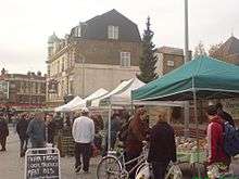
The recently refurbished 'Mount' on Acton High Street hosts a Market on Thursday, Friday and Saturday. Visitors can shop at stalls selling a range of produce. Acton's library, swimming baths (built in 1904) and Town Hall are examples of tall Victorian municipal buildings that can be found along the High Street. Acton Swimming Baths closed in December 2011 for a three-year development project, replacing the existing pools with a 25m 8-lane pool and a smaller teaching pool. The site reopened in April 2014[12]
On the east end of Acton High Street is Acton Park, which features bowls facilities, a children’s play area, tennis courts, a basket/football court, a pond and an art block. There is a cafe next to the bowling green selling meals as well as tea/coffee and cakes and ice cream.
Education

Secondary schools
Acton has three state-funded secondary high schools, Acton High School, Twyford Church of England High School and The Ellen Wilkinson School for Girls, and an independent school, the Barbara Speake Stage School. Acton was once home to another independent school, Haberdashers' Aske's School for Girls before it changed its site to Elstree, the Acton site becoming the Cardinal Newman Roman Catholic High School. Acton also hosts the King Fahad Academy, an independent Muslim school.
International schools
The Japanese School in London is in Acton.[13]
Acton in popular culture
- The 1971 film Villain starring Richard Burton and Ian McShane clearly features Acton Central railway station in one of its sequences. Similarly another sequence in the same film shows the characters Danny and Inspector Matthews talking while on a train which they caught at Acton
- Episode 1 of How the Other Half Lives, a Channel 4 documentary, shows the poverty of one family on the South Acton estate compared to living in the wealthy part of the country.
- Acton was the birthplace of The Who, of which all members except Keith Moon went to Acton High School (then named Acton County Grammar School).
- Pete Townshend's 1982 solo album, All the Best Cowboys Have Chinese Eyes, contained the track "Stardom in Acton" in reference to his home town, while the accompanying video was filmed on and around Acton High Street.
- In the episode of Alan Partridge Towering Alan, the character Mike Sampson is from Acton. He is a socially inept character who describes Acton as having "a few too many blacks."
- An episode of Chris Morris's spoof news program The Day Today featured a segment called 'The Pool', a documentary about "St. Lamb's Pool in Acton". The scene was shot in the Acton Swimming Baths.
- The Monty Python sketch 'Bicycle Repair Man' was shot on Churchfield Road; part of the sketch 'Hell's Grannies' was shot on Acton High Street.
- The English indiepop act The Hit Parade mentions Acton in their song Henry from 1993.
- Leo Sayer's 1983 single Orchard Road in reality refers to Acton's Churchfield Road.[14]
- In the TV series Minder, Arthur Daley's car lot was by the railway bridge in The Vale[15] with the door of the Winchester Club in Newburgh Road[16] off Churchfield Road. The lock up was on the Bush Industrial Estate.[17] Minder locations in Acton featured throughout series 7 to 10.
- Acton Park often hosted filming for programmes such as Rose & Macaulay and The Deal. Other parts of Acton were used for The Sweeney and early episodes of The Bill.
- The first Waitrose store in the UK was in Acton. Originally called "Waite, Rose and Taylor", it opened in 1904, at number 263 Acton Hill. A metal plate commemorating this has been inserted into the pavement outside these premises as it was not possible to obtain permission from the current owners of the building to affix a plaque onto it.
- Scenes from the 1986 movie Aliens and the 1989 movie Batman were shot inside the disused Acton Lane Power Station.
- The Ken Loach film Ladybird Ladybird was filmed at many sites around Acton including The Mount, the Town Hall, Vyner Road, Cumberland Park and parts of South Acton.
- The band Art of Noise featured a track entitled "Acton Art" as a B-Side to their 12" Single release of "Dragnet".
- Joe Strummer and the Mescaleros played a gig in support of striking firefighters on 15 November 2002 at Acton Old Town Hall, and Mick Jones joined Strummer on stage, marking the first time they performed together since Jones's departure from The Clash.
- 1970s footballer Robin Friday who played for Reading and Cardiff City was born in Acton.
- The family terraced home in which Jimmy Cooper, the lead character in The Who's film version of Quadrophenia lived, was in Wells House Road, Acton. When left derelict, the house was stripped of fixtures and fittings by devotees of the cult movie.
- Playwright/Composer Lionel Bart lived the latter part of his life in an apartment on Churchfield Road, citing the area as the closest thing he could find to the community feel of the east London "of old".
- Sandra and Samantha Lawrence The Wee Papa Girl Rappers were a British female rap duo, who came from Acton & lived in one of the tower blocks next to Acton Police Station, the picture on the back cover of their album was taken out side their block.
- Writer John Muckle's novel of motorcycle despatch riders 'London Brakes'(2010) is partly set and was largely written in Moreton Tower, Acton, in the 1980s.
- "My Street" an award-winning documentary by director Sue Bourne was made in Goldsmith Avenue, Acton and featured twelve households there. Soon after transmission Abu Qatada's family moved into one of the featured houses and he spent some months out on bail living in the house.
- The film Frequently Asked Questions About Time Travel (2009) was partly set in the Talbot pub on Mill Hill road, Acton.
- Many scenes of TV series Silent Witness are filmed around Acton and Park Royal. Silent Witness's production offices and sets are at BBC Park Western in North Acton.
Transport
Tube/Rail
Stations in the area are:
- Acton Central railway station (North London Line)
- Acton Main Line railway station (First Great Western)
- Acton Town tube station (District line and Piccadilly line)
- East Acton tube station (Central line)
- North Acton tube station (Central line)
- South Acton railway station (North London Line, and formerly District line)
- West Acton tube station (Central line (Ealing Broadway branch))
- Acton Green tube station (now Chiswick Park, District line)
Acton and Harrow are the only two places in the United Kingdom each to have seven railway stations bearing their names, other than London itself. Acton is also the only place in London to have stations named after all four of the cardinal points, north, south, east, and west.[18] The widespread provision of train services reflects a long railway history, particularly associated (historically) with London Transport and the Great Western Railway.
North Acton has a large Great Western Railway housing estate (now privately owned),[19] and the Old Oak Common TMD railway depot is within the usual boundary, as is the London Transport Museum Depot which houses an extensive collection of historic and heritage rolling stock. Acton Main Line station has a busy freight yard (operating ballast and container trains).
Buses
London Buses routes 7, 70, 72, 94, 95, 207, 228, 260, 266, 272, 283, 427, 440, 487, 607, E3, N7, N11 and N207 serve Acton.[20][21]
Shelved tram proposals
Transport for London, led by then Mayor of London, Ken Livingstone, proposed to build a West London Tram between Shepherd's Bush and Uxbridge town centre.[22] It would have run along the A4020, the Uxbridge Road, through Acton, Ealing, West Ealing, Hanwell, Southall and Hayes End. This proposed scheme was highly controversial and resulted in strong differences in opinion between TfL, who supported the scheme, and local councils throughout the proposed route, who all took a 'no tram' stance.[23]
The West London Tram was finally scrapped when former Prime Minister Gordon Brown agreed that the long-awaited Crossrail would go ahead in October 2007. Acton Main Line railway station is to be part of the Crossrail network once it is completed, with 4 trains an hour servicing each route.[24]
Neighbouring places
Gallery
-
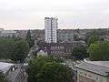
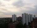
View of South Acton from Barwick House, showing Jerome Tower and Berrymede Junior School
-

Acton Park
-
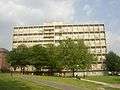
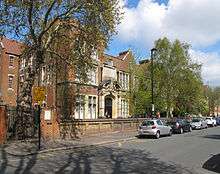
Barwick House, on the South Acton estate
-
Blocks of flats on the South Acton estate
References
- ↑ Key Statistics; Quick Statistics: Population Density United Kingdom Census 2011 Office for National Statistics Retrieved 31 October 2014
- ↑ "Key Statistics; Quick Statistics: Population Density". United Kingdom Census 2011. Office for National Statistics. Retrieved 31 October 2014.
- 1 2 Mills, A.D. (2010). A Dictionary of London Place-Names. Oxford University Press. p. 2. ISBN 9780199566785.
- 1 2 3 4 5 6 7 8 9 10 T F T Baker, C R Elrington (editors), Diane K Bolton, Patricia E C Croot, M A Hicks (1982). "Acton: Growth". A History of the County of Middlesex: Volume 7: Acton, Chiswick, Ealing and Brentford, West Twyford, Willesden. Institute of Historical Research. Retrieved 5 November 2014.
- ↑ Laundry details and number of sites, actonhistory.co.uk; accessed 14 January 2016.
- ↑ "Acton Golf Club, London", "Golf’s Missing Links".
- ↑ "London's Lost Manufacturing - We Were Once The British Detroit". Londonist. Retrieved 16 January 2016.
- ↑ Waitrose: seeking to attain perfection by Janet Appleyard-Hobbs 2009 Acton History Society
- ↑ "South Acton Residents Action Group". Sarag.org. Retrieved 28 July 2013.
- ↑ http://www.thameswater.co.uk/about-us/18037.htm
- ↑ "Thames Tunnel | Creating a cleaner, healthier River Thames". Thamestunnelconsultation.co.uk. 27 March 2013. Retrieved 28 July 2013.
- ↑ Everyone Active Acton Centre, ealing.gov.uk; 19 April 2014; accessed 14 January 2016.
- ↑ Profile, thejapaneseschool.ltd.uk; retrieved 1 January 2014.
- ↑ The Bob Rogers Show, Radio 2CH, 10:31:30 AEST 31 July 2008.
- ↑ Staff (1 February 2013). "Minder Locations". Minder.org. Retrieved 28 July 2013.
- ↑ Staff (1 February 2013). "Minder Locations". minder.org. Retrieved 28 July 2013.
- ↑ Staff (24 July 2013). "Minder Locations". Minder.org. Retrieved 28 July 2013.
- ↑ See details at London Postcode Walks.
- ↑ See section "The Railway Expansion" at Acton History website.
- ↑ Central Acton bus routes.
- ↑ East Acton bus routes.
- ↑ "Mayor says yes to new trams and busways". Mayor of London/Greater London Authority. 29 May 2002. Archived from the original on 18 April 2003. Retrieved 15 January 2016.
- ↑ "Majority say 'no' to tram scheme". BBC News. 1 March 2005. Retrieved 15 January 2016.
- ↑ "West London Tram". Transport for London (archived page). 10 April 2008. Archived from the original on 10 April 2008. Retrieved 15 January 2016.
External links
| Wikimedia Commons has media related to Acton, London. |
- British History Online - Acton
- ActonW3.com - a digital local newspaper for the area
| Districts |  | |
|---|---|---|
| Attractions | ||
| Parks and open spaces |
| |
| Constituencies | ||
| Tube and railway stations |
| |
| Other topics | ||