Longzhou County
| Longzhou County 龙州县 · Lungzcouh Yen | |
|---|---|
| County | |
|
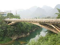
Typical scene in the county, taken in July in Shangjin Township with the Zuo River in the background | |
| Coordinates: 22°20′42″N 106°51′15″E / 22.34500°N 106.85417°ECoordinates: 22°20′42″N 106°51′15″E / 22.34500°N 106.85417°E | |
| Country | People's Republic of China |
| Region | Guangxi |
| Prefecture-level city | Chongzuo |
| Area | |
| • Total | 2,317.8 km2 (894.9 sq mi) |
| Time zone | China Standard (UTC+8) |

Longzhou County (Chinese: t 龍州縣, s 龙州县, p Lóngzhōu Xiàn, w Lung-chou Hsien; Zhuang: Lungzcouh Yen) is a county of southwestern Guangxi, China, bordering Cao Bằng province, Vietnam. It is under the jurisdiction of the prefecture-level city of Chongzuo.
Longzhou lies in a circular valley at the junction of the Xun and Guijiang rivers.
Geography
Longzhou has a monsoon-influenced humid subtropical climate (Köppen Cwa), with short, mild winters, and long, very hot and humid summers. Winter begins dry but becomes progressively wetter and cloudier. Spring is generally overcast and often rainy, while summer continues to be rainy though is the sunniest time of year. Autumn is sunny and dry. The monthly 24-hour average temperature ranges from 14.0 °C (57.2 °F) in January to 28.2 °C (82.8 °F) in July, and the annual mean is 22.21 °C (72.0 °F). The annual rainfall is just above 1,300 mm (51 in), a majority of which is delivered from June to August. With monthly percent possible sunshine ranging from 16% in February and March to 50% in September, the county receives 1,583 hours of bright sunshine annually.
Divisions
Towns: Longzhou:(龙州镇), Xiadong(下冻镇), Shuikou(水口镇), Jinlong(金龙镇),Xiangshui(响水镇) Townships: Bajiao(八角乡),Shangjiang(上降乡),Binqiao(彬桥乡),Shanglong(上龙乡),Wude(武德乡),Zhubu(逐卜乡),Shangjin(上金乡)
| Climate data for Longzhou County (1971–2000) | |||||||||||||
|---|---|---|---|---|---|---|---|---|---|---|---|---|---|
| Month | Jan | Feb | Mar | Apr | May | Jun | Jul | Aug | Sep | Oct | Nov | Dec | Year |
| Average high °C (°F) | 18.3 (64.9) |
19.5 (67.1) |
23.0 (73.4) |
27.7 (81.9) |
31.6 (88.9) |
33.0 (91.4) |
33.4 (92.1) |
33.0 (91.4) |
31.8 (89.2) |
28.8 (83.8) |
24.8 (76.6) |
21.4 (70.5) |
27.2 (80.9) |
| Average low °C (°F) | 11.1 (52) |
12.8 (55) |
16.2 (61.2) |
20.3 (68.5) |
23.1 (73.6) |
24.7 (76.5) |
24.9 (76.8) |
24.6 (76.3) |
23.1 (73.6) |
19.8 (67.6) |
15.5 (59.9) |
11.7 (53.1) |
19.0 (66.2) |
| Average rainfall mm (inches) | 33.4 (1.315) |
33.0 (1.299) |
53.3 (2.098) |
86.7 (3.413) |
184.5 (7.264) |
217.8 (8.575) |
221.5 (8.72) |
216.6 (8.528) |
121.7 (4.791) |
77.7 (3.059) |
38.1 (1.5) |
19.8 (0.78) |
1,304.1 (51.342) |
| Average rainy days (≥ 0.1 mm) | 11.3 | 11.7 | 14.3 | 13.8 | 15.2 | 16.9 | 18.0 | 17.1 | 12.3 | 10.9 | 6.9 | 5.9 | 154.3 |
| Average relative humidity (%) | 79 | 80 | 80 | 80 | 79 | 82 | 83 | 84 | 82 | 80 | 78 | 76 | 80.3 |
| Mean monthly sunshine hours | 65.7 | 51.9 | 58.2 | 91.8 | 162.8 | 171.7 | 198.0 | 188.5 | 181.7 | 158.3 | 135.9 | 118.2 | 1,582.7 |
| Percent possible sunshine | 20 | 16 | 16 | 24 | 40 | 43 | 48 | 47 | 50 | 44 | 41 | 36 | 35.4 |
| Source: China Meteorological Administration | |||||||||||||