Lower Longley
| Lower Longley Hobart, Tasmania | |||||||||||||
|---|---|---|---|---|---|---|---|---|---|---|---|---|---|
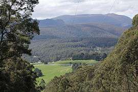 The highest point of the Huon Highway at Vinces Saddle in Lower Longley | |||||||||||||
| Postcode(s) | 7109 | ||||||||||||
| LGA(s) | Huon Valley, Kingborough. | ||||||||||||
| Federal Division(s) | Franklin | ||||||||||||
| |||||||||||||
Lower Longley is a rural locality situated on the borders of the Kingborough and Huon Valley local government areas, which straddles the Huon Highway and is made up primarily of acreage properties. Lower Longley had 131 inhabitants as of the 2011 Australian Census.[1] Despite being called Lower Longley, the suburb is physically higher than neighbouring Longley.
History
The Lower Longley State School was opened some time before 1900, before being replaced by a newer school in 1941 after complaints of the conditions at the school being "disgraceful"[2][3] The school closed at some point.
Lower Longley has had numerous churches in its history, including a Wesleyan church opened 1890[4] however the last church in Lower Longley was burnt down in the 1967 fires and relocated afterwards to Sandfly to become St. Lukes.
In 1898 the township of Lower Longley was mostly destroyed in a severe fire[5]
Lower Longley includes a town hall[6] — the original of which was opened in 1907[7] by the Premier of Tasmania and later replaced after the 1967 bushfires which destroyed the original building. There remains an early 20th-century Methodist cemetery, orphaned following the loss of its church in the same fire.[8][9]
References
- ↑ "2011 Census QuickStats: Lower Longley". Censusdata.abs.gov.au. Retrieved 2013-08-05.
- ↑ "21 Jun 1939 - LOWER LONGLEY SCHOOL Proposed Removal". Trove.nla.gov.au. 1939-06-21. Retrieved 2013-08-05.
- ↑ "06 May 1941 - The Huon NEW SCHOOL AT LONGLEY Opening Ceremony". Trove.nla.gov.au. 1941-05-06. Retrieved 2013-08-05.
- ↑ "29 Oct 1890 - OPENING OF NEW WESLEYAN CHURCH, LOWER LONGLEY. [". Trove.nla.gov.au. Retrieved 2013-08-05.
- ↑ "03 Jan 1898 - THE BUSH FIRES. LONGLEY AND SANDELY IN ASHES. SE". Trove.nla.gov.au. Retrieved 2013-08-05.
- ↑ "Kingborough Council - Council Venues for Hire - Tasmania". Kingborough.tas.gov.au. Retrieved 2013-08-05.
- ↑ "25 Mar 1907 - LOWER LONGLEY. PREMIER OPENS NEW PUBLICHALL". Trove.nla.gov.au. 1907-03-25. Retrieved 2013-08-05.
- ↑ "Tasmania -Lower Longley Methodist Headstones". Australian Cemeteries. Retrieved 2013-08-05.
- ↑ "Kingborough Council - Cemeteries in Kingborough - Tasmania". Kingborough.tas.gov.au. Retrieved 2013-08-05.
Coordinates: 42°58′39″S 147°08′29″E / 42.97750°S 147.14139°E