Ludlow Village Historic District (Ludlow, Massachusetts)
|
Ludlow Village Historic District | |
|
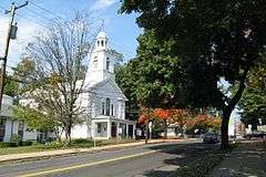
United Church of Christ | |
  | |
| Location | Ludlow, Massachusetts |
|---|---|
| Coordinates | 42°9′55″N 72°26′32″W / 42.16528°N 72.44222°WCoordinates: 42°9′55″N 72°26′32″W / 42.16528°N 72.44222°W |
| Architect | Multiple |
| Architectural style | Colonial Revival, Queen Anne, Romanesque |
| NRHP Reference # | 93000009[1] |
| Added to NRHP | February 22, 1993 |
The Ludlow Village Historic District encompasses a historic mill village, and the economic center of the town of Ludlow, Massachusetts beginning in the later years of the 19th century.[2] The area started to take over from Ludlow Center as the center of economic importance with the arrival of jute mills on the Chicopee River.[3] The district is roughly bounded by Winsor, Sewall and State Sts. and the Chicopee River. It was listed on the National Register of Historic Places (NRHP) in 1993.[1]
See also
References
- 1 2 National Park Service (2008-04-15). "National Register Information System". National Register of Historic Places. National Park Service.
- ↑ "MACRIS inventory record for Ludlow Business District". Commonwealth of Massachusetts. Retrieved 2013-12-12.
- ↑ "MACRIS inventory record for Ludlow Center Historic District". Commonwealth of Massachusetts. Retrieved 2013-12-12.
| Topics |  | ||||||||||||||||||||||||||||||
|---|---|---|---|---|---|---|---|---|---|---|---|---|---|---|---|---|---|---|---|---|---|---|---|---|---|---|---|---|---|---|---|
| Lists by county | |||||||||||||||||||||||||||||||
| Lists by city |
| ||||||||||||||||||||||||||||||
| Other lists | |||||||||||||||||||||||||||||||
| |||||||||||||||||||||||||||||||
This article is issued from Wikipedia - version of the 11/27/2016. The text is available under the Creative Commons Attribution/Share Alike but additional terms may apply for the media files.