M48 motorway
| |
|---|---|
|
The Severn Bridge is the most prominent landmark on the M48. | |
| Route information | |
| Maintained by Highways England and the South Wales Trunk Road Agency | |
| Length: | 12 mi (19 km) |
| Existed: | 1966 – present |
| Major junctions | |
| East end: | Awkley |
|
J21 → M4 motorway J23 → M4 motorway | |
| West end: | Undy |
| Location | |
| Primary destinations: | Chepstow |
| Road network | |

_full_view_-_geograph.org.uk_-_1742850.jpg)
The M48 is a 12-mile (19 km) long motorway in Great Britain, which connects Gloucestershire, England, and Monmouthshire, Wales, via the original Severn Bridge. The M48 is anomalously numbered, as it is entirely to the west of the M5 motorway thus falling into zone 5 of the motorway numbering system.[1][2] It is one of only three motorways in Wales.
Route
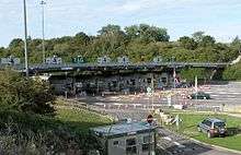
Travelling from east to west, after leaving the M4 at Awkley, Junction 21, near Olveston in England, the M48 begins by heading north-west towards Aust, Junction 1. It then passes through a toll booth for westbound traffic only, and crosses the Severn and Wye rivers via their respective bridges. Entering Wales, the M48 heads south-west after Junction 2, passing to the south of Chepstow, past Crick and continuing in a south westerly direction, passing Caldicot and Rogiet. The motorway rejoins the M4 at Undy, Junction 23 to the east of Magor.
Junction 2 can be reached via the A466, which leads to the A48. The junction gives access to the Wye Valley, an Area of Outstanding Natural Beauty. When travelling either east or west on the M4, the M48 is the most direct route for Chepstow and Caldicot.
History

The M48 was opened as part of the M4 in 1966.[3] Before this date traffic between South West England and South Wales was either transported on a motorail service through the Severn Tunnel, used the Aust Ferry (which was unsuitable for large goods vehicles) or travelled through Gloucester to pass north of the Severn Estuary.[4]
After opening, the route became increasingly busy, and in 1984 a report was commissioned into a Second Severn Crossing.[5] After four years of construction this new route was opened in 1996 and the M4 was diverted over the newer bridge.[3] The original stretch of motorway was renumbered as M48 and now shares the traffic between England and Wales.
Services
Junction 1 is the location of Severn View services (formerly called Aust Services when originally opened for the M4 motorway), which can also be accessed by the A403, from Avonmouth. There is a footpath leading from the service station to allow pedestrians to cross the bridge.
When the M4 was diverted over the Second Severn Crossing, it was anticipated that these services may close. However, although the original building – which had offered views of the River Severn – was sold, due to business falling as a consequence of traffic using the newer bridge, operations continued in a new, much smaller development on an adjacent site nearer the motorway junction.[6]
Junctions
Data from driver location signs are used to provide distance and carriageway identifier information.[7] Where a junction spans several hundred metres and start and end points are available, both are cited.
| M48 motorway | |||||
| mile | km | Eastbound exits (B carriageway) | Junction | Westbound exits (A carriageway) | |
|---|---|---|---|---|---|
| 117.6 | 189.3 | London, Bristol M4 | M4 J21 Terminus |
Chepstow, Services M48 Start of motorway | |
| 120.5 | 193.9 | Avonmouth A403, Services | J1 Services |
Avonmouth A403, Services | |
| 120.8 | 194.4 | No tolls | Tolls | Toll booth | |
| 121.1 122.8 |
194.9 197.6 |
Severn Bridge Entry into England Wye Bridge |
River Severn Border River Wye |
Severn Bridge Entry into Wales Wye Bridge | |
| 123.2 123.4 |
198.2 198.6 |
Chepstow A466 (A48) Cas – gwent |
J2 | Chepstow A466 (A48) Cas – gwent | |
| 130.2 | 209.6 | Start of motorway Chepstow, Services M48 Cas – gwent, Gwasanaethau |
Terminus M4 J23 |
Newport, Cardiff M4 Casnewydd, Caerdydd | |
Notes
| |||||
| 1.000 mi = 1.609 km; 1.000 km = 0.621 mi | |||||
Information above gathered from Advanced Direction Signs May 2011
See also
References
- ↑ "Motorway Database – M48". CBRD. Retrieved 26 October 2007.
- ↑ Steven Jukes. "Pathetic Motorways". Pathetic.org.uk. Retrieved 28 November 2012.
- 1 2 "Severn Crossing Dates". The Motorway Archive. Retrieved 26 October 2007.
- ↑ "Severn Crossing". The Motorway Archive. Retrieved 26 October 2007.
- ↑ "Second Severn Crossing". The Motorway Archive. Retrieved 26 October 2007.
- ↑ "Aust / Severn View Services". Motorway Service Area Triva site. Retrieved 18 April 2008.
- ↑ Traffic England Live Traffic Condition Map Highways Agency – Locations extracted from Traffic Camera Popup identifier text
External links
| Great Britain | .svg.png) | |||||||
|---|---|---|---|---|---|---|---|---|
| Northern Ireland | ||||||||
| Former | ||||||||
| Unbuilt | ||||||||
| Proposed | ||||||||
| Related articles | ||||||||
| ||||||||
Trunk Roads in Wales | ||
|---|---|---|
| Managed by the North and Mid Wales Trunk Road Agent |
|  |
| Managed by the South Wales Trunk Road Agent |
| |
| Related topics and further information | ||
