Maham
| Meham महम Maham | |
|---|---|
| Town, small city | |
 Meham  Meham Location in Haryana, India | |
| Coordinates: 28°59′N 76°18′E / 28.98°N 76.3°ECoordinates: 28°59′N 76°18′E / 28.98°N 76.3°E | |
| Country |
|
| State | Haryana |
| District | Rohtak |
| Elevation | 214 m (702 ft) |
| Population (2001) | |
| • Total | 18,166 |
| Languages | |
| • Official | Hindi ,Regional Haryanvi |
| Time zone | IST (UTC+5:30) |
| Vehicle registration | HR 15 |
| Website |
haryana |
Meham is a small city, sub-division, tehsil and a municipal committee in Rohtak district in the Indian state of Haryana. The Haryana govt has shown interest in building a Greenfield Cargo Airport at this city to serve the city of Rohtak. AAI has given in-principle consent to this plan in Jan 2014. Meham is one of the two sub-divisions in Rohtak district. Meham tehsil is further divided into two community development blocks, Meham and Lakhan-Majra.
Geography
Maham is located at 28°59′N 76°18′E / 28.98°N 76.3°E.[1] It has an average elevation of 214 metres (702 feet). It is situated on National Highway 10. It is a major stop between two cities Delhi and Sirsa in Haryana State of India.
Demographics
Meham town is situated in the Rohtak district of Haryana. It is a main subdivision in the Rohtak district. It has its own municipality and a constituency for Haryana Vidhan Sabha. There are around 30 Villages in Meham. It is located in the west of the Rohtak District, 30 km from the city of Rohtak. Meham City has its own Mini Secretariat, situated on Rohtak Road, in the eastern part of the city.
As of 2001 India census,[2] Maham had a population of 18,166. Males constitute 54% of the population and females 46%. Maham has an average literacy rate of 66%, higher than the national average of 59.5%: male literacy is 72%, and female literacy is 59%. In Maham, 15% of the population is under 6 years of age. There is a Govt. PG College and many govt. and private schools in the town.
As of 2011 India census,[3] Maham urban area had a population of 20,483. Males constitute 10817, female 9661 and others 5.
Indus Valley Civilization Sites
There are huge sand dunes about 5 kilometers away on its western fringe. In ancient times, about two big ponds and a dozen smaller ones were created by the people to trap runoff rainwater in them that could last for a full year until the next rains when it were replenished due to the existence of large catchments. There are few myths about it. Archaeological excavations in the region comprising about a dozen village estate have yielded significant finds that are well documented. The finds have thrown light on the pre-harappan settlements, particularly at Madina and Farmana Khas. Dr Vasant Shinde (Deccan College, Pune), Dr Manmohan Singh (Maharishi Dayanand University, Rohtak) and the Japanese combined their skills to explore these archaeological finds. In ancient times its name was Mahahattam.
Meham during time of Mahmud Ghazni
Meham suffered setback during the invasion of Mahmud of Ghazni (971-1030 AD) and later also when his son Mas'ud I of Ghazni (998-1040 AD) sacked the town.
Meham during Tuglaq rule
During the reign of the Turkic Muslim ruler Firuz Shah Tughlaq (1309 - 1388 AD) the town was resettled and the agricultural operations resumed.
Meham during Mughal rule
It was a thriving town during the Mughal Empire.
Meham Fort
Mughal Emperors had posted a Garrison Commander at Meham and built a small fort that is now in complete ruins except ramparts as vestige.
Meham Baoli
Meham is known more by its old Baoli or Vov (Stepwell). Meham Baoli is also popularly known as Jyani Chor ki Surang.
The Baoli is a tourist attraction and also serves some academic purpose for the students of art and architecture. Commissioned to be built by Saidu Kalal in 1656 AD, the huge structure is in partial ruins nowadays and faces neglect.
Meham Baoli was built during the reign of Shah Jahan (1592 - 1666 AD).
Meham Masjid
In Maham the Jama masjid and Pirzada masjid are of some consequence. Mosques are in ruins, parts of those have been demolished by the villagers and some villagers use the ruins and walls as Bitoda (बिटौड़ा) for making, drying and storing hand-made dried cow dung cakes (called Uple उपले in Hindi and Gosse गोस्से in Haryanvi) used as fuel in Chulha (stove) for cooking.
Tomb of Hazrat Shah Muhammad Ramzan Mahami
The town has tombs of Hazrat Shah Muhammad Ramzan Mahami and Hazrat Shah Ghulam Hussain Mahami (Takht Walay). This tomb is in partial ruins.
Hazrat Shah Ghulam Hussain Mahami (Takht Walay)
Hazrat Shah Ghulam Hussain Mahami (Takht Walay) was a Muslim saint. Now these tombs are in partial ruins but important landmarks.The local people have restored the tomb of Hussain Saheb. In the premises adjacent to these tombs, local religious structures have been erected.
Meham during British Raj
Meham had considerable Muslim population before partition of India. All Muslims that belonged to Pathan, Baloch and Moola Jats of Sewach gotra migrated to Pakistan in 1947. Now, Meham is mostly a Hindu town.
Meham's Hindu Heritage
There are a few Hindu Temples and traditional mansions -called havelis owned by Namberdar family (Rais.Lala Mai Dayal)
Transport
The small city is well connected to all nearby cities through bus transport though there is no connectivity for railways but the bus connectivity is very good.There is good service of Haryana Roadways buses, private buses and cabs. In Railway Budget of 2012-13, Govt. Of India has approved Railway Lines connection between Rohtak and Hansi, This rail line will connect Maham to other cities. There is a proposal to establish Cargo Airport at Maham & proposal was approved by Aviation Minister Mr.Ajit Singh, because Maham is located at national highway 10 and very close to Delhi, it is becoming a popular place for businesses.
Parks
There is a spacious park in city named as 'Huda Park' where huge crowd can be found in mornings and evenings.There is also a stadium for playing games. Govt. High School, New Anaj Mandi, Sisar/Bhiwani Road, Kheri/Gohana Road, Hissar Road are quite popular among morning walkers.There is also a SAI sports centre started by govt. in 2015-16.
Temples
There is a famous ancient temple situated just besides of Old Bus Stand, Name of temple is 'Radha Krishan Temple', It is situated in Chintala Mohalla, ward No. 6 & 8, Meham. This temple has a very rare statue of lord krishna made of rare black stone. In Northeast at Half a km. away from city there is an old temple named as 'Sati Dadi Mandir'. People from Agarwal community from different cities of India come here to get the blessings of Sati Dadi. Very often Mundan Ceremonies are organised by Families. Sati Dadi Mandir for Brahmin community is located at Maham - Behalba road after passing the village kishangarh. There is also Temple named as 'Sheetalpuri Mandir' near about 500 years old, which is located in centre of Maham. DarbariMal Mandir, Geeta Bhawan, Radha Krishna Mandir(Sant ka Mandir) located at Kaglon ka Mohalla, Khari Kui Mandir, Khangah Mandir are few more famous temple. Nowadays, people has also started visiting recently established Shani Mandir and Kali Devi Mandir. There is also a Goga Jaahar Veer Ji's temple in Bharan village near Meham town. Every year, on occasion of Goga Navmi, religious festival is celebrated in the Goga ji temple and wrestling(kushti)/kabbadi tournaments are organized near the Goga Ji temple by the Bharan villagers/panchayat.
References
- ↑ Falling Rain Genomics, Inc - Maham
- ↑ "Census of India 2001: Data from the 2001 Census, including cities, villages and towns (Provisional)". Census Commission of India. Archived from the original on 2004-06-16. Retrieved 2008-11-01.
- ↑ "Census of India 200111". Census Commission of India. Retrieved 2014-11-06.
Rohtak district topics | ||
|---|---|---|
| Geography | 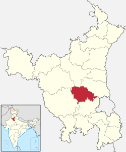 | |
| Cities and towns | ||
| Transport | ||
| Education | ||
| Lok Sabha constituencies | ||