Majura Parkway
| Majura Parkway Australian Capital Territory | |
|---|---|
|
| |
| General information | |
| Type | Parkway |
| Length | 11.5 km (7.1 mi)[1] |
| Built by | Fulton Hogan |
| Maintained by | Territory and Municipal Services |
| History | Construction began in 2013 and was completed in April 2016. |
| Major junctions | |
| South end | |
| North end |
|
| Highway system | |
|
Highways in Australia National Highway • Freeways in Australia Road infrastructure in Canberra | |
| |
The Majura Parkway is an 11.5-kilometre-long (7.1 mi) north–south parkway in the Majura district of the Australian Capital Territory (ACT). It links at its northern end to the Federal Highway and Horse Park Drive at the edge of the Gungahlin district, and at its southern end to the Monaro Highway in Pialligo.
The parkway has been in planning since the 1970s and is considered as being an important access road to and from the Gungahlin district. It largely replaces Majura Road, which lacks the capacity to cope with future increases in traffic. Majura Road was largely retained to provide access to various facilities in the area. The parkway provides a more efficient transport link in the area and conveys a large numbers of freight vehicles. The project was jointly funded by the ACT and Australian Governments, at a total cost of A$288 million. Major construction works commenced in February 2013.
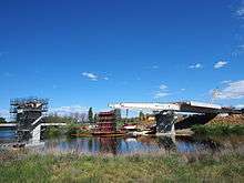
The end of construction for the Majura Parkway project was formally announced on Friday 22 April 2016 coinciding with the naming of the Malcolm Fraser Bridge, the most prominent feature of the project, which runs over the Molonglo River. The bridge's name was unveiled by Tamara 'Tamie' Fraser, wife of the former Prime Minister.[2]
Route description
| Project flyover animations | |
|
| |
|
| |
|
|
| Area map | |
|
|
The Majura Parkway traverses the length of the largely rural Majura Valley within the ACT, providing a parkway standard link between the northern terminus of the Monaro Highway in territory's east and the Federal Highway at the north close to the New South Wales border. The parkway largely replaced Majura Road, which was formerly the main route through the valley and carried approximately 18,000 vehicles each day. Majura Road is single carriageway, and rural in design and quality; the need for the replacement with a more efficient, higher capacity roadway was highlighted in several studies.[3][4] Majura Road remains largely intact to serve local traffic to various facilities located in the Majura Valley, multiple rural properties and Canberra Airport's business precinct.[1] Other benefits of the Majura Parkway include more efficient freight transportation, relieving traffic congestion, supporting future growth of Canberra Airport, and easier movement between Canberra's northern and southern suburbs.[5][6]
The roadway starts as a continuation from the northern end of the Monaro Highway. It then crosses the Molonglo River, and Morshead Drive as part of a singular bridge structure, just to the west of the current Morshead Drive / Pialligo Avenue intersection. The next section of the parkway entirely replaces the northern arm of Morshead Drive with a raised section of roadway, before crossing over Fairbairn Road at the location of the current Morshead Drive / Fairbairn Road intersection.[7][8]
From this point the roadway enters farmland, and grasslands; the parkway itself aligned just to the west of Woolshed Creek. Towards the northern end of the valley, the parkway bisects the Majura Pine Plantation. North of the plantation the parkway gains a service road along its western side, allowing southbound access via an overpass to businesses in that area. This service road continues a short distance to the north until it meets the access road to the Mount Majura air navigation facility, which is located atop the nearby Mount Majura.[7][8]
The remainder of the roadway from the plantation to the north follows the existing Majura Road alignment, with the addition of a second carriageway constructed to the east. It curves towards the west and joins onto the existing interchange with the Federal Highway. The roadway itself then continues on through the interchange into the Gungahlin district as Horse Park Drive.[7][8]
The parkway is dual carriageway for the entirety of its length. Each traffic lane is 3.5-metre (11 ft) wide, with a 2.5-metre (8.2 ft) wide outside shoulder, and a 1-metre (3.3 ft) wide median shoulder. The speed limit is 100 km/h (60 mph). By 2030, the Majura Parkway is expected to carry approximately 40,000 vehicles each day, with 6,000 of those being freight vehicles.[1][9] The stated cost is A$288 million, and is jointly funded by the ACT Government and the Australian Government, both committing $144 million to the project.[10]

History
The planning of Majura Parkway began with the Tomorrow's Canberra (1970) National Capital Development Commission (NCDC) report which identified the Majura Valley corridor as a component of Canberra's peripheral road system. Further NCDC and National Capital Authority (NCA) studies including Metropolitan Canberra (1984) and the Canberra Spatial Plan (2004) identified the need for a primary road link in the area. This was also backed up by the Gungahlin External Travel Study Information Report (1989) identifying four main access roads needed for residents of the Gungahlin district.[3]
From the SMEC Concept Evaluation Report (2006), Roads ACT identified two preferred alignments, which were known as the western and the eastern alignments. The eastern alignment was later scrapped because of environmental, heritage, and social issues along that corridor, leaving the western alignment as the only preferred alignment. The scrapped eastern alignment would have also included a link to a future urban area in the Kowen District. Resumption of land for the parkway mostly involved farmland, although part of the Majura Pine Plantation was acquired for the new road alignment. The Royal Military College, Duntroon has also lost some parts of its playing fields, though the historic Oval No.1 is preserved.[3][7]
Some concerns were raised about the parkway occupying land now used for offroad recreational cycling in the Majura Pine Plantation; however by the later stages of the planning process, two large culverts had been planned in this area which would ease access between both sides of the plantation for recreational cyclists and other users.[11] Concerns were also raised by the Geological Society of Australia in regards to the construction works affecting a fossil site on Woolshed Creek in the vicinity of the Fairbairn Avenue southbound offramp. The Geological Society of Australia later accepted assurances from the ACT Government that the site would be protected.[12][13]
Preparatory roadworks on nearby roads began in 2008, with the main project beginning in September 2012 when Fulton Hogan was awarded the contract to build. Major construction then began in January 2013.[14][15]
The parkway was completed by April 2016.[1] Construction of the parkway created around 350 jobs.[16] At November 2016 the new road was still yet to appear on iPhone maps and some GPS systems.[17]

Intersections and interchanges
The completed Majura Parkway has multiple intersections and interchanges along its length, providing access to facilities in the Majura Valley, and several arterial roads.[18][19][20]
| District[19] | Location[19] | km[1] | mi | Destinations[19][20] | Notes[20] |
|---|---|---|---|---|---|
| Majura, Canberra Central | Pialligo, Campbell, Fyshwick | 0 | 0.0 | Monaro Highway south – Cooma Morshead Drive west – City, Campbell | Half diamond interchange, including bridge over Molonglo River, no northbound onramp, no southbound offramp; Parkway terminus: continues south as Monaro Highway |
| Pialligo, Campbell | Diamond interchange | ||||
| Majura | | Tambreet St east – AFP Training Facility, Innabaanya Girl Guide Camp, Majura Training Area, Mount Majura Winery | Diamond interchange | ||
| | Majura Road east – Majura Defence Range, Mount Majura Winery | Southbound access via LILO T-intersection | |||
| | Mount Majura Road west – Mount Majura air navigation facility, Mount Majura Winery | Northbound access via LILO T-intersection | |||
| | Hector McIntosh Grove northeast – Shooting ranges | Southbound access via LILO T-intersection | |||
| Gungahlin, Majura | | 11.5 | 7.1 | Horse Park Drive west – Gungahlin | Diamond interchange with single cloverleaf offramp, allowing non-stop access to both directions of the Federal Highway. Parkway terminus: continues west as Horse Park Drive |
| |||||

See also
 Australian Roads portal
 Australian Capital Territory portal
References
- 1 2 3 4 5 "Majura Parkway: FAQs". ACT Government. 10 April 2012. Retrieved 28 June 2013.
- ↑ Burgess, Katie (22 April 2016). "New Majura Parkway bridge over Molonglo River to be named after Malcolm Fraser". The Canberra Times. Fairfax Media. Archived from the original on 23 July 2016.
- 1 2 3 "Majura Parkway: Planning History". ACT Government. 10 April 2012. Retrieved 28 June 2013.
- ↑ "Majura Parkway: About the Project". ACT Government. 31 July 2012. Retrieved 28 June 2013.
- ↑ "Project Details: Majura Parkway". Nation Building Program. Australian Government – Department of Infrastructure and Transport. 25 March 2013. Retrieved 28 July 2013.
- ↑ Gallagher, Katy (5 February 2013). "Construction on the Majura Parkway Begins" (Press release). ACT Government. Retrieved 28 July 2013.
- 1 2 3 4 "Chapter 5 (Land Impacts)" (PDF). Majura Parkway Final EIS Report. SMEC. 26 Feb 2010. pp. 5–2. Retrieved 28 June 2013.
- 1 2 3 "Chapter 6 (Ecological Impacts)" (PDF). Majura Parkway Final EIS Report. SMEC. 26 Feb 2010. pp. 6–3. Retrieved 28 June 2013.
- ↑ "Majura Parkway: Design & Construction". ACT Government. 12 April 2012. Retrieved 28 June 2013.
- ↑ "Construction on the Majura Parkway Begins". Minister for Infrastructure and Transport. 5 Feb 2013. Retrieved 29 June 2013.
- ↑ Strachan, Julieanne (10 July 2011). "Race on to save Majura Pines trails". Canberra Times.
- ↑ Hall, Bianca (9 July 2011). "Fears Majura Parkway will run through a significant fossil site". Canberra Times.
- ↑ "Chapter 11 (Consultation Summary Part 1)" (PDF). Majura Parkway Final EIS Report. SMEC. 26 Feb 2010. pp. 11–8. Retrieved 30 June 2013.
- ↑ "Majura Parkway: Associated road works". ACT Government. 10 April 2012. Retrieved 28 June 2013.
- ↑ "Majura Parkway: Early works construction update". ACT Government. 24 December 2012. Retrieved 28 June 2013.
- ↑ "Majura Parkway construction officially begins". ABC News. Australian Broadcasting Corporation (ABC). 5 February 2013. Retrieved 28 July 2013.
- ↑ Brown, Andrew (26 November 2016). "Majura Parkway yet to show up on GPS and iPhone maps, seven months after opening". The Canberra Times. Fairfax Media. Archived from the original on 27 November 2016.
- ↑ "Chapter 3 (The Proposal)" (PDF). Majura Parkway Final EIS Report. SMEC. 26 Feb 2010. pp. 3–4. Retrieved 28 June 2013.
- 1 2 3 4 ACTMAPi (Map). Cartography by Environment and Sustainable Development Directorate. ACT Government. Retrieved 29 June 2013.
- 1 2 3 Google (29 June 2013). "Majura Valley" (Map). Google Maps. Google. Retrieved 29 June 2013.
External links
- Majura Parkway – ACT Government official Majura Parkway website.
- Fulton Hogan – Company contracted to build Majura Parkway.
- SMEC – Company which designed Majura Parkway.
| Controlled-access roads: | ||
|---|---|---|
| Limited-access roads: |
| |
| Major interchanges: | ||
| Proposed or cancelled |
| |
*Partially limited-access ^Partially controlled-access roadway under construction | ||