Queanbeyan
| Queanbeyan New South Wales | |||||||||||||
|---|---|---|---|---|---|---|---|---|---|---|---|---|---|
 Coat of Arms of the City of Queanbeyan | |||||||||||||
|
Queanbeyan Location in New South Wales | |||||||||||||
| Coordinates | 35°21′12″S 149°14′03″E / 35.35333°S 149.23417°ECoordinates: 35°21′12″S 149°14′03″E / 35.35333°S 149.23417°E | ||||||||||||
| Population | 37,991 (2011 census)[1] | ||||||||||||
| • Density | 210/km2 (540/sq mi) | ||||||||||||
| Established | 1838 | ||||||||||||
| Elevation | 576 m (1,890 ft) | ||||||||||||
| Area | 173 km2 (66.8 sq mi) | ||||||||||||
| Time zone | AEST (UTC+10:00) | ||||||||||||
| • Summer (DST) | AEDT (UTC+11:00) | ||||||||||||
| Location | 14.9 km (9 mi) from Canberra | ||||||||||||
| LGA(s) | Queanbeyan-Palerang Regional Council | ||||||||||||
| State electorate(s) | Monaro | ||||||||||||
| Federal Division(s) | Eden-Monaro | ||||||||||||
| |||||||||||||
Queanbeyan /ˈkwiːnbiən/ is a regional centre on the Southern Tablelands in south-eastern New South Wales adjacent to the Australian Capital Territory. The city's mixed economy is based on light construction, manufacturing, service, retail and agriculture. It is the council seat of the Queanbeyan-Palerang Regional Council. At the 2011 census census, Queanbeyan had a population of 37,991.[1]
Following the founding of Canberra, Australia's federal capital, just 15 kilometres (9.3 mi) to the west, Queanbeyan has become an integral part of the capital city's economy. The word Queanbeyan is the anglicised form of Quinbean – an Aboriginal word meaning "clear waters".
History
The town grew from a squattage held by ex-convict and inn keeper, Timothy Beard, on the banks of the Molonglo River in what is now Oaks Estate. The town centre of Queanbeyan is located on the Queanbeyan River, a tributary of the Molonglo River and about one mile east of Oaks Estate.
Queanbeyan was officially proclaimed a township in 1838 when the population was about 50. The local parish was also known by that name and later still the member for the electorate of Queanbeyan held a seat in the legislative assembly of the colony of NSW. On 28 November 1837 the Colonial Secretary announced the appointment of Captain Allured Tasker Faunce as resident police magistrate at Queanbeyan. His homestead, called Dodsworth, was situated on the banks of the Queanbeyan river opposite the town.[2]
Traces of gold were discovered in 1851 and lead and silver mines also flourished briefly. Settlers were harassed by bushrangers, of which James Shaw, William Millet, and John Rueben,[3] John Tennant, Jacky Jacky, Frank Gardiner and Ben Hall were some of the more notorious. In 1836, a Post Office was established.[4]
The Commercial Banking Company of Sydney Limited (CBC, now part of the National Australia Bank) opened in Queanbeyan on 19 September 1859. The Bank of New South Wales began service in Queanbeyan in 1878. The Golden Age (now The Queanbeyan Age) was Queanbeyan's first newspaper and was founded in 1860 by John Gale. In 1880 the residence of John James Wright, the first mayor of Queanbeyan, was constructed along the edge of the Queanbeyan River. In 1982 that building became the Queanbeyan Art Centre.
The Salvation Army claimed an outpost in Queanbeyan in 1884.
Queanbeyan, an increasingly successful primary producing district, was proclaimed a Municipality in February 1885 incorporating an area of 5,700 acres (23 km²). The railway reached Queanbeyan railway station in 1887 and it became the junction for the lines going to Canberra and Bombala. The town is served by the thrice-daily NSW TrainLink Xplorer service between Canberra and Sydney.


William James Farrer, the wheat experimentalist, established Queanbeyan's reputation as an agricultural district with his famous "Federation" rust-free strain, developed on his property "Lambrigg" at Tharwa. Farrer's work was only slowly recognised elsewhere in Australia, but local farmers supported him, particularly in his development of "Blount's Lambrigg", another strain which in 1889 gave hope to farmers after the disastrous season of 1887 when crops had failed after heavy Christmas rains.
At the height of its rural prosperity Queanbeyan boasted sixteen public houses and six flourmills powered by wind, water, horse and steam. The Royal Hotel on Monaro Street opened in 1926. In Canberra alcohol was prohibited from 1911, at the time of the territory's foundation, until 1928, when Federal Parliament had relocated from Melbourne. In that period many of the capital's residents crossed the border to drink at one of Queanbeyan's hotels.
Queanbeyan was granted city status on 7 July 1972. On 21 July 1975 the Queen's Bridge was opened. This bridge took pressure off the existing bridge in linking Monaro Street directly to the east. From 1982 to 1989, the Canberra Raiders rugby league team played their home games in Queanbeyan, at Seiffert Oval.
Since December 2008, the Australian Defence Forces's HQ Joint Operations Command has been based adjacent to the Kowen district of the Australian Capital Territory, just south of the Kings Highway, about 15 km east of Queanbeyan, and 15 km south of Bungendore, New South Wales.
Today
Queanbeyan has two government high schools: Queanbeyan High and Karabar High. Queanbeyan primary schools include Queanbeyan South Public School, Queanbeyan West Public School, Queanbeyan East Public School, Queanbeyan Public School, Jerrabomberra Public School and St Gregory's Primary School.
The Queanbeyan District Hospital is a small but modern facility providing Maternity, Emergency and some Community Health services. Queanbeyan has an ambulance station, indoor and outdoor swimming pool, community centre, performing arts centre, a public library and several parks.
The city's local bus service is Qcity Transit, which also operates routes into Canberra.
Commerce and industry
Queanbeyan has two light manufacturing/industrial precincts centred on Gilmore Road and Yass Road. The Queanbeyan Solar Farm with 720 solar panels has a generating capacity of 50 kW, and is located in the Yass Road area. Queanbeyan has a large and significant retail market in roses, which are sourced from the local district.
Sport and culture
Queanbeyan has a number of sports teams that play in local sports competitions.
| Team | Sport | Tournament |
|---|---|---|
| Queanbeyan Whites | Rugby Union | ACTRU Premier Division |
| Monaro Panthers FC | Association Football | NPL |
| Queanbeyan City FC | Association Football | |
| Queanbeyan Blues | Rugby League | Canberra Rugby League |
| Queanbeyan Kangaroos | Rugby League | Canberra Rugby League |
| Queanbeyan Tigers | Australian Rules Football | AFL Canberra |
| Queanbeyan Cricket Club | Cricket | ACT Cricket Competition |
The Queanbeyan Show, which started over 100 years ago, is held annually at the Queanbeyan Showgrounds in November over two days. There are equestrian events, a sideshow alley, art and craft displays, cooking exhibits, an agricultural pavilion and livestock exhibitions. Also held is a Showgirl, Miss Junior Showgirl and Tiny Tots competition.
In February, the Queanbeyan Showgrounds play host to the annual "Convoy for Kids" to aid cancer research. The event is widely supported by community groups, regional businesses and the emergency services. The event attracts hundreds of commercial vehicles, trucks, prime movers and bushfire brigade vehicles. The highlight of the afternoon is the sounding of horns, which can be heard for miles around. Other regular events throughout the year include the Rodeo in March, Field Days, and a camping and off-road vehicle show.
On 3 December, Queanbeyan hosts an annual Festival of Ability as part of the Don't DIS my ABILITY campaign, celebrating International Day of Persons with Disabilities. The event attracts more than 3,500 people and is a community celebration, acknowledging the strengths, skills and achievements of people with a disability in the Queanbeyan region.
In March 2008, the Queanbeyan Performing Arts Centre - the Q - became the new home for the Queanbeyan Players who have provided over thirty years of live theatre and dramatic entertainment for the Queanbeyan community.[5]
Politics
Federally, Queanbeyan lies within the electorate of Eden-Monaro, currently held by Mike Kelly representing the Australian Labour Party.
At a state level, Queanbeyan is the major population centre in the seat of Monaro, and is currently held by John Barilaro of The Nationals.
Historic places and monuments
- 1838 Anna Maria Faunce memorial: The oldest memorial grave-stone in existence in Queanbeyan was/is that of Anna Maria Faunce (born 30 November 1838), the eight-month-old daughter of Captain Allured Tasker Faunce.[6] The Memorial had not been seen for many years and was rediscovered by the Wheeler family.[7] The broken stone pieces were taken to the Queanbeyan Museum to arrange for repairs, sighted in broken pieces in a box at the Museum in the late 1990s, but the location now, is unknown.[8]
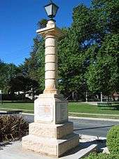
- 1903 QBN Boer War memorial: Made of sandstone, the original memorial, had a gas light on top and was placed at the Monaro and Crawford Streets intersection in Queanbeyan (QBN), it was damaged when hit by a truck in the early 1950s and was repaired and re-erected on the same site. In 1955 the re-erected 1903 Boer War memorial was hit again by the same truck and same driver, Henry Ford, but this time it could not be repaired. As Veterans from the Boer War were still alive and wanted the 1903 Boer War memorial repaired/replaced, a public subscription was raised and a concrete replica memorial was cast and erected in 1964 in the centre-medium strip in Lowe Street,opposite the back of the QBN Courthouse. Although the memorial is a replica and although all the Boer War Veterans have since died, the remembrance, sentiment and respect for those who fought in the Boer War remains; QBN City Council undertakes regular conservation work, and the QBN RSL places a wreath on the Boer War Memorial each ANZAC DAY.[9][10]
- 1923 Soldiers Memorial: Originally named the Soldiers Memorial, unveiled on 25 April 1923 Anzac Day but over time this memorial has had many local names such as the World War 1 memorial, World War 1 and 2 memorial and the World Wars memorial etc. but for many years has also been referred to as the Memorial for all Wars and all who served, be they men or women, who gave service in any capacity. General manager (now retired) Hugh Percy was the man who kicked the local Queanbeyan ANZAC Day ceremony off and got it growing and now every year the local Queanbeyan ANZAC Day ceremony grows bigger and better.[11][12]
- 1936–1938 William Farrer memorial: Located on the central medium strip in Farrer Place, this sandstone and bronze memorial was unveiled in two ceremonies, 1936 and 1938. In 1936 the central sandstone column with the larger than life William Farrer bronze portrait bust at the top, with Raynor Hoff, the artist's signature on the bust and the large central plaque with "Farrer's quote" underneath the bust, were unveiled in 1936; The four smaller wheat-industry bronze-relief plaques (two on either side of the central sandstone column) were probably completed by other artists in Hoff's studio and were unveiled in 1938, during Queanbeyan's 1938 centenary celebrations.[13]
 1923 SOLDIERS memorial unveiled Anzac Day 25 April 1923
.jpg) 1936-1938 William Farrer memorial [13]
1936-1938 William Farrer memorial [13] Memorial Gates - Queanbeyan Showgrounds
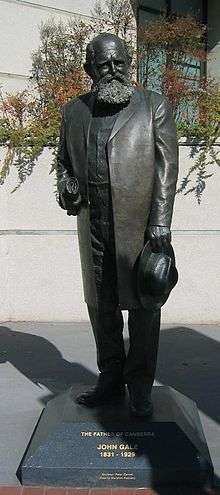 John Gale (journalist) "The Father of Canberra"
 Historical Queanbeyan suspension foot bridge
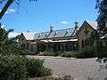 Queanbeyan Railway Station
Notable residents
- Suzanne Balogh - Sport Shooter & Olympic Gold Medal winner.[14]
- David Campese - Rugby Union player (retired), Wallaby winger & 1991 Rugby World Cup winner.
- Terry Campese - Rugby League player, Kangaroos, NSW, Canberra Raiders captain. Nephew of David Campese.
- Anthony Fainga'a - Rugby Union player, Queensland Reds and Wallaby centre.
- Saia Fainga'a - Rugby Union player, Queensland Reds and Wallaby hooker. [15]
- David Furner - Rugby League player (retired), Kangaroos, NSW, Canberra Raiders player and coach.
- Matt Giteau - Rugby Union player for Australian Wallabies, RC Toulonnais and formerly Brumbies and Western Force. Once Australia's highest ever paid domestic player of any code.
- Brad Haddin - Cricketer for NSW and Australia.
- Matt Henjak - Rugby Union player, former Wallaby and Wester Force halfback.
- Joe Janiak - Horse trainer and owner of gelding racehorse Takeover Target,a Group One winner in each Australian State [16]
- Harry Holland - Politician and leader of the New Zealand Labour Party[17]
- Brent Kite - Rugby League player for NSW and Australia.
- Hau Latukefu - ARIA award-winning MC & triple j radio & TV presenter.
- Glenn Lazarus - Senator for Palmer United Party, former Kangaroos, NSW, Canberra Raiders, Brisbane Broncos and Melbourne Storm rugby league player.
- George Lazenby - Actor and only Australian to play James Bond, in On Her Majesty's Secret Service.[18]
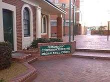
- Megan Marcks (née Still) - Olympic women's (pairs) rowing gold medalist.
- Heather McKay AM, MBE - Australian squash champion.
- Lawrence Mooney - Australian Comedian [19]
- Tommy Murphy - award-winning playwright.
- Omar Musa - Australian poet, hip-hop artist and author.
- Fergus Pragnell - Australian rower and current member of the Australian rowing team.
- Mike Smith - Stage and screen actor.[20]
- Ben Snow - Academy Award nominee for visual effects.[21]
- Ricky Stuart - Rugby League player,former Kangaroos, NSW & Canberra Raiders player, Kangaroos and NSW Coach.
- Mark Webber - FIA World Endurance Championship for Porsche in motorsport and former Formula 1 driver for Red Bull Racing. Winner 2010 Spanish, Monaco, British and Hungarian Grands Prix.[22][23][24] Winner 2011 Brazilian Grand Prix Winner 2012 Monaco and British Grand Prix.
Suburbs
- Carwoola
- Crestwood
- Environa
- Googong
- Greenleigh
- Jerrabomberra
- Karabar
- Queanbeyan East
- Queanbeyan West
- Queanbeyan
- The Ridgeway
- Royalla
- Tralee
- (Oaks Estate is sometimes mistakenly assumed to be part of Queanbeyan but is in fact located in the Australian Capital Territory.)
 Queanbeyan City - Many innercity homes were built during the "Federation era", circa 1927
 Queanbeyan City - Bike paths connect the Queanbeyan CBD to the Canberra bike path network
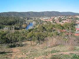 Karabar, New South Wales - The Queanbeyan River and Karabar - a southern Queanbeyan suburb
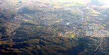
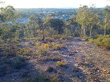 Queanbeyan East, New South Wales - East Queanbeyan as viewed from just outside the city's edge
Climate
| Climate data for Queanbeyan, New South Wales | |||||||||||||
|---|---|---|---|---|---|---|---|---|---|---|---|---|---|
| Month | Jan | Feb | Mar | Apr | May | Jun | Jul | Aug | Sep | Oct | Nov | Dec | Year |
| Average high °C (°F) | 29.0 (84.2) |
28.5 (83.3) |
25.6 (78.1) |
20.6 (69.1) |
15.9 (60.6) |
12.5 (54.5) |
11.8 (53.2) |
13.7 (56.7) |
17.3 (63.1) |
20.7 (69.3) |
24.4 (75.9) |
27.6 (81.7) |
20.6 (69.1) |
| Average low °C (°F) | 12.7 (54.9) |
12.9 (55.2) |
10.7 (51.3) |
6.6 (43.9) |
3.3 (37.9) |
0.9 (33.6) |
−0.2 (31.6) |
0.9 (33.6) |
3.3 (37.9) |
6.0 (42.8) |
8.9 (48) |
11.4 (52.5) |
6.4 (43.5) |
| Average precipitation mm (inches) | 55.4 (2.181) |
50.9 (2.004) |
50.5 (1.988) |
44.0 (1.732) |
43.9 (1.728) |
44.0 (1.732) |
39.5 (1.555) |
44.0 (1.732) |
47.8 (1.882) |
59.6 (2.346) |
59.2 (2.331) |
55.6 (2.189) |
598.4 (23.559) |
| Source: Bureau of Meteorology [25] | |||||||||||||

References
- 1 2 Australian Bureau of Statistics (31 October 2012). "Canberra-Queanbeyan (C) (Statistical Local Area)". 2011 Census QuickStats. Retrieved 18 December 2013.
- ↑ Errol Lea-Scarlet. Queanbeyan. District and People. Queanbeyan Municipal Council 1968 p27.
- ↑ The Sydney Gazette and New South Wales Advertiser Saturday 13 August 1842
- ↑ The Sydney Gazette and New South Wales Advertiser Tuesday 22 March 1836
- ↑ See Governor-General of the Commonwealth of Australia - Speech - Opening of the Queanbeyan Performing Arts Centre Archived 20 July 2008 at the Wayback Machine.
- ↑ Rex Cross. Bygone Queanbeyan. Queanbeyan Publishing Company, 1985 ISBN 0-9591096-0-9
- ↑ Enid Wheeler. The Lost Headstone. Canberra Times. 10 December 1992.
- ↑ Queanbeyan Museum.
- ↑ QBN Age, 1950s–1960s
- ↑ P.B. Sheedy & E.A. Percy. Moneroo to Monaro. Publisher QBN City Council, QBN. ISBN 0 9599895 6 0
- ↑ Queanbeyan Age
- ↑ P.B. Sheedy & E.A. Percy. Moneroo to Monaro, Publisher Queanbeyan City Council, Queanbeyan. ISBN 0 9599895 6 0
- 1 2 Queanbeyan Age, 1936 and 1938.
- ↑ "Olympic profile: Suzy Balogh". Canberra Times. 28 July 2012. Retrieved 3 February 2015.
- ↑ The Canberra Times Online Family ties bind Faingaa twins 6 April 2008 Archived 20 September 2008 at the Wayback Machine.
- ↑ ABC News Takeover Target completes Aussie sweep 2 May 2009
- ↑ O'Farrell, Patrick. "Holland, Henry Edmund - Biography". Dictionary of New Zealand Biography. Ministry for Culture and Heritage. Retrieved 9 January 2016.
- ↑ Gordon, Chris. "Lazenby's Goulburn bond" Goulburn Post, 3 November 2010
- ↑ Doherty, Megan. "Lawrence Mooney brings his existential crisis to Canberra" Canberra Times, 22 November 2016
- ↑ Butler, David (12 November 2012). "A Winning Formula". Retrieved 3 February 2015.
- ↑ ABC News Aussie chases visual effects Oscar 23 January 2009
- ↑ The Sunday Times Online Mark Webber: not your average F1 driver 31 May 2009
- ↑ Official Results 2009 F1 German Grand Prix 12 July 2009
- ↑ BBC Formula One - 2009 Grand Prix results15 February 2009
- ↑ "Climate Statistics for Quenbeyen, New South Wales". Retrieved 20 January 2012.
External links
| Wikiquote has quotations related to: Queanbeyan |
| Wikimedia Commons has media related to Queanbeyan, New South Wales. |