Mandeville, Quebec
| Mandeville | |
|---|---|
| Municipality | |
|
Little Mandeville River | |
| Motto: Tous ensemble en avant | |
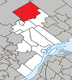 Location within D'Autray RCM. | |
 Mandeville Location in central Quebec. | |
| Coordinates: 46°22′N 73°21′W / 46.367°N 73.350°WCoordinates: 46°22′N 73°21′W / 46.367°N 73.350°W[1] | |
| Country |
|
| Province |
|
| Region | Lanaudière |
| RCM | D'Autray |
| Settled | 1824 |
| Constituted | April 20, 1904 |
| Government[2] | |
| • Mayor | Francine Bergeron |
| • Federal riding | Berthier—Maskinongé |
| • Prov. riding | Berthier |
| Area[2][3] | |
| • Total | 339.30 km2 (131.00 sq mi) |
| • Land | 322.22 km2 (124.41 sq mi) |
| Population (2011)[3] | |
| • Total | 2,043 |
| • Density | 6.3/km2 (16/sq mi) |
| • Pop 2006-2011 |
|
| • Dwellings | 1,770 |
| Time zone | EST (UTC−5) |
| • Summer (DST) | EDT (UTC−4) |
| Postal code(s) | J0K 1L0 |
| Area code(s) | 450 and 579 |
| Highways | No major routes |
| Website |
www |
Mandeville is a municipality in the D'Autray Regional County Municipality in the Lanaudière region of Quebec, Canada.
Topography
Prior to June 2, 2001, it was officially known as Saint-Charles-de-Mandeville.
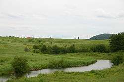
The town itself is located along the Mastigouche River, just north of Lake Maskinongé. The municipal territory is dotted with lakes, many of which are lined with cottages. The northern portion is undeveloped and part of the Mastigouche Wildlife Reserve. Mandeville is considered a paradise for hunting and trapping (bear, moose, wolf, lynx) and fishing (musky, trout, bass).[1]
Mandeville is home to the Pléïades Observatory, managed by Centre d'Observation et de Recherche Astronomique Mandeville (C.O.R.A.M. Inc.).
History
In the early 19th century, the territory was part of the Hope Fief. This fief, with an area of 20,000 arpents (68.4 km²) was granted to Angélique Blondeau by Seignoral Lord Charles-Louis Tarieu de Lanaudière, but was mostly neglected by the seignoral lords. In 1824, one of the first settlers, Maximillien or Maxime Mandeville, arrived at the shores of the lake that today bears his name. And in 1837, further colonization occurred when a large group of settlers came from Maskinongé, Berthierville, and Sorel.[1][4]
In 1894, the Mission of Saint-Charles-de-Mandeville was formed and became a parish in 1903. The name is most likely a reference to Charles Turgeon, pastor of the nearby parish of Saint-Didace, who worked extensively in Mandeville. In 1904, the Municipality of Saint-Charles-de-Mandeville was established and in 1905, its post office opened.[1]
Since the toponym "Saint-Charles" had not been in common use for a long time, the municipality officially abbreviated its name to Mandeville in 2001.[1] Soon after, the municipal boundary between Mandeville and Saint-Damien was reorganized, and Mandeville gained about 146 square kilometres (56 sq mi).
Demographics
- Population in 2011: 2043 (2006 to 2011 population change: -8.0 %)
- Population in 2006: 2221
- Population in 2001: 1878 (or 1962 when adjusted for 2006 boundaries)
- Population in 1996: 1824
- Population in 1991: 1725
- Population in 1986: 1538
- Population in 1981: 1392
- Population in 1976: 1240
- Population in 1971: 1240
- Population in 1961: 1236
- Population in 1950: 1378
- Population in 1940: 1250
- Population in 1930: 951
- Population in 1910: 1072
- Population in 1900: 551
Private dwellings occupied by usual residents: 1005 (total dwellings: 1770)
Mother tongue:[6]
- English as first language: 1.1%
- French as first language: 97.7%
- English and French as first language: 0.7%
- Other as first language: 0.5%
Mayors
The mayors of Mandeville were:[7]
- Séraphin Baril 1905-1906
- Joseph Dulac 1907-1908
- Joseph Prescott 1908-1913, 1916-1924, 1926-1932
- Amédée Sylvestre 1914-1915
- Joseph Charpentier 1925-1926
- Henri Pontbriand 1933-1934
- Albert Charbonneau 1935-1947
- Alcide Desjardins 1948-1960, 1963-1970
- Alfred Prescott 1961-1962
- Roger Dupuis 1971
- Donat Savoie 1972-1978, 1981-1983
- Réal Bilodeau 1979-1980
- Jacques Prescott 1983-1995
- Roland Rocheleau 1995-1999
- François Benjamin 1999-2007
- Francine Bergeron 2007-
See also
References
- 1 2 3 4 5 "Mandeville (Municipalité)" (in French). Commission de toponymie du Québec. Retrieved 2009-11-23.
- 1 2 Geographic code 52095 in the official Répertoire des municipalités (French)
- 1 2 Statistics Canada 2011 Census - Mandeville census profile
- 1 2 "Historique" (in French). Municipalité de Mandeville. Retrieved 2009-11-23.
- ↑ Statistics Canada: 1996, 2001, 2006, 2011 census
- ↑ Statistics Canada 2006 Census - Mandeville community profile
- ↑ "Nos maires" (in French). Municipalité de Mandeville. Retrieved 2009-11-23.
External links
 |
Saint-Zénon | Baie-de-la-Bouteille | | |
| Saint-Damien | |
Saint-Alexis-des-Monts | ||
| ||||
| | ||||
| Saint-Gabriel | Saint-Gabriel-de-Brandon | Saint-Didace |
| Cities & Towns | |
|---|---|
| Municipalities | |
| Parishes | |
| |