Mangareva
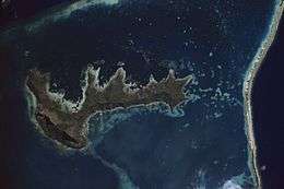 NASA picture of Mangareva Island | |
 Mangareva | |
| Geography | |
|---|---|
| Location | Pacific Ocean |
| Coordinates | 23°06′34″S 134°57′57″W / 23.10944°S 134.96583°WCoordinates: 23°06′34″S 134°57′57″W / 23.10944°S 134.96583°W |
| Archipelago | Tuamotus |
| Area | 15.4 km2 (5.9 sq mi) |
| Length | 8 km (5 mi) |
| Highest elevation | 441 m (1,447 ft) |
| Highest point | Mt. Duff |
| Administration | |
|
France | |
| Overseas collectivity | French Polynesia |
| Administrative subdivision | Tuamotus |
| Commune | Gambier Islands |
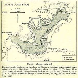
| Largest settlement | Rikitea |
| Demographics | |
| Population | 1239[1] (2012) |
Mangareva is the central and largest island of the Gambier Islands in French Polynesia. It is surrounded by smaller islands: Taravai in the southwest, Aukena and Akamaru in the southeast, and islands in the north. Mangareva has a permanent population of 1,239 (2012) and the largest village on the island, Rikitea, is the chief town of the Gambier Islands.
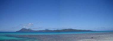
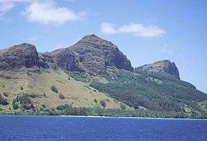
The island is approximately 8 km long and, at 15.4 km², it comprises about 56% of the land area of the whole Gambier group. Mangareva has a high central ridge which runs the length of the island. The highest point in the Gambiers is Mt. Duff, on Mangareva, rising to 441 m along the island's south coast. The island has a large lagoon 24 km in diameter containing reefs whose fish and shellfish helped ancient islanders survive much more successfully than on nearby islands with no reefs.
History
Mangareva was once heavily forested and supported a large population that traded with other islands via canoes. However, excessive logging by the islanders during the 10th to the 15th centuries resulted in deforestation of the island, with disastrous results for its environment and economy (see Gambier Islands for more details).
The first European to arrive to Mangareva was British Captain James Wilson in 1797 on ship Duff. Wilson named the island group in honour of Admiral James Gambier, who had helped him to equip his vessel.
Mangareva along with its dependices in the Gambier Islands were ruled by a line of kings and later regents that ruled until the French formally annexed the islands in 1881. A French protectorate was requested on 16 February 1844 by King Maputeoa but was never ratified by the French government. On 4 February 1870, Prince Regent Arone Teikatoara and the Mangarevan government formally withdrew the protectorate request and asked the French to not intervene in the kingdom's affair. After Father Honoré Laval was removed to Tahiti, the native government changed their stance and an agreement between Prince Regent Arone and the French colonial authority in Tahiti was signed reaffirming the protectorate status on 30 November 1871. The Gambier Islands were finally annexed on 21 February 1881 under Prince Regent Bernardo Putairi and approved by the President of France on 30 January 1882.[2]
Mangareva's history and its ancient links with the Pitcairn and Henderson islands is well-covered in Jared Diamond's book, Collapse: How Societies Choose to Fail or Succeed (2005).[3]
Transportation
Mangareva is reached by boat from the nearby airport.
Mangareva is an important travel link to Pitcairn Island. Practically the only way a traveler can reach Pitcairn Island is to fly to Tahiti, then to Mangareva. From there, a 32-hour boat ride will take one to the island. Some reach Pitcairn by commercial shipping traffic, but that is less and less common as shipping lanes do not typically pass close to Pitcairn.
Culture and fiction
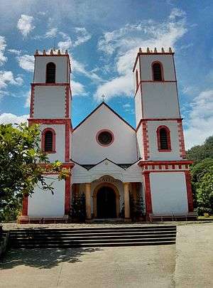
Painter and author Robert Lee Eskridge's book Manga Reva: The Forgotten Islands (Bobbs Merrill; 1931) offers first-hand observations of the environment, peoples, and traditions of Mangareva. It includes original illustrations and photographs by the author. In 1962, adventure-fiction writer Garland Roark acknowledged Eskridge's work in a foreword to his novel The Witch of Manga Reva. Eskridge also wrote and illustrated a children's book about his visit to Mangareva: South Sea Playmates (Bobbs Merrill; 1933).
Binary system
The Mangarevan people had developed a binary number system 300 years ahead of Europeans.[4] The discovery of the binary system being used as far back as 1450 CE is particularly surprising, given its location.
This old way of common numbering has been all but lost. Because the islands were controlled by the French for such a long period, the Arabic number system with which the West is most familiar has taken its place. Researchers Andrea Bender and Sieghard Beller discovered that mathematicians on the island combined the two number systems into a novel binary system. This allowed them to cut down on the number of digits involved in traditional binary systems. For example, 130 is represented in binary as 10000010. In the Mangarevan system, it is represented by VTK. V (varu) stands for 80, T (tataua) is 40, and K (takau) is 10.
Gallery
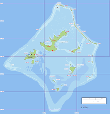 Location within the Gambier Islands
 Aerial view
 Coastal view
See also
| Wikivoyage has a travel guide for Mangareva. |
References
- ↑ "Population". Institut de la statistique de la Polynésie française. Retrieved 5 October 2014.
- ↑ Gonschor, Lorenz Rudolf (August 2008). Law as a Tool of Oppression and Liberation: Institutional Histories and Perspectives on Political Independence in Hawaiʻi, Tahiti Nui/French Polynesia and Rapa Nui. Honolulu: University of Hawaii at Manoa. pp. 56–59. hdl:10125/20375.
- ↑ Jared Diamond, Collapse: How Societies Choose to Fail or Succeed (2005), ch. 3.
- ↑ Bender, A; Beller, S (2013). "Mangarevan invention of binary steps for easier calculation". Proc. Natl. Acad. Sci. USA. 111 (4): 1322–1327. doi:10.1073/pnas.1309160110. Retrieved 2 September 2014.
External links
| Wikimedia Commons has media related to Mangareva. |
Tuamotus Gambiers | Islands/Atolls: | ||
|---|---|---|---|
| Island groups: | |||