Rikitea
| Rikitea | |
|---|---|
| Town | |
 | |
 Rikitea Location in French Polynesia | |
| Coordinates: 23°7′13″S 134°58′9″W / 23.12028°S 134.96917°WCoordinates: 23°7′13″S 134°58′9″W / 23.12028°S 134.96917°W | |
| Country |
|
| Overseas collectivity |
|
| Territory | Gambier Islands |
| Island | Mangareva |
Rikitea is a small town on Mangareva, which is part of the Gambier Islands in French Polynesia. A majority of the islanders live in Rikitea.[1][2] The island was a protectorate of France in 1871 and was annexed in 1881.[3]
History
The town's history dates to the era when the island was first settled with people from the Marquesas Islands in 1100 AD. Captain James Wilson of the London Missionary Society arrived in 1797 on Duff, naming the islands after the English Admiral James Gambier who had facilitated his expedition.[3]
Before the Catholic missionaries' arrival, cannibalism was practiced under the rule of the local kings. French Picpus priests Father François Caret and Father Honoré Laval, of the Congregation for the Sacred Hearts, landed here in 1834. They arrived from Chile.[4] After Caret left for Tahiti, Laval administered the town under his rule, enslaving the native population. It is said that an old man of the island had predicted that "two magicians whose god was all powerful would come". Laval overturned the most feared stone statue of the god Tu on the religious marae of the island. He acted with single-minded purpose and determination to enforce Christian morals and conscripted the island population as slaves in order to build a cathedral and other structures in the town. His ruthless actions resulted in almost total decimation of the local people; a population of 9,000 was reduced to 500. In 1871, Laval was removed from Mangareva on a French warship, convicted of murder in Tahiti, and declared mad.[3] Father Hippolyte Roussel, who had arrived at Rikitea with more than 100 Rapa Nui people on 4 July 1871, assumed charge of Laval's Rikitea mission, and served there till he died in 1898.[5]
Geography

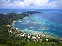
Rikitea is a port town and tourist center situated on Mangareva Lagoon, which contains a number of motu. It is about 1,650 kilometres (1,030 mi) southeast of Tahiti, to the North of the Tropic of Capricorn. The average elevation of the town is 8 metres (26 ft).[6][1][7][2]
The total population of the island was 1100 and most of them lived in Rikitea.[3]
Two mountains, Mt. Duff (482 metres (1,581 ft)) and Mt. Mokoto (129 feet (39 m)), which are approachable by trails, are north of the town.[3][7] The climb to Duff's peak takes about 90 minutes. The stones found on the hill were used by the ethnic Mangarevans to predict weather and to look for boats headed for the island.[1] The mountain is covered with tall aeho grass.[3]
Economy
Black pearls are cultured on numerous platforms on both sides of the Mangareva lagoon.[1] The lagoon is full of corals and black-lipped oysters are harvested by the people.[4] The inhabitants are also involved in agriculture and fishing to the minimum level.[7] The church is involved in technical school (CED, "Center for Educational Development) to train people in skill trades such as carpentry, mechanics, electricity, and mother-of-pearl shell engraving.[8]
Landmarks
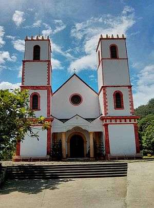
Laval built 116 stone buildings and arches,[3] and roads were laid. Buildings included a fortified palace with follies as well as St. Michael's Cathedral which has also been characterized as a folly. The structures were built with shaped coral stone blocks.[4] Several of the structures dating to Laval's time still remain, such as the watch towers on the coast and a turret, the remains of the palace built for Maputeoa, the last king of the island.[1] King Maputeoa's crypt is located in the St. Pierre's Chapel behind the neo-Gothic St. Michael's Cathedral.[9][10]
The Couvent Rouru (Rouru Convent), near the southern end of the cemetery, is now in ruins, but housed 60 nuns at one time.[1] There is a carving school near the cathedral at Camika CED which features mother of pearl carvings. Here training is provided in the art of shell engraving. Pendants and barrettes created here can be purchased at the centre’s sales outlet. Riktea has a large nuclear fall-out shelter which was built at the time of the French atmospheric testing at Moruroa.[3]
The town also has post office, a few shops, a military establishment, a medical room, and schools.[3] Accommodation of note includes Chez Pierre et Mariette near the wharf, with three rooms, and Pension Bianca et Benoit, in the southern part of the town.[11]
Transportation
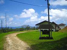
The town is accessed by air and by ship. The airport is located on Mou Toregegie, 9 kilometres (5.6 mi) NorthEast. From the airport, boats provide the only access to Rikitea. Flights operate from Pape'ete and take four and half hours. Travel by ship originates only from Pepe'ete, a journey of 21 days, with stops at four other islands before arriving at the Rikitea.[12] A 28 kilometres (17 mi) road circles the entire island.[3]
References
- 1 2 3 4 5 6 Brash & Carillet 2009, p. 240.
- 1 2 "Population of Rikitea, French Polynesia". population.mongabay.com. Retrieved 15 June 2015.
- 1 2 3 4 5 6 7 8 9 10 Stanley 1999, p. 266.
- 1 2 3 Cruising World. October 2006. pp. 53–. ISSN 0098-3519.
- ↑ Fischer 1997, p. 35.
- ↑ Kelly 2008, p. 202.
- 1 2 3 "Gambier Islands:Archipelago, French Polynesia". Encyclopedia Britannica. Retrieved 15 June 2015.
- ↑ Carlson, Dany T. "Mangareva:Mangareva Today (1999)". pvs.kcc.hawaii.edu. Retrieved 15 June 2015.
- ↑ Stanley 1999, p. 265.
- ↑ "Mausolée du Roi Maputeoa". Tahiti Heritage. Retrieved 20 June 2015.
- ↑ Stanley 2004, p. 268.
- ↑ Kelly 2008, p. 201.
Bibliography
- Brash, Celeste; Carillet, Jean-Bernard (2009). Tahiti and French Polynesia. Lonely Planet. ISBN 978-1-74104-316-7.
- Fischer, Steven R. (1997). Rongorongo: The Easter Island Script : History, Traditions, Texts. Clarendon Press. ISBN 978-0-19-823710-5.
- Kelly, Alexis C. (21 October 2008). Fodor's Tahiti & French Polynesia. Fodor's Travel Publications. ISBN 978-1-4000-0683-0.
- Stanley, David (1999). South Pacific Handbook. David Stanley. ISBN 978-1-56691-172-6.
- Stanley, David (2004). Moon Handbooks South Pacific. David Stanley. ISBN 978-1-56691-411-6.
External links
 Media related to Rikitea at Wikimedia Commons