Manja, Madagascar
| Manja | |
|---|---|
 Manja Location in Madagascar | |
| Coordinates: 21°26′S 44°20′E / 21.433°S 44.333°E | |
| Country |
|
| Region | Menabe |
| District | Manja |
| Elevation[1] | 253 m (830 ft) |
| Population (2001)[2] | |
| • Total | 9,000 |
| Time zone | EAT (UTC3) |
Manja is a town and commune (Malagasy: kaominina) in Madagascar. It belongs to the district of Manja, which is a part of Menabe Region. The population of the commune was estimated to be approximately 9,000 in 2001 commune census.[2]
Manja is served by a local Manja Airport. In addition to primary schooling the town offers secondary education at both junior and senior levels. The town provides access to hospital services to its citizens. It is also a site of industrial-scale mining.[2]
The majority 80% of the population of the commune are farmers, while an additional 17% receives their livelihood from raising livestock. The most important crop is rice, while other important products are beans, cassava and onions. Industry and services provide employment for 0.5% and 2.5% of the population, respectively.[2]
References and notes
- ↑ Estimated based on DEM data from Shuttle Radar Topography Mission
- 1 2 3 4 "ILO census data". Cornell University. 2002. Retrieved 2008-03-11.
| Belo sur Tsiribihina | 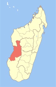 | |
|---|---|---|
| Mahabo | ||
| Manja | ||
| Miandrivazo | ||
| Morondava | ||
Coordinates: 21°26′S 44°20′E / 21.433°S 44.333°E