Liberty of the Savoy
| The Savoy Liberty of the Duchy of Lancaster | |
|---|---|
 | |
| History | |
| • Created | 1246 |
| Status | Manor, Liberty |
| Government |
Court Leet of the Savoy |
| • HQ | Somerset House |
| Subdivisions | |
| • Type | Wards (4) |
| • Units | Church, Middle, Royal, Savoy |
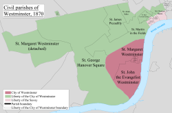
The Savoy was a manor and liberty located between the Liberty of Westminster and the City of London in the county of Middlesex. The Savoy formed part of the Duchy of Lancaster, and was also known as the Liberty of the Duchy of Lancaster. The duchy continues to have land holdings within the area. The manor and liberty included parts of the parishes of St Clement Danes, St Mary le Strand and the whole of the precinct of the Savoy.
History
Toponymy
Savoy is derived from Peter II, Count of Savoy who was granted land by Henry III in 1246.[1]
Palace and hospital
In 1245 a palace was built by Simon de Montfort, 6th Earl of Leicester. Following his death, the palace was granted by Henry III to Peter of Savoy, uncle of his queen, Eleanor of Provence, and was renamed Savoy Palace.[2] Peter in turn gave the palace to the Congregation of Canons of the Great Saint Bernard, and it became the "Great Hospital of St Bernard de Monte Jovis in Savoy".[2] The hospital was purchased by Queen Eleanor who gave the site to her second son, Edmund, Earl of Lancaster. When Edward I became king, he confirmed the ownership of the Savoy area to Edmund with letters patent.[2]
Duchy liberty
In 1351 Henry of Grosmont, a great-grandson of Henry III, was created the 1st Duke of Lancaster for services in the Hundred Years War. The seat of Lancaster in Lancashire was raised to a county palatine.[notes 1] This meant the area was ruled by hereditary noblemen possessing special authority and autonomy from the rest of the Kingdom of England. Although the noblemen swore allegiance to the king, they had the power to rule the county and its contiguous land largely independently of the king. All other properties attached to the Duchy of Lancaster, including the Savoy became subject to the laws of the duke. As a consequence, someone being pursued for a debt in London could reside in the Savoy without fear of arrest by people acting under the authority of The Crown. Royal writs were not enforceable within the County of Lancashire until the 19th century. Lancaster had its own Court of Chancery until the 1970s. These circumstances have been used in historical fiction, such as the Aubrey-Maturin novels by Patrick O'Brian.
Governance
The area was a parcel of the Duchy of Lancaster. It was divided into four wards, Church, Middle, Royal and Savoy. It was governed by a court leet.[3]
The liberty of the Savoy was part of the county of Middlesex, and those connected with it who were eligible to vote at parliamentary elections were electors for Westminster.[4]
The Liberty of the Savoy was a franchise coroner's district until 1930, when it became part of the Central district of the County of London.[5][6]
The practice of beating the bounds was abandoned by the Duchy of Lancaster in 1969 and revived in 2010.[7]
Geography
The Savoy had the River Thames as its southern boundary and was located primarily to the south of the Strand. It was made up of the following parishes and extra-parochial places (from west to east):
- Part of the parish of St Clement Danes (south of the Strand, now location of Savoy Hotel)
- All of the Precinct of the Savoy
- Part of the parish of St Clement Danes (north of the Strand, around Burleigh House/Lyceum Theatre)
- Part of the parish of St Mary le Strand (now mostly taken up by Somerset House)
- Part of the parish of St Clement Danes (south of the Strand)
The boundaries of the manor and liberty are indicated with a series of markers.
Notes
- ↑ Palatine is an adjective used in conjunction with the noun county; Palatinate is a noun used alone: Collins Dictionary, op.cit.
References
- ↑ Mills, D. (2000). Oxford Dictionary of London Place Names. Oxford.
- 1 2 3 Walter Thornbury (1878). "The Savoy". Old and New London: Volume 3. British History Online. Retrieved 26 February 2010.
- ↑ Joseph Ritson (1789). A digest of the proceedings of the Court Leet and of the manor and liberty of the Savoy.
- ↑ "Westminster".
- ↑ http://www.london-gazette.co.uk/issues/33660/pages/7174/page.pdf
- ↑ http://www.aim25.ac.uk/cgi-bin/vcdf/detail?coll_id=14584&inst_id=118&nv1=browse&nv2=sub
- ↑ http://www.churchtimes.co.uk/articles/2010/4-june/gazette/london-stately-beating
External links
- Map of the Savoy Liberty, 1830
- 'The Savoy', Old and New London: Volume 3 (1878)
- "The Savoy". Retrieved 5 May 2006.
- "The Patrick O'Brian Newsletter: Volume 2, Issue 2 October 1993". Retrieved 8 May 2006.
- "The early History of Piccadilly". Retrieved 5 May 2006.
History of the formation of the City of Westminster | ||
|---|---|---|
| Metropolitan boroughs |  | |
| District boards | ||
| Parishes | ||
| Liberties | ||
Coordinates: 51°30′35″N 0°07′12″W / 51.5097°N 0.1200°W