Martin Mill railway station
| Martin Mill | |
|---|---|
|
Martin Mill station | |
| Location | |
| Place | Martin Mill |
| Local authority | Dover |
| Grid reference | TR341466 |
| Operations | |
| Station code | MTM |
| Managed by | Southeastern |
| Number of platforms | 2 |
| DfT category | E |
|
Live arrivals/departures, station information and onward connections from National Rail Enquiries | |
| Annual rail passenger usage* | |
| 2004/05 | 32,990 |
| 2005/06 |
|
| 2006/07 |
|
| 2007/08 |
|
| 2008/09 |
|
| 2009/10 |
|
| 2010/11 |
|
| 2011/12 |
|
| 2012/13 |
|
| 2013/14 |
|
| 2014/15 |
|
| History | |
| Key dates | Opened 17 June 1881 |
| National Rail – UK railway stations | |
| * Annual estimated passenger usage based on sales of tickets in stated financial year(s) which end or originate at Martin Mill from Office of Rail and Road statistics. Methodology may vary year on year. | |
|
| |
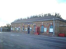
Martin Mill railway station serves the small village of Martin Mill in East Kent. The station and all trains serving it are operated by Southeastern. The booking office is open only on weekday mornings however a Permit To Travel ticket machine on the Dover-bound platform caters for out-of-hours ticketing.
Service
As of January 2015 the typical off-peak service from the station is one train per hour to St Pancras International via Dover Priory and Ashford International and one train per hour also to St Pancras but via the coastal loop route of Ramsgate, Herne Bay and Gravesend.
| Preceding station | |
Following station | ||
|---|---|---|---|---|
| Dover Priory | Southeastern Kent Coast Line |
Walmer | ||
History
Martin Mill also served as an important station during both the First and Second World Wars. During the construction of Dover Harbour in 1897 a single track branch was constructed to bring in materials from Martin Mill. The track ran over the surface of the high chalk plateau parallel with the Dover-Deal main line, before climbing up to the summit just at the entrance to Guston tunnel. From there, it ascended to the cliff top, 350 ft above sea level. It then descended in a zig-zag formation on a vertiginous shelf which was cut into the cliff, leading down to the eastern part of the harbour. The route was reopened during both wars, and operated mainly by Royal Engineers to deploy mounted artillery on the cliff edge.[1] During the Second World War, the branch served the many gun batteries along the white cliffs between Dover and St Margarets. Along this track ran two track-mounted 14 inch guns/cannons nicknamed Winnie (after Winston Churchill) and Pooh (after the fictional bear). During the war they fired into France at German targets, but accuracy was a problem and more damage was done to local property than their actual targets.[2]
This line also ran down to Dover Harbour along a cliff road.
References
- ↑ White, H.P. (1987). Forgotten Railways: South-East England (Forgotten Railways Series). Newton Abbott, Devon: David & Charles. pp. 137–138, 158–159. ISBN 0-946537-37-2.
- ↑ The Coastguard
External links
- Train times and station information for Martin Mill railway station from National Rail
Coordinates: 51°10′16″N 1°20′53″E / 51.171°N 1.348°E