Folkestone Central railway station
| Folkestone Central | |
|---|---|
 | |
| Location | |
| Place | Folkestone |
| Local authority | District of Shepway |
| Grid reference | TR220362 |
| Operations | |
| Station code | FKC |
| Managed by | Southeastern |
| Number of platforms | 2 |
| DfT category | C1 |
|
Live arrivals/departures, station information and onward connections from National Rail Enquiries | |
| Annual rail passenger usage* | |
| 2004/05 | 0.877 million |
| 2005/06 |
|
| 2006/07 |
|
| 2007/08 |
|
| 2008/09 |
|
| 2009/10 |
|
| 2010/11 |
|
| 2011/12 |
|
| 2012/13 |
|
| 2013/14 |
|
| 2014/15 |
|
| History | |
| 1 September 1884 | Opened as "Cheriton Arch" |
| September 1886 | Renamed (Radnor Park) |
| 1 June 1895 | Renamed (Folkestone Central) |
| National Rail – UK railway stations | |
| * Annual estimated passenger usage based on sales of tickets in stated financial year(s) which end or originate at Folkestone Central from Office of Rail and Road statistics. Methodology may vary year on year. | |
|
| |
Folkestone Central railway station is one of two railway stations in Folkestone, Kent, England. It is the more central of the two main stations in the town. The station, and all trains serving it, is operated by Southeastern.
History
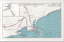
The South Eastern Main Line reached Folkestone in 1843, with a station being opened at Folkestone Junction (Folkestone East) on 18 December 1843. Folkestone West was then opened in 1864, with a station named Cheriton Arch being provided between the two on 1 September 1884. The name Radnor Park was adopted in 1886, and for a few years with just two platform faces, the station was rebuilt in 1890 to add a bay.[1] The station was renamed Folkestone Central in 1895.
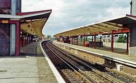
The station was rebuilt at the time of the route's electrification in 1961[2] with two island platforms, linked by a subway and with ramps leading up from the ticket office and concourse, which is itself above street level (an approach road and accompanying pedestrian ramp leads up from Cheriton Road). In 1999 one island platform was abandoned, along with the subway; the platform has not been demolished, although all buildings have been removed.[1]
Services to and from Dover Priory were suspended on 24 December 2015 due to major damage to the track and sea wall near Dover harbour caused by strong winds & tidal surges.[3] A replacement bus service was operation between the two stations, along with a modified timetable whilst repair work was carried out. This was expected to continue throughout 2016, whilst a new £44.5 million viaduct was constructed to replace the old rail embankment & sea wall.[4] The line reopened on 5 September 2016, as the work progressed faster than originally anticipated.[5]
Services
The off-peak service as of September 2016 is:
- 1tph (trains per hour) to London St Pancras
- 1tph to London Charing Cross, which run via Sevenoaks
- 2tph to Dover Priory of which one continues to St Pancras via Ramsgate and Chatham
| Preceding station | |
Following station
- | ||
|---|---|---|---|---|
| Folkestone West | Southeastern South Eastern Main Line |
Dover Priory | ||
| Folkestone West | Southeastern High Speed 1 London-Dover |
Dover Priory | ||
| Disused railways | ||||
| Folkestone West Line and station open |
British Rail Southern Region South Eastern Main Line |
Folkestone East Line open, station closed | ||
| Folkestone Warren Halt Line open, station closed | ||||
| Folkestone West Line and station open |
SECR Folkestone Harbour Branch |
Folkestone Harbour Line and station closed | ||
References
- 1 2 "Folkestone Central". Retrieved 2008-10-09.
- ↑ Body, Geoffrey. PSL Field Guide – Railways of the Southern Region (1984), pages 96–97. Patrick Stephens Ltd, Cambridge. ISBN 0-85059-664-5
- ↑ "Railway between Dover Priory and Folkestone Central closed after damage to sea wall"Network Rail Media Centre 27 December 2015; Retrieved 5 February 2016
- ↑ "Dover to Folkestone railway expected to reopen in December"Network Rail press release; Retrieved 8 April 2016
- ↑ "Dover to Folkestone railway to reopen on Monday, 5 September, three months ahead of schedule."Network Rail press release 22 August 2016; Retrieved 25 August 2016
External links
Coordinates: 51°04′58″N 1°10′11″E / 51.0827°N 1.1697°E
- Train times and station information for Folkestone Central railway station from National Rail