Maryland Route 222
| ||||
|---|---|---|---|---|
|
Maryland Route 222 highlighted in red | ||||
| Route information | ||||
| Maintained by MDSHA | ||||
| Length: | 11.36 mi[1] (18.28 km) | |||
| Existed: | 1972 – present | |||
| Tourist routes: |
| |||
| Major junctions | ||||
| South end: |
| |||
| North end: |
| |||
| Location | ||||
| Counties: | Cecil | |||
| Highway system | ||||
| ||||

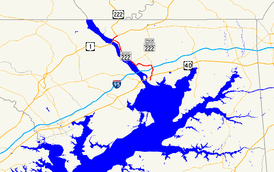
Maryland Route 222 (MD 222) is a state highway in the U.S. state of Maryland. The highway runs 11.36 miles (18.28 km) from MD 7 in Perryville north to U.S. Route 1 (US 1) near Conowingo. MD 222 connects Perryville, Port Deposit, and Conowingo along its route paralleling the Susquehanna River in western Cecil County. Due to limitations in the highway in Port Deposit, including a steep hill and a low railroad bridge, the state highway has a truck bypass that uses MD 275, MD 276, and US 1 through Woodlawn and Rising Sun to connect Interstate 95 (I-95) with US 222 in Conowingo.
MD 222 was originally constructed as MD 268, a number presently assigned to North Street in Elkton. The state highway was paved from Perryville to Port Deposit in the late 1910s and early 1920s. MD 268 was extended north to Conowingo in the early 1930s. In 1938, MD 268 was superseded when US 222 was extended south from US 1 in Conowingo to US 40 in Perryville. US 222 was widened from Perryville to Port Deposit in the early 1940s and reconstructed around 1960. The highway was relocated for the construction of I-95 interchange in the early 1960s and reconstructed south to Perryville in the late 1960s. MD 222 was established in 1972 on the portion of US 222 between MD 7 and US 40. The designation was extended from Perryville to Conowingo in 1995 when US 222 was rolled back to its former and present terminus at US 1 in Conowingo.
Route description
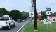
MD 222 begins at an intersection with MD 7 (Broad Street) in the town of Perryville. The highway heads north as two-lane Aiken Avenue, which reaches its northern end at US 40 (Pulaski Highway) immediately to the east of the toll plaza for the Thomas J. Hatem Memorial Bridge. MD 222 continues northeast as Perryville Road, which crosses over CSX's Philadelphia Subdivision. The highway curves north and leaves the town of Perryville and passing Perryville High School. MD 222 intersects the southern end of MD 824 (Reservoir Road) and the entrance to the Perryville Outlet Center before meeting I-95 (John F. Kennedy Memorial Highway) at a four-ramp partial cloverleaf interchange. At the north end of the interchange, the highway briefly re-enters the town of Perryville, intersects the ramps to and from southbound I-95 and the entrance to Hollywood Casino Perryville, and reaches a four-way intersection with the northern end of MD 824 (Blythedale Road) and MD 275 (Perrylawn Drive). MD 222 Truck follows MD 275 north toward Rising Sun, and MD 222 turns west onto Bainbridge Road toward Port Deposit.[1][2]
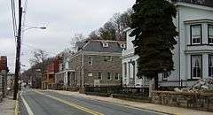
MD 222 heads westfarmland, crossing Happy Valley Branch before passing the entrance to the former United States Naval Training Center, Bainbridge, which contains the Edward W. Haviland House and the original campus of the Tome School. The highway descends from a high bluff to the Susquehanna River, during which southbound MD 222 has a climbing lane. Upon entering the town limits of Port Deposit, MD 222's name changes to Main Street and the highway makes a sharp turn to the north to parallel the river and Norfolk Southern Railway's Port Road Branch. The state highway intersects MD 276 (Centre Street) in the center of Port Deposit. MD 222 passes the Paw Paw Building and intersects Granite Avenue before crossing Rock Run and passing under a low railroad bridge to the west side of the tracks. The highway leaves the town of Port Deposit and continues north as Susquehanna River Road, closely paralleling the river and passing through a unit of Susquehanna State Park along the river. Soon after crossing Octoraro Creek, MD 222 reaches its northern terminus at an intersection with US 1 (Conowingo Road) at the eastern end of Conowingo Dam. Following US 1 northeast to the community of Conowingo leads to the southern terminus of US 222 and the northern terminus of MD 222 Truck.[1][2]
MD 222 is a part of the National Highway System as a principal arterial from US 40 north to MD 275 within Perryville.[1][3]
History
| |
|---|---|
| Location: | Perryville–Conowingo |
| Length: | 11.68 mi[4] (18.80 km) |
| Existed: | 1927–1938 |
What is now MD 222 was originally designated MD 268.[5] MD 268 was replaced by a southern extension of US 222 from US 1 at Conowingo to US 40 (now MD 7) in Perryville in 1938.[6] The Susquehanna River Road section of US 222 was transferred from state to county maintenance through a May 8, 1958, road transfer agreement.[7] However, that section was returned to state control through an August 23, 1961, agreement after Cecil County requested it be returned to the state.[8] The American Association of State Highway and Transportation Officials (AASHTO) approved rolling back the southern end of the US 222 designation from US 40 to US 1 at their April 1995 spring meeting.[9] The Maryland State Highway Administration proposed and AASHTO approved the redesignation of US 222 to MD 222 from US 40 to US 1 in February 1996; however, the new designation had already been enacted officially and marked publicly in 1995.[10][11][12] The redesignation did not apply to Aiken Avenue; indeed, Aiken Avenue's designation was changed from US 222 to MD 222 in 1972.[13][14]
The first stretch of the Perryville–Conowingo highway to be improved was in Perryville, where Cecil County constructed with state aid a macadam road from the Aikin station on the Baltimore & Ohio Railroad south toward the Post Road (now MD 7) by 1910.[15] Cecil County extended the macadam road to the Post Road by 1919.[16][17] The highway from the Aikin railroad crossing to Port Deposit was paved as a 15-foot-long (4.6 m) concrete road in two sections: from the railroad to near Port Deposit by 1921 and through Port Deposit by 1923.[17][18][19] MD 268 was paved as a concrete road from Port Deposit to US 1 at Conowingo Dam between 1930 and 1933; the construction work included repurposing a railroad bridge across Octoraro Creek as a highway bridge.[20][17][21] MD 268's bridge across the Baltimore & Ohio Railroad was constructed between 1931 and 1934.[5][22] The old highway approaching the Aikin grade crossing became MD 449.[7]
MD 268 was proposed to be widened to 20 feet (6.1 m) from US 40 to US 1 in 1934.[5] The portion of US 222 from US 40 to near Port Deposit was expanded to improve access between the U.S. Highway and United States Naval Training Center, Bainbridge, east of Port Deposit in 1942 and 1944.[23][24] US 222 was widened and resurfaced between what is now the MD 222–MD 275—MD 824 intersection and Port Deposit in 1959 and 1960.[25] The U.S. Highway was relocated as part of the construction of its original diamond interchange with I-95 in 1962 and 1963.[25][26] The old alignment of US 222 east of its I-95 interchange became MD 824.[26] The highway was resurfaced with bituminous concrete from MD 7 to US 40 and reconstructed and widened from US 40 to the southern MD 824 intersection in 1968 and 1969.[25] The widening work included widening US 222's bridge across the Baltimore & Ohio Railroad, which was removed and replaced between 1987 and 1989.[22][27] The I-95 interchange was converted from a standard diamond to a four-ramp partial cloverleaf with all four ramps east of MD 222 between 1993 and 1994.[28][29][30] Aiken Avenue was reconstructed in an urban streetscape project in 2001 and 2002.[27]
Junction list
The entire route is in Cecil County.
| Location | mi [1] | km | Destinations | Notes | |
|---|---|---|---|---|---|
| Perryville | 0.00 | 0.00 | Southern terminus | ||
| 0.67 | 1.08 | ||||
| 2.02 | 3.25 | ||||
| 2.40 | 3.86 | I-95 Exit 93 | |||
| 2.85 | 4.59 | MD 222 turns west onto Bainbridge Road; southern terminus of MD 222 Truck, which heads north on MD 275 | |||
| Port Deposit | 5.90 | 9.50 | |||
| Conowingo | 11.36 | 18.28 | Northern terminus | ||
| 1.000 mi = 1.609 km; 1.000 km = 0.621 mi | |||||
Related routes
Truck route
| |
|---|---|
| Location: | Perryville–Conowingo |
| Length: | 12.49 mi[1] (20.10 km) |
| Existed: | by 2002–present |
Maryland Route 222 Truck is a signed 12.49-mile (20.10 km) truck bypass of MD 222 from MD 222 in Perryville to US 1 and US 222 in Conowingo.[1] The signed route follows MD 275 from MD 222 in Perryville north to MD 276 in Woodlawn. MD 222 Truck continues north on MD 276 from Woodlawn north to US 1 west of Rising Sun. The truck route then heads west on US 1 (in a wrong-way concurrency) to US 222's southern terminus in Conowingo.[1][31] MD 222 Truck has existed since at least 2002.[32]
Junction list
The entire route is in Cecil County.
| Location | mi [1] | km | Destinations | Notes | |
|---|---|---|---|---|---|
| Perryville | 0.00 | 0.00 | Southern terminus of MD 275 and MD 222 Truck | ||
| Woodlawn | 2.22 | 3.57 | Northern terminus of MD 275; South end MD 276 overlap | ||
| Harrisville | 7.33 | 11.80 | Roundabout | ||
| 7.82 | 12.59 | Northern terminus of MD 276; South end of US 1 overlap | |||
| 8.72 | 14.03 | Direct ramp from northbound US 1/southbound MD 222 Truck to eastbound MD 273 is MD 273A | |||
| | 9.82 | 15.80 | Officially MD 591B | ||
| | 10.88 | 17.51 | Officially MD 591A | ||
| Conowingo | 12.49 | 20.10 | Northern terminus of MD 222 Truck | ||
| 1.000 mi = 1.609 km; 1.000 km = 0.621 mi | |||||
Auxiliary routes
MD 222 has three auxiliary routes that are maintained by the Maryland Transportation Authority (MDTA) and provide access to the authority's facilities around I-95's interchange with MD 222 and the John F. Kennedy Memorial Highway toll plaza to the east of the Millard E. Tydings Memorial Bridge.[1][2] The highways were created as part of the reconstruction of MD 222's interchange with I-95 in 1993 and 1994.[28][29][30]
- MD 222A is the designation for Chesapeake Overlook Parkway, a 0.09-mile (0.14 km) spur west from the intersection of MD 222 and the ramps to and from southbound I-95. This spur intersects MD 222B near its western end and serves as the entrance to Hollywood Casino Perryville.[1][2] MD 222A was assigned in 1994, and the highway was received its name in 2010.[30][33]
- MD 222B is the designation for Turnpike Drive, a 0.89-mile (1.43 km) service road that heads south from MD 222A and veers west to parallel the southbound lanes of I-95. The state highway provides access to the MDTA administration building, the Perryville barracks of the Maryland State Police, and the adjacent truck weigh station on southbound I-95.[1][2] MD 222B follows part of the course of what was the entrance ramp from MD 222 to southbound I-95.[28]
- MD 222C is the designation for G.R. Dawson Drive, a 0.48-mile (0.77 km) service road that heads west from MD 222 and parallels the northbound lanes of I-95. The state highway provides access to a truck weigh station on northbound I-95.[1][2] MD 222C follows part of the course of what was the northbound I-95 exit ramp to MD 222.[28] The designation was assigned in 1995, and the highway received its name in 2006.[12][34]
See also
 Maryland Roads portal
References
- 1 2 3 4 5 6 7 8 9 10 11 12 13 Highway Information Services Division (December 31, 2015). Highway Location Reference. Maryland State Highway Administration. Retrieved August 13, 2016.
- Cecil County (PDF)
- 1 2 3 4 5 6 Maryland State Highway Administration (2015). Maryland General Highway Statewide Grid Map (PDF) (Map). 1:12,000. Baltimore: Maryland State Highway Administration. §§ B16A, B14B, A14D. Retrieved August 6, 2016.
- ↑ National Highway System: Maryland (PDF) (Map). Federal Highway Administration. October 1, 2012. Retrieved 2015-02-09.
- ↑ Planning and Programming Division (July 1, 1952). Control Section Listings for State Maintained Highways (PDF). Baltimore: Maryland State Roads Commission. Cecil County, Primary Control Sections, p. 1, Secondary Control Sections, p. 2. Retrieved August 13, 2016 – via Maryland State Archives.
- 1 2 3 Byron, William D.; Lacy, Robert (December 28, 1934). Report of the State Roads Commission of Maryland (1931–1934 ed.). Baltimore: Maryland State Roads Commission. pp. 22, 49. Retrieved August 6, 2016.
- ↑ Maryland State Roads Commission (1938). Map of Maryland Showing State Road System (Map). Baltimore: Maryland State Roads Commission.
- 1 2 "Excerpt from Minutes of Meeting of the State Roads Commission" (PDF). S.R.C. Minutes District No. 2 Cecil County. Baltimore: Maryland State Roads Commission. May 8, 1958. Retrieved August 6, 2016 – via Maryland State Archives.
- ↑ "Memorandum of Action of State Roads Commission of Maryland" (PDF). S.R.C. Minutes District No. 2 Cecil County. Baltimore: Maryland State Roads Commission. August 23, 1961. Retrieved August 6, 2016 – via Maryland State Archives.
- ↑ Zink, Ray (April 23, 1995). "Report of the Special Committee on U.S. Route Numbering to the Standing Committee on Highways" (PDF) (Report). Savannah, GA: American Association of State Highway and Transportation Officials. p. 3. Retrieved August 6, 2016.
- ↑ "Memorandum of Action of Director Neil J. Pedersen" (PDF). S.R.C. Minutes District No. 2 Cecil County. Baltimore: Maryland State Highway Administration. December 27, 1979. Retrieved August 6, 2016 – via Maryland State Archives.
- ↑ Maryland State Highway Administration (1995). Maryland: Official Highway Map (Map). Baltimore: Maryland State Highway Administration.
- 1 2 Bureau of Highway Statistics (December 31, 1995). Highway Location Reference, Volume 1 (PDF). Baltimore: Maryland State Highway Administration. Cecil County, Route Alerts, p. 12. Retrieved August 13, 2016 – via Maryland State Archives.
- ↑ Bureau of Highway Statistics (July 1972). Control Section Listings for the State Highway System (PDF). Baltimore: Maryland State Roads Commission. Cecil County, p. 2. Retrieved August 13, 2016 – via Maryland State Archives.
- ↑ Bureau of Highway Statistics (July 1972). Control Section Listings for the State Highway System (PDF). Baltimore: Maryland State Highway Administration. Cecil County, p. 2. Retrieved August 13, 2016 – via Maryland State Archives.
- ↑ Maryland Geological Survey (1910). Map of Maryland (Map). Baltimore: Maryland Geological Survey.
- ↑ Zouck, Frank H.; Uhl, G. Clinton; Mudd, John F. (January 1920). Annual Reports of the State Roads Commission of Maryland (1916–1919 ed.). Baltimore: Maryland State Roads Commission. p. 43. Retrieved August 6, 2016.
- 1 2 3 Maryland Geological Survey (1921). Map of Maryland: Showing State Road System and State Aid Roads (Map). Baltimore: Maryland Geological Survey.
- ↑ Mackall, John N.; Crothers, Omar D.; Winebrener, D.C. (January 1924). Annual Reports of the State Roads Commission of Maryland (1920–1923 ed.). Baltimore: Maryland State Roads Commission. p. 43. Retrieved August 6, 2016.
- ↑ Maryland Geological Survey (1923). Map of Maryland: Showing State Road System and State Aid Roads (Map). Baltimore: Maryland Geological Survey.
- ↑ Uhl, G. Clinton; Bruce, Howard; Shaw, John K. (October 1, 1930). Report of the State Roads Commission of Maryland (1927–1930 ed.). Baltimore: Maryland State Roads Commission. p. 64. Retrieved August 6, 2016.
- ↑ Maryland Geological Survey (1933). Map of Maryland Showing State Road System: State Aid Roads and Improved County Road Connections (Map). Baltimore: Maryland Geological Survey.
- 1 2 "Memorandum of Action of State Roads Commission of Maryland" (PDF). S.R.C. Minutes District No. 2 Cecil County. Baltimore: Maryland State Roads Commission. December 28, 1966. Retrieved August 6, 2016 – via Maryland State Archives.
- ↑ Whitman, Ezra B.; Webb, P. Watson; Thomas, W. Frank (March 15, 1943). Report of the State Roads Commission of Maryland (1941–1942 ed.). Baltimore: Maryland State Roads Commission. p. 81. Retrieved August 6, 2016.
- ↑ Whitman, Ezra B.; Webb, P. Watson; Thomas, W. Frank (March 1, 1945). Report of the State Roads Commission of Maryland (1943–1944 ed.). Baltimore: Maryland State Roads Commission. p. 77. Retrieved August 6, 2016.
- 1 2 3 Maryland Road Construction Progress Log (PDF). Baltimore: Maryland State Highway Administration. Contract Numbers: CE-387-3-220 (April 20, 1959), NE-107 (March 29, 1962), CE-387-6-271 (November 22, 1967), CE-489-277 (September 25, 1968). Retrieved August 6, 2016 – via Maryland State Archives.
- 1 2 Havre de Grace, MD quadrangle (Map) (1971 ed.). 1:24,000. 7.5 Minute Series (Topographic). United States Geological Survey.
- 1 2 Maryland Road Construction Progress Log (PDF). Baltimore: Maryland State Highway Administration. Contract Numbers: CE-683-501-271 (July 15, 1987), CE-773-5184 (February 9, 2001). Retrieved August 6, 2016 – via Maryland State Archives.
- 1 2 3 4 Havre de Grace, MD quadrangle (Map) (1993 ed.). 1:24,000. 7.5 Minute Series (Topographic). United States Geological Survey.
- 1 2 Havre de Grace, MD quadrangle (Map) (1998 ed.). 1:24,000. 7.5 Minute Series (Topographic). United States Geological Survey.
- 1 2 3 Bureau of Highway Statistics (December 31, 1994). Highway Location Reference, Volume 1 (PDF). Baltimore: Maryland State Highway Administration. Cecil County, Route Alerts, p. 9. Retrieved August 13, 2016 – via Maryland State Archives.
- ↑ Google (2010-10-19). "Maryland Route 222 Truck" (Map). Google Maps. Google. Retrieved 2010-10-19.
- ↑ Reichard, Timothy (1995-04-23). "US 1/MD 222 Truck Multiplex". Central PA/MD Roads. Retrieved 2011-03-07.
- ↑ Highway Information Services Division (December 31, 2010). Highway Location Reference. Maryland State Highway Administration. Retrieved August 13, 2016.
- Cecil County (PDF)
- ↑ Highway Information Services Division (December 31, 2006). Highway Location Reference. Maryland State Highway Administration. Retrieved August 13, 2016.
- Cecil County (PDF)
External links
- MDRoads: MD 222
- MDRoads: US 222
- MD 222 Truck signed along MD 275, MD 276, and US 1