Maryland Route 90
| ||||
|---|---|---|---|---|
| Ocean City Expressway | ||||
|
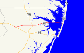
Maryland Route 90 highlighted in red | ||||
| Route information | ||||
| Maintained by MDSHA | ||||
| Length: | 11.83 mi[1] (19.04 km) | |||
| Existed: | 1971 – present | |||
| Major junctions | ||||
| West end: |
| |||
|
| ||||
| East end: |
| |||
| Location | ||||
| Counties: | Worcester | |||
| Highway system | ||||
| ||||

Maryland Route 90 (MD 90) is a state highway in the U.S. state of Maryland. Known as the Ocean City Expressway, the state highway runs 11.83 miles (19.04 km) from U.S. Route 50 (US 50) near Whaleyville to MD 528 in Ocean City. MD 90 is a two-lane expressway that provides one of the main access routes to Ocean City, especially the northern part of the resort, and thus sees heavy seasonal traffic. The highway was constructed from Ocean City starting in 1970. The state highway was opened west to MD 589 in 1972 and to US 113 in 1975. MD 90 was completed west to US 50 in 1976.
Route description
MD 90 begins at a partial directional interchange with US 50 (Ocean Gateway) east of Whaleyville. There is no access from westbound MD 90 to eastbound US 50 or from westbound US 50 to eastbound MD 90. MD 90 heads east as a two-lane undivided freeway with rumble strips within the painted median. Headlight use is required at all times. After passing under MD 346 (Old Ocean City Boulevard) with no access, the state highway crosses over Church Branch. MD 90 crosses over the Snow Hill Line of the Maryland and Delaware Railroad before reaching a partial cloverleaf interchange with US 113 (Worcester Highway). After passing over MD 575 (Worcester Highway), the old alignment of US 113, with no access, the state highway becomes divided with a narrow guardrail median barrier.[1][2]
MD 90 continues east through Ocean Pines, where the highway has a diamond interchange with MD 589 (Racetrack Road) and passes over Ocean Parkway within that community. The median barrier ends and the state highway becomes an undivided highway again immediately before crossing the St. Martin River on a long bridge. A median returns right after the bridge ends at Isle of Wight, where MD 90 has an at-grade signalized intersection with St. Martins Neck Road and the entrance to Isle of Wight Nature Park. MD 90 becomes undivided again for the Assawoman Bay Bridge over Assawoman Bay. After that bridge, the state highway expands to four lanes with a Jersey barrier for a short distance before its terminal intersection with MD 528 (Coastal Highway) at 62nd Street in Ocean City.[1][2]
MD 90 is a part of the main National Highway System for its entire length.[3]
History

Construction on MD 90 began in 1970 with the construction of the bridges over the St. Martin River and Assawoman Bay, which were completed in 1970 and 1971, respectively.[4][5][6] The state highway was completed and opened between MD 528 and MD 589 in 1972.[7] Construction west to US 113 commenced in 1973 and west to US 50 in 1974.[8][9][10][11] MD 90 was extended west to US 113, which at the time followed today's MD 575, in 1975.[12] The state highway was completed when the highway opened between US 50 and US 113 in 1976.[13][14] MD 90's present interchange with US 113 was constructed in 1976.[15] However, the interchange remained unused until US 113 was relocated as a four-lane divided highway from Berlin north past MD 90 in 2000.[16][17][18] The interchange ramp with MD 575 was closed and removed shortly after the new interchange opened.[17] Mayor Rick Meehan of Ocean City is currently pushing for dualization of the MD 90 bridge, stating that it "is the quicker way in and out of town, especially if you look at all the development that has taken place along the Route 50 corridor." He also stated that dualization is good for the route for evacuation purposes.[19]
Junction list
The entire route is in Worcester County.
| Location | mi [1] | km | Destinations | Notes | |
|---|---|---|---|---|---|
| Whaleyville | 0.00 | 0.00 | Western terminus; eastbound exit from and westbound entrance to US 50 | ||
| Friendship | 4.03 | 6.49 | Partial cloverleaf interchange | ||
| Ocean Pines | 6.01 | 9.67 | Diamond interchange | ||
| St. Martin River | 8.42– 9.21 | 13.55– 14.82 | St. Martin's River Bridge | ||
| | 9.47 | 15.24 | St. Martins Neck Road north – Bishopville | At-grade signalized intersection | |
| Assawoman Bay | 9.94– 11.38 | 16.00– 18.31 | Assawoman Bay Bridge | ||
| Ocean City | 11.83 | 19.04 | Eastern terminus; at-grade signalized intersection | ||
| 1.000 mi = 1.609 km; 1.000 km = 0.621 mi | |||||
See also
 Maryland Roads portal
References
- 1 2 3 4 Highway Information Services Division (December 31, 2013). Highway Location Reference. Maryland State Highway Administration. Retrieved 2010-09-20.
- Worcester County (PDF)
- 1 2 Google (2010-04-09). "Maryland Route 90" (Map). Google Maps. Google. Retrieved 2010-04-09.
- ↑ National Highway System: Maryland (PDF) (Map). Federal Highway Administration. October 1, 2012. Retrieved 2012-10-30.
- ↑ Maryland State Roads Commission (1970). Maryland: Official Highway Map (Map). Baltimore: Maryland State Roads Commission.
- ↑ Federal Highway Administration (2012). "NBI Structure Number: 100000230020010". National Bridge Inventory. Federal Highway Administration.
- ↑ Federal Highway Administration (2012). "NBI Structure Number: 100000230021010". National Bridge Inventory. Federal Highway Administration.
- ↑ Maryland State Highway Administration (1972). Maryland: Official Highway Map (Map). Baltimore: Maryland State Highway Administration.
- ↑ Maryland State Highway Administration (1973). Maryland: Official Highway Map (Map). Baltimore: Maryland State Highway Administration.
- ↑ Federal Highway Administration (2012). "NBI Structure Number: 100000230026010". National Bridge Inventory. Federal Highway Administration.
- ↑ Maryland State Highway Administration (1974). Maryland: Official Highway Map (Map). Baltimore: Maryland State Highway Administration.
- ↑ Federal Highway Administration (2012). "NBI Structure Number: 100000230028010". National Bridge Inventory. Federal Highway Administration.
- ↑ Maryland State Highway Administration (1975). Maryland: Official Highway Map (Map) (1975–76 ed.). Baltimore: Maryland State Highway Administration.
- ↑ Federal Highway Administration (2012). "NBI Structure Number: 100000230031010". National Bridge Inventory. Federal Highway Administration.
- ↑ Maryland State Highway Administration (1977). Maryland: Official Highway Map (Map). Baltimore: Maryland State Highway Administration.
- ↑ Federal Highway Administration (2012). "NBI Structure Number: 100000230032010". National Bridge Inventory. Federal Highway Administration.
- ↑ 5 km SW of Ocean Pines, Maryland, United States (Map). Aerial Map. United States Geological Survey. 1989-04-12. Retrieved 2010-04-09.
- 1 2 Highway Information Services Division (December 31, 2000). Highway Location Reference. Maryland State Highway Administration. Retrieved 2010-09-20.
- Worcester County (PDF)
- ↑ Maryland State Highway Administration (2002). Maryland: Official Highway Map (Map). Baltimore: Maryland State Highway Administration.
- ↑ Russo, Bryan (October 30, 2009). "Mayor Seeks Route 90 Dualization". The Maryland Coast Dispatch. Ocean City, MD: J. Steven Green. Retrieved 2010-02-22.
External links
| Wikimedia Commons has media related to Maryland Route 90. |