Massachusetts Heights
For the uplands of Massachusetts, see Geography of Massachusetts.
| Massachusetts Heights | |
|---|---|
| Neighborhood of Washington, D.C. | |
|
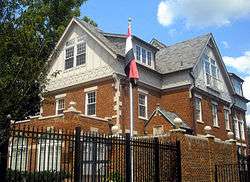
The Embassy of Iraq is located in Massachusetts Heights. | |
 Map of Washington, D.C., with Massachusetts Heights highlighted in red | |
| Coordinates: 38°55′38″N 77°04′09″W / 38.9272°N 77.0692°WCoordinates: 38°55′38″N 77°04′09″W / 38.9272°N 77.0692°W | |
| Country | United States |
| District | Washington, D.C. |
| Ward | Ward 3 |
| Government | |
| • Councilmember | Mary Cheh |
Massachusetts Heights is a small neighborhood in Northwest Washington, DC, dominated by the grounds of the Washington National Cathedral.
The neighborhood is bounded to the north by Woodley Road, to the southwest by Massachusetts Avenue, to the east by 34th Street NW, and to the west by Wisconsin Avenue.
The only residential section of Massachusetts Heights is a small triangular wedge between Massachusetts Avenue and Garfield Street, just adjacent to Observatory Circle and the grounds of the Vice President's Residence. The remainder of the neighborhood is entirely occupied by the Cathedral and its affiliated properties, including St. Albans School.
| Wikimedia Commons has media related to Massachusetts Heights, Washington, D.C.. |
 |
McLean Gardens | Cleveland Park, Washington, D.C. Washington National Cathedral |
Woodley Park | |
| Cathedral Heights | |
|||
| ||||
| | ||||
| Observatory Circle | Woodland-Normanstone Terrace |
This article is issued from Wikipedia - version of the 9/14/2015. The text is available under the Creative Commons Attribution/Share Alike but additional terms may apply for the media files.