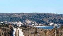
Mattawa, Ontario
| Mattawa | |
|---|---|
| Town (single-tier) | |
| Town of Mattawa | |
 | |
 Mattawa | |
| Coordinates: 46°19′N 78°42′W / 46.317°N 78.700°WCoordinates: 46°19′N 78°42′W / 46.317°N 78.700°W | |
| Country |
|
| Province |
|
| District | Nipissing |
| Government | |
| • Mayor | Dean Backer |
| • MP | Anthony Rota (LPC) |
| • MPP | Victor Fedeli (PC) |
| Area[1] | |
| • Land | 3.66 km2 (1.41 sq mi) |
| Population (2011)[1] | |
| • Total | 2,023 |
| • Density | 553.5/km2 (1,434/sq mi) |
| Time zone | EST (UTC-5) |
| • Summer (DST) | EDT (UTC-4) |
| Postal Code | P0H 1V0 |
| Website |
mattawa |
Mattawa is a town in northeastern Ontario, Canada, at the confluence of the Mattawa and Ottawa Rivers in Nipissing District. Mattawa means "Meeting of the Waters" in Algonquin language. Etienne Brulé and Samuel de Champlain were the first Europeans to pass through this area.
History
The area was first inhabited by native peoples who used the Mattawa River as an important transportation corridor for many centuries. In 1610, Étienne Brûlé[2] and in 1615, Samuel de Champlain were the first Europeans to travel through the Mattawa area.[3] For some 200 years thereafter, it was a link in the important water route leading from Montreal west to Lake Superior. Canoes travelling west up the Ottawa turned left at "the Forks" (the mouth of the Mattawa) to enter the "Petite Rivière" ("Small River", as compared to the Ottawa), before continuing on to Lake Nipissing.[4]
Other notable travellers who passed by Mattawa include: Jean Nicolet in 1620, Jean de Brébeuf in 1626, Gabriel Lallemant in 1648, Pierre-Esprit Radisson and Médard des Groseilliers in 1658, La Verendrye in 1731, Alexander MacKenzie in 1794, and David Thompson in 1812.[3]
Mattawa House was established by the Northwest Company in 1784. In the 1820s and 1830s, the Hudson's Bay Company (after it had merged with the Northwest Company) sent canoe brigades from their Fort Coulonge Post to the Mattawa River junction in order to trade furs. In 1837, a permanent post was established, but was moved to a new site in the centre of present-day Mattawa in 1843. It was subordinate to Fort Témiscamingue and Fort Coulonge, but after the arrival of the telegraph in 1871 and the railroad in 1880, it became the headquarters of the Timiskaming District. As the fur trade diminished and the population grew, the post became a general store, trading merchandise to supply lumbermen. It closed in the early 20th century (1908 or 1912, depending on source).[5][6]
In the 19th century, Mattawa became a hub for the logging industry, which would harvest large untouched stands of white pine in the area and use the Mattawa River to transport logs to sawmills. In 1881, the railroad was built to Mattawa.[2] It was mostly built by French Canadian labourers. After the railroad's completion, some of these labourers and their families settled in Mattawa (and surrounding areas), bringing with them their culture and heritage.[7]
Logging is still an important industry in this region, and nearby provincial parks and wilderness support the camping/hunting/fishing tourism industry in Mattawa today. Mattawa is located on the Canadian Pacific Railway Chalk River subdivision, connecting Smiths Falls and North Bay, with an additional connection to Témiscaming, Quebec.
Mattawa elected Canada's first-ever Black mayor, Firmin Monestime, in 1963. Monestime served as mayor until his death in 1977.[8]
In April 2010, the old Mattawa hospital (visible as the red building in the adjacent image) was demolished amid controversy, since the building was a local landmark for which heritage status was considered. A new Mattawa Hospital had been in service for about a year. The area will be further served by a new regional hospital in nearby North Bay, expected to be completed in January 2011. The old hospital site is expected to be used for the construction of a new secondary school, funded by the Province of Ontario through the Conseil Scolaire de District Catholique Franco-Nord.[9]
Demographics
| Canada census – Mattawa, Ontario community profile | |||
|---|---|---|---|
| 2011 | 2006 | 2001 | |
| Population: | 2023 (1.0% from 2006) | 2003 (-11.8% from 2001) | 2270 (-0.5% from 1996) |
| Land area: | 3.66 km2 (1.41 sq mi) | 3.66 km2 (1.41 sq mi) | 3.66 km2 (1.41 sq mi) |
| Population density: | 553.5/km2 (1,434/sq mi) | 548.0/km2 (1,419/sq mi) | 621.0/km2 (1,608/sq mi) |
| Median age: | 46.4 (M: 45.8, F: 46.9) | 43.7 (M: 43.4, F: 43.9) | 40.2 (M: 39.3, F: 41.4) |
| Total private dwellings: | 888 | 942 | 1016 |
| Median household income: | $31,277 | $27,263 | |
| References: 2011[1] 2006[10] 2001[11] | |||
- Population trend:[12][13][14]
- Population 2011: 2,023
- Population 2006: 2,003
- Population 2001: 2,270
- Population 1996: 2,281
- Population 1991: 2,454
34% of Mattawanians are Francophone,[1] although the seasonal nature of local employment results in population and demographic fluctuations throughout the year.
Attractions
Mattawa is the site of many large wooden statues depicting local historical figures, such as Champlain, Pierre-Esprit Radisson, Médard des Groseilliers, and others. The Mattawa District Museum prominently features a 17 ft (5.2 m) statue of Big Joe Mufferaw, a regional folk hero. The statues are placed widely throughout Mattawa, and in two locations outside the town on nearby Highway 17.[15]
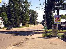
Small shops along Main Street offer unique creations from local artists and craftsmen.
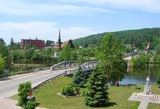
Mattawa provides access to numerous dropping off points for canoeing or boating on the Ottawa River. The river acts as a natural border between the hills of the province of Quebec and Ontario. The Mattawa River flows through the Canadian Shield, and wildlife can often be seen and heard. The area offers fishing, camping, and hiking. There are numerous motels, campgrounds, and retreat centres in and around Mattawa.
Just west is Samuel de Champlain Provincial Park, on the Mattawa River. The park is also home of the Canadian Ecology Centre, an eco-friendly retreat centre that is facilitated to accommodate business retreats. Algonquin Provincial Park can be accessed from the north side in Kiosk or the east side in Brent.
The town and nearby area contain over 200 kilometres (120 mi) of year-round ATV and snowmobile trails, known as the Voyageur Multi Use Trail System (VMUTS).
In 2007, Mattawa and the townships of Bonfield, Papineau-Cameron, Mattawan and Calvin were rebranded as a single Mattawa Voyageur Country tourist region, in order to promote the area.[16]
Voyageur Days
Every summer since 1997, the Mattawa Voyageur Days Festival is held the last weekend (Thursday-Sunday) of July. It is organized by the Town of Mattawa. Concerts take place behind the Museum on Explorer's Point, with many other events and attractions around town. Some of the events include a regional talent night, lumberjack competition, and canoe race. Live music is a large part of the Festival, and has in the past included such notable Canadian musicians as April Wine, Trooper, Saga, Loverboy, Honeymoon Suite, Chuck Labelle, David Wilcox, Peter Frampton, Heart and Tom Cochrane. Up-and-coming artists from inside and outside the region take the stage on the Thursday night.
On the Sunday night, at dusk, there is a traditional choreographed fireworks show.
Mattawa Voyageur Days celebrated its 10th anniversary in July 2007, selling out of its 7,000 admission wristbands before the event had begun. In 2008, Festivals and Events Ontario listed Mattawa Voyageur Days as one of the Top 100 Ontario Festivals.[17]
Musical references
Mattawa is one of the towns mentioned in the popular country music song, "I've Been Everywhere," covered by Hank Snow and Johnny Cash. In late 2013 or early 2014 Blue Rodeo came out with a song called "Mattawa", about a long trip to go there. Likewise, Mattawa is mentioned in the Stompin' Tom Connors song, "Mufferaw Joe," a Canadian folk hero who supposedly "paddled into Mattawa, all the way from Ottawa in just one day."
Media
Radio
Mattawa is served by two low-power AM repeaters of Greater Sudbury's CBC Radio stations, including one FM radio station CJTK-FM:
- AM 1090 - CBON-12, Première Chaîne
- AM 1240 - CBLO, CBC Radio One
- FM 93.9 - CJTK-FM, Christian radio (repeats CJTK-FM-1 North Bay, Ontario).
The town is otherwise served by radio stations from North Bay.
Mattawa's weekly newspaper The Mattawa Recorder has been in publication since 1972. It is owned and published by Tom and Heather Edwards.
Notable people
- Anahareo, wife of writer and conservationist Grey Owl
- Mauril Bélanger, PC, MP (born June 15, 1955) is a former Liberal Member of the Canadian Parliament (1995-2016).
- Lillian Bilsky Freiman, a philanthropist and Zionist.
- Donald Hogarth, politician and mining financier.
- Chuck Labelle, a Franco-Ontarian singer/songwriter
- Dr. Firmin Monestime, Canada's first black mayor.
- Gilbert Parent, former speaker of the Canadian House of Commons
- John C. Major, served as a puisne justice of the Supreme Court of Canada (1992-2005).
See also
References
- 1 2 3 4 "Mattawa census profile". 2011 Census of Population. Statistics Canada. Retrieved 2012-02-09.
- 1 2 Canadian Heritage Rivers System: Mattawa River fact sheet, Ministry of Natural Resources (Online version)
- 1 2 Archeological and Historic Sites Board of Canada
- ↑ Historic Sites and Monuments Board of Canada
- ↑ Ontario Archaeological and Historic Sites Board
- ↑ Elizabeth Browne Losey, "Let Them be Remembered:The Story of the Fur Trade Forts", 1999. ISBN 0-533-12572-3
- ↑ Government of Ontario - Ontario Heritage Trust
- ↑ "Mattawa's Dr. Firmin Monestime Remembered", North Bay Nugget, October 26, 2007.
- ↑ 'North Bay Nugget'.
- ↑ "2006 Community Profiles". Canada 2006 Census. Statistics Canada. March 30, 2011. Retrieved 2012-02-09.
- ↑ "2001 Community Profiles". Canada 2001 Census. Statistics Canada. February 17, 2012. Retrieved 2012-02-09.
- ↑ "Mattawa community profile". 2006 Census data. Statistics Canada. Retrieved 2011-02-16.
- ↑ Canada 2001 Census
- ↑ Canada 1996 Census
- ↑ Mackey, D. "History in the Streets of Mattawa", North Bay Nugget, September 9, 2005. Accessed March 29, 2008.
- ↑ Adams, K. "Mattawa sports a new look", Baytoday.ca, July 17, 2007. Accessed March 28, 2008.
- ↑ Hamilton-McCharles, J. "Voyageur Days among top festivals in Ontario; Organizers booking more acts", North Bay Nugget, March 6, 2008. Accessed March 29, 2008.
External links
| Wikimedia Commons has media related to Mattawa, Ontario. |
 |
Mattawan | Ottawa River |
| |
| Papineau-Cameron | |
Papineau-Cameron | ||
| ||||
| | ||||
| Papineau-Cameron |
| Cities |  | |
|---|---|---|
| Towns | ||
| Townships | ||
| First Nations | ||
| Indian reserves | ||
| Unorganized areas | ||
| Local services boards | ||
| ||