Mavkovychi
| Mavkovychi Ма́вковичі | |
|---|---|
| village | |
 | |
 Mavkovychi | |
| Coordinates: UA 49°44′50″N 23°41′51″E / 49.74722°N 23.69750°ECoordinates: UA 49°44′50″N 23°41′51″E / 49.74722°N 23.69750°E | |
| Country |
|
| Province |
|
| District |
|
| Established | 1490 |
| Area | |
| • Total | 1,19 km2 (46 sq mi) |
| Elevation/(average value of) | 267 m (876 ft) |
| Population | |
| • Total | 1,190 |
| • Density | 999,16/km2 (258,780/sq mi) |
| Time zone | EET (UTC+2) |
| • Summer (DST) | EEST (UTC+3) |
| Postal code | 81550 |
| Area code | +380 3231 |
| Website | село Мавковичі (Ukrainian) |
Mavkovychi (Ukrainian: Ма́вковичі)–- village (selo) in the Lviv Oblast (province) of western Ukraine. It is located in the Horodotsky Raion (Horodok Raion), placed along the way Horodok - Velykyi Liubin. Local government —Kernytska village council. [1] The first mention of Mavkovychi dates from the year 1490.[2] Then the village has received Magdeburg rights.
The village Mavkovychi is situated in the 31 kilometres (19 mi) from the regional center Lviv, 7 kilometres (4.3 mi) from the district center Horodok and 4 kilometres (2.5 mi) from Velykyi Liubin.[3]
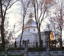
In the village there are church of the Nativity of the Most Holy Theotokos. The first stone cross was consecrated in 1898, and the church was built in 1902.
References
- ↑ Керницька сільська рада (Ukrainian)
- ↑ (Ukrainian)
- ↑ DELLA
External links
- weather.in.ua
- Ukrainian: Городоцьке Благочиння
- Ukrainian: Легендарне село Мавковичі
- Ukrainian: Нарис з історії села
Literature
- Ukrainian: History of Towns and Villages of the Ukrainian SSR, Lvov region. – К. : ГРУРЕ, 1968 р.
| Cities | ||
|---|---|---|
| Urban-type settlements |
| |
| Villages |
| |
This article is issued from Wikipedia - version of the 8/30/2016. The text is available under the Creative Commons Attribution/Share Alike but additional terms may apply for the media files.