McNutt, Mississippi
| McNutt, Mississippi | |
|---|---|
| Unincorporated community | |
 McNutt, Mississippi  McNutt, Mississippi | |
| Coordinates: 33°38′50″N 90°22′20″W / 33.64722°N 90.37222°WCoordinates: 33°38′50″N 90°22′20″W / 33.64722°N 90.37222°W | |
| Country | United States |
| State | Mississippi |
| County | Leflore |
| Elevation | 138 ft (42 m) |
| Time zone | Central (CST) (UTC-6) |
| • Summer (DST) | CDT (UTC-5) |
| ZIP code | 38952 |
| Area code(s) | 662 |
| GNIS feature ID | 684207[1] |
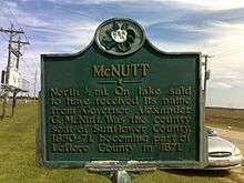
McNutt Historical Marker located on Mississippi Highway 442
McNutt is an unincorporated community located in Leflore County, Mississippi. McNutt is located west of Schlater, just off Mississippi Highway 442.
It is part of the Greenwood, Mississippi micropolitan area..
References
Municipalities and communities of Leflore County, Mississippi, United States | ||
|---|---|---|
| Cities | 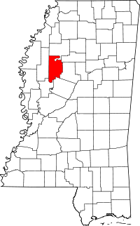 | |
| Towns | ||
| CDP | ||
| Unincorporated communities | ||
| Ghost town | ||
| Footnotes | ‡This populated place also has portions in an adjacent county or counties | |
This article is issued from Wikipedia - version of the 7/30/2016. The text is available under the Creative Commons Attribution/Share Alike but additional terms may apply for the media files.