Meadowvale, Ontario
| Meadowvale | |
|---|---|
| Neighbourhood | |
|
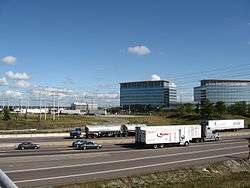
Mississauga Road overpass at Highway 401, in the industrial area of Meadowvale. | |
| Coordinates: 43°37′43″N 79°43′42″W / 43.62861°N 79.72833°W | |
| Country | Canada |
| Province | Ontario |
| Regional municipality | Peel |
| City | Mississauga |
| Time zone | EST (UTC-5) |
| • Summer (DST) | EDT (UTC-4) |
| Forward sortation area | L5N |
| Area code(s) | 905 and 289 |
| NTS Map | 030M12 |
| GNBC Code | FDHXD |
Meadowvale is a neighbourhood located in the northwestern part of Mississauga, just west of Toronto, Ontario, Canada. In the 19th and early 20th centuries, it was a village in Toronto Township. In the 1970s, Meadowvale was selected to be the name of a new town community for the newly (1974) incorporated City of Mississauga; the name was applied to a development a few miles west along Derry Road.
Geography
Meadowvale is located at 43°45′0″N 79°48′0″W / 43.75000°N 79.80000°W. The community is situated near the Credit River which lies to the east. Pine forests including other types of trees are along the Credit Valley which covers most of the central part of the subdivision. Another creek named Levi Creek runs to the south and southwest and is a tributary of the Credit lying to the south.
The rough boundaries of Meadowvale are: Ninth Line, Mavis Road, Highway 401, Britannia Road.[1]
Meadowvale has two lakes, Aquitaine and Wabukayne, both of which were largely man-made. A system of parks and trails connects the two lakes, which are located about 1.5 kilometres apart.
Demographics
- Population of Meadowvale as a whole
- 1996: 63,095[1]
- 2001: 84,225
- 2006: 99,700 (estimated population)
- 2009: 104,540
- For planning purposes the city of Mississauga is divided into 24 districts. Here are the estimated 2009 populations for districts which comprise the area known as Meadowvale.
- Meadowvale 43,500
- Lisgar 34,500
- Meadowvale Village 26,500
- Percentage visible minority population[1]
- 1996: 22.6%
- 2001: 31.6%
- 2009: 46.6%
- Breakdown of visible minority population as of 2009
- South Asian 24.3%
- Black 11.7%
- Chinese 6.4%
- Filipino 5.2%
- Arab/West Asian 3.8%
- Latin American 3.2%
History
The village of Meadowvale was established in the 1820s by Irish immigrants from New York state.[2] In the village's early years, the main industry was milling, with the mills drawing power from the Credit River.[3] Gooderham and Worts owned and operated many businesses in the village in the 1860s and 1870s, including a mill.
The multi-lane, controlled access MacDonald-Cartier Freeway, also known as Kings Highway 401, was opened south of Meadowvale Village in 1959. In 1968, Meadowvale was incorporated into the new Town of Mississauga. In the 1970s, farmland west of the original Meadowvale Village was developed into a series of subdivisions that make up much of present-day Meadowvale. This area has continued to expand ever since, and now fills most of the northwest corner of Mississauga.
Meadowvale village is located adjacent to the largest business park area in Mississauga, with the second largest being located in between Meadowvale Village and Meadowvale along the Highway 401 corridor, where numerous major corporations have recently located their offices, factories and research and development facilities, including:
- Wal-Mart Canada - Retailer
- Chrysler Canada - Car
- Siemens - Electronics
- GlaxoSmithKline - Pharmaceuticals
- Magna International - Auto Parts
- Microsoft - Software
- Tech Data - Computer parts distributor
- Biovail - Bio-medical
- DuPont - Chemicals
- Fujitsu - Computer
- Mitutoyo - Measuring Equipment
- Sandvik - Materials and Metallurgy
- FANUC Robotics - CNC controllers
- Snap-on - Tools
- Purolator Courier - Courier
- Royal Bank of Canada - Bank
- Maple Leaf Foods - Food Manufacturer
- Tech Data - IT components distributor
- Mary Kay - Cosmetics
- Royal LePage Meadowtowne Realty
- D-Link - Computer/Networking Parts
- Vivid Entertainment - Adult services
- Ashley Madison - Dating Website
In recognition of its many historical buildings, Meadowvale Village was recognized as Ontario’s first Heritage Conservation District in 1980.[3] To reduce traffic through the village, the Derry Road by-pass was built in the mid-1990s. Located about one kilometre north of the Old Derry Road, the new Derry Road is a major east-west traffic artery running from Mississauga Road to Mavis Road.
In June 2006, Meadowvale found itself in an international media spotlight, as a number of former Meadowvale Secondary School students were among those charged in an alleged terror plot to bomb well-known Canadian buildings and assassinate political leaders.[4]
Transportation
Freeway
Meadowvale is accessed via Highway 401 via Winston Churchill Boulevard, Mississauga Road, or Mavis Road.
Meadowvale's highway on-ramps are among the largest in North America, the largest on-ramp comprising 8 lanes in each direction.
Tollway
Traveling westbound, Highway 407 bypasses Meadowvale along its northern border before continuing south to Oakville.
Major thoroughfares
Winston Churchill Blvd., Erin Mills Parkway and Mavis Road are major north-south roads that connect Meadowvale to the rest of Mississauga. Derry and Britannia Roads are major east-west roads.
Interurban transit
Meadowvale GO Station serves as a hub for GO Transit operations. It is an intersection point for GO Transit in the north west of the GTA. The station is serviced by one rail/bus line and 3 bus lines. The station offers express hourly service to the two largest transit hubs in the GTA, York University and Union Station.
- The station is located along the Milton Line rail line, which offers rush hour train service to downtown in the morning and from downtown in the evening. Bus service is provided for the reverse-commuter and during non-rush hour periods.
- York University Express along Highway 407. With some service via Bramalea GO Station and Highway 407 & Hurontario.
- Milton 401 service - Milton via Meadowvale to Yorkdale and Finch Termainal.
- University of Guelph Service to York University via Meadowvale, Highway 407 & Hurontario and Bramalea GO Station.
GO Transit buses arriving from Milton, pass by Meadowvale Town Centre on their way to Meadowvale GO Station.
MiWay offers a shuttle bus service to and from Meadowvale GO Station during rush hour.
Lisgar GO Station, which opened in September 2007,[5] provides service to commuters living in newly developed areas in the western portion of Meadowvale. Construction of a GO Transit bus garage at Alpha Mills Road and Mississauga Road has also been proposed. (completed in 2009)
Local transit
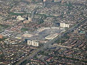
Meadowvale Town Centre is MiWay's third largest terminal. It is the second largest in Mississauga, after the main terminal, Square One.
MiWay offers local transit, as well as service to Islington Subway Station and Square One.
Pearson Airport is serviced indirectly via either the 42 Derry Road bus or Square One bus terminal.
Trails
Meadowvale also has a series of bike and walking trails,[6] offering access to, among other things, schools, parks, the Meadowvale Town Centre and the Meadowvale Community Centre.
Sports and recreation
Meadowvale is the former home to Burlington Twins of the Intercounty Baseball League from 2009-2010 before moving to Burlington. Meadowvale is also home to the minor hockey team the "Meadowvale Hawks", which is part of the Mississauga Hockey League (MHL).
Notable people from or residing in Meadowvale
- Billy Talent band members Ian D'Sa, Aaron Solowoniuk, Benjamin Kowalewicz, and Jonathan Gallant.
- Joel Gibb, lead vocalist of the indie pop band The Hidden Cameras
References
- 1 2 3 Portraits of Peel - Meadowvale
- ↑ HISTORY : : Mississauga heritage Foundation
- 1 2 Toronto : Communities of Mississauga | WHERE.ca
- ↑ Alleged Toronto bomb plot Timeline: Key events inMeadowvale the case - CBC.ca
- ↑ "New GO stations". GO Transit. Archived from the original on 2008-08-02. Retrieved 2008-10-01.
- ↑ Lake Aquitaine Bike Path
External links
| Wikimedia Commons has media related to Meadowvale. |
 |
Brampton | | ||
| Milton | |
Meadowvale Village / Derry West | ||
| ||||
| | ||||
| Erin Mills, Streetsville |
Coordinates: 43°37′43″N 79°43′42″W / 43.62861°N 79.72833°W