Mechanicsville, Virginia
| Mechanicsville, Virginia | |
|---|---|
| CDP | |
| Nickname(s): The Ville | |
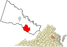 Location in Hanover County and the state of Virginia. | |
| Coordinates: 37°37′9″N 77°21′18″W / 37.61917°N 77.35500°WCoordinates: 37°37′9″N 77°21′18″W / 37.61917°N 77.35500°W | |
| Country | United States |
| State | Virginia |
| County | Hanover |
| Area[1] | |
| • Total | 28.5 sq mi (73.8 km2) |
| • Land | 28.4 sq mi (73.6 km2) |
| • Water | 0.1 sq mi (0.3 km2) |
| Population (2010) | |
| • Total | 36,348 |
| • Density | 1,300/sq mi (490/km2) |
| Time zone | Eastern (EST) (UTC-5) |
| • Summer (DST) | EDT (UTC-4) |
| Area code(s) | 804 |
Mechanicsville is a census-designated place (CDP) in Hanover County, Virginia, United States. The population was 36,348 during the 2010 census.
History
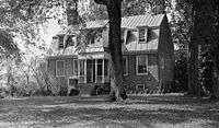
The area was settled by English colonists starting in the 17th century. Rural Plains, also known as Shelton House, is a house built in the early decades of the eighteenth century. It is now owned and operated by the National Park Service as one of the sites of the Richmond National Battlefield Park.
In "Old Mechanicsville" stands a stone windmill, now a landmark in the village. The building was constructed as a "Heritage Bank" branch office in the 1970s. In 2007-2008, it was restored and enlarged by a new bank occupancy. The "windmill" is decorative and driven by an electric motor.
Mechanicsville is associated with several major battles and numerous minor skirmishes during the American Civil War.
In addition to Rural Plains, Clover Lea, Cold Harbor National Cemetery, Cool Well, Hanover Meeting House, Hanover Town, Immanuel Episcopal Church, Laurel Meadow, Locust Hill, Oak Forest, Oakley Hill, Selwyn, and Spring Green are listed on the National Register of Historic Places.[2]
Beaver Dam Creek
The first was the Battle of Beaver Dam Creek, which began on June 26, 1862. Confederate Gen. A.P. Hill launched a series of assaults against the Union Army Union Maj. Gen. Fitz John Porter's army positioned along Beaver Dam Creek, just east of Mechanicsville. Union forces repulsed the Confederate attacks and afterward withdrew to a new position along Boatswain Creek near Gaines' Mill. The Beaver Dam Creek engagement was the second in the series of American Civil War battles known as the Seven Days Battles. A small portion of the battlefield has been preserved as part of the Richmond National Battlefield Park, a park area administered by the National Park Service.
Gaines' Mill
The Battle of Gaines' Mill was the third of the Seven Days Battles, occurring just east of Mechanicsville. A portion of the battlefield has been preserved at the "Watt House" as part of the Richmond National Battlefield Park, a park area administered by the National Park Service.
Cold Harbor
The other major clash near Mechanicsville was the Battle of Cold Harbor, the final battle of Union Lieut. Gen. Ulysses S. Grant's 1864 Overland Campaign. This was fought over the same ground as the Battle of Gaines' Mill. The area identified as part of the battlefield for "Second Cold Harbor" stretches from near the intersection of Walnut Grove Road and Mechanicsville Turnpike to "Turkey Hill" near the Rt. 156 crossing of the Chickahominy River. An area of the battlefield which saw heavy casualties and a nearby post-war National cemetery are preserved as historic monuments.
Demographics
| Historical population | |||
|---|---|---|---|
| Census | Pop. | %± | |
| 1970 | 5,189 | — | |
| 1980 | 9,269 | 78.6% | |
| 1990 | 22,027 | 137.6% | |
| 2000 | 30,464 | 38.3% | |
| 2010 | 36,348 | 19.3% | |
As of the census of 2000, there were 30,464 people, 11,607 households, and 8,832 families residing in the CDP. The population density was 1,073.3 people per square mile (414.5/km²). There were 11,915 housing units at an average density of 419.8/sq mi (162.1/km²). The racial makeup of the CDP was 90.80% White, 6.40% African American, 0.43% Native American, 0.90% Asian, 0.01% Pacific Islander, 0.49% from other races, and 0.97% from two or more races.Hispanic or Latino of any race were 1.18% of the population.There were 11,607 households out of which 39.4% had children under the age of 18 living with them, 62.7% were married couples living together, 10.6% had a female householder with no husband present, and 23.9% were non-families. 19.7% of all households were made up of individuals and 7.4% had someone living alone who was 65 years of age or older. The average household size was 2.61 and the average family size was 3.00. In the CDP the population was spread out with 26.9% under the age of 18, 5.7% from 18 to 24, 33.6% from 25 to 44, 22.5% from 45 to 64, and 11.2% who were 65 years of age or older. The median age was 36 years. For every 100 females there were 92.8 males. For every 100 females age 18 and over, there were 88.4 males.The median income for a household in the town was $57,032, and the median income for a family was $62,209. In the 23116 zip code, however, the median income is $107,000. Males had a median income of $41,338 versus $30,217 for females. The per capita income for the town was $24,068. 3.3% of the population and 2.8% of families were below the poverty line. Out of the total people living in poverty, 3.6% are under the age of 18 and 4.1% are 65 or older.
Notable residents
- Jason Mraz, Singer/songwriter
- Stacy Tutt, NFL fullback
- Bill Bolling, Republican Lieutenant Governor of Virginia
- Kevin Grubb, NASCAR driver
- Wayne Grubb, NASCAR crew chief and former driver
- Tim Menzies, Singer/songwriter
- Mary Ann Redmond, Singer/songwriter
- Billy Parker, Arena Football League defensive specialist for the New York Dragons.
- Zuriel Smith, New England Patriots wide receiver[3]
- Matt Taylor, bassist in the band Motion City Soundtrack[4]
- Tony Thaxton, drummer in the band Motion City Soundtrack[4]
- Wes Freed, artist and musician
- Willie Adler, guitarist for Lamb of God
References
- ↑ "US Gazetteer files: 2010, 2000, and 1990". United States Census Bureau. 2011-02-12. Retrieved 2011-04-23.
- ↑ National Park Service (2010-07-09). "National Register Information System". National Register of Historic Places. National Park Service.
- ↑ Zuriel Smith Profile at dallascowboys.com
- 1 2 Our Late Night with Conan O'Brien
External links
Municipalities and communities of Hanover County, Virginia, United States | ||
|---|---|---|
| Town | 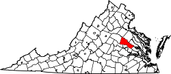 | |
| CDPs | ||
| Unincorporated communities | ||