Meganisi
| Meganisi Μεγανήσι | |
|---|---|
|
Vathy Harbor | |
 Meganisi | |
|
Location within the region 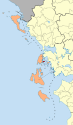 | |
| Coordinates: 38°40′N 20°47′E / 38.667°N 20.783°ECoordinates: 38°40′N 20°47′E / 38.667°N 20.783°E | |
| Country | Greece |
| Administrative region | Ionian Islands |
| Regional unit | Lefkada |
| Area | |
| • Municipality | 22.356 km2 (8.632 sq mi) |
| Highest elevation | 309 m (1,014 ft) |
| Lowest elevation | 0 m (0 ft) |
| Population (2011)[1] | |
| • Municipality | 1,041 |
| • Municipality density | 47/km2 (120/sq mi) |
| Time zone | EET (UTC+2) |
| • Summer (DST) | EEST (UTC+3) |
| Postal code | 310 83 |
| Area code(s) | 26450 |
| Vehicle registration | EY |
| Website | www.meganisi.gr |

Meganisi (Greek: Μεγανήσι, literally "big island") is a Greek island and municipality immediately to the east-southeast of the island of Lefkada. The municipality includes the offshore islands of Skorpios (pop. 2 persons) and Sparti. The municipality has an area of 22.356 km2.[2] Its total population was 1,041 at the 2011 census.
The island has three villages: the central village of Katomeri (pop. 492) and the ports of Vathy (145) and Spartochori (453 inhabitants). There is also a harbour at Atheni Bay used mainly by fishing boats. Meganisi is connected with Lefkada by a car ferry service from Vathy and Spartochori. Meganisi has a school, a lyceum (middle school), an ATM, churches and a few squares (plateies). The island has no secondary school, so pupils attend the nearby school in Nydri, on Lefkada.
Some researchers, including Wilhelm Dörpfeld estimate that Meganisi was the Homeric island of Krocylea, which was part of Odysseus' kingdom.
Municipality
Municipal districts
- Katomeri
- Spartochori
- Vathy
Islands
- Skorpios - private island
- Sparti
Historical population
| Year | Island population |
|---|---|
| 1981 | 1,149 |
| 1991 | 1,246 |
| 2001 | 1,092 |
| 2011 | 1,041 |
See also
References
- ↑ "Απογραφή Πληθυσμού - Κατοικιών 2011. ΜΟΝΙΜΟΣ Πληθυσμός" (in Greek). Hellenic Statistical Authority.
- ↑ "Population & housing census 2001 (incl. area and average elevation)" (PDF) (in Greek). National Statistical Service of Greece.
External links
- Official website (English) (Greek)
- News from Meganisi (Greek)
- Ellomenos on GTP Travel Pages (in English and Greek)
| Regional unit of Corfu |  | |
|---|---|---|
| Regional unit of Cephalonia | ||
| Regional unit of Ithaca | ||
| Regional unit of Lefkada | ||
| Regional unit of Zakynthos | ||
| ||