Othonoi
| Othonoi Οθωνοί | ||
|---|---|---|
|
Othoni island | ||
| ||
 Othonoi | ||
|
Location within the regional unit [[File:DE Othonon.svg <ref>Book: Ιόνιον άκρων, εκδόσεις ΈΨΙΛOΝ. 2000, ISBN 960-7062-99-X (page 30)</ref>|250x250px|center]] | ||
| Coordinates: 39°51′N 19°24′E / 39.850°N 19.400°ECoordinates: 39°51′N 19°24′E / 39.850°N 19.400°E | ||
| Country | Greece | |
| Administrative region | Ionian Islands | |
| Regional unit | Corfu | |
| Municipality | Corfu | |
| • Municipal unit | 10.078 km2 (3.891 sq mi) | |
| Highest elevation | 393 m (1,289 ft) | |
| Population (2011)[1] | ||
| • Municipal unit | 392 | |
| • Municipal unit density | 39/km2 (100/sq mi) | |
| Time zone | EET (UTC+2) | |
| • Summer (DST) | EEST (UTC+3) | |
| Postal code | 49100 | |
| Area code(s) | 26630 | |
| Website | ||
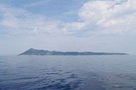
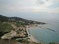
Othonoi or Othoni (Greek: Οθωνοί, Italian: Fanò or Othoni) is a Greek island and the westernmost point of Greece. It is a former community of the Ionian Islands. Since the 2011 local government reform it is part of the municipality of Corfu, of which it is a municipal unit.[2] The municipal unit has an area of 10.078 km2.[3] It is located northwest of Corfu. Population 392 (2011). It is the biggest of the Diapontia Islands. In the 19th century the island used to be the capital of the Diapontia Islands municipality, which also included nearby islands of Ereikoussa, Mathraki,islets and rocks of Diakopo, Diaplo, Karavi, Kastrino, Leipso, Ostrako, Plaka, Plateia and Tracheia. Othoni is about 47 n.miles from Santa Maria di Leuca cape, Italy.[4][5]
Name
The first name according to ancient texts (Hesychius, 3rd cent. BC) was "Othronos" (Οθρονός), "Othronoi" (Οθρωνοί) and by Procopius seams to be "Othoni" (Οθωνή) (6th c.). According to Pliny (1st cent.) was "Thoronos" (Θόρονος). Other names were "Fidonisi" (Snake island) because of the many snakes that are said to have invaded the island, and "Fano" (Lamp) which is used in international charters and by the Italians because of the lighthouse that it is on the island. There are also views that came from the word "screen" (Greek:Οθόνη) as "Othones" seems that the local seamen call the sails of their sailing boats.[6]
History
At the beginning of the second millennium, the island was conquered alternatively Franks (the 11th century) and the Venetians (12th century), often attacked by pirates of Barbary and Algeria. Since the end of 1383 until 1386 the domination of Corfu brought by Charles III of Naples. In his letter he stated that on April 19, 1383 granted the usufruct of Othoni Ereikoussa, Mathraki, Diapolo and Vido, the knight Theodore Skaliti as fief. In 1537, the Turkish fleet under the command of Greek origin pirate and admiral Hayreddin Barbarossa massacred the inhabitants of Othoni island after a long battle. In Stavros district at an altitude of 217 m. a white stone cross exists until today to commemorate that event.


The last settlers of Othoni apparently came from Paxos and Ioannina, Parga and the region of Epirus. Dated after the Battle of Nafpaktos in 1571,when the Turkish fleet was destroyed and the islanders began to move more safely. After the last movement, the residents of Othoni island colonized the two other small islands,Ereikoussa and Mathraki. In 1815, the English conquered Othonoi and as is said, sent to the island sick soldiers to recover because of the good climate that prevailed. The Treaty signed on March 29, 1864 between the three powers (England, France, Russia) and the Kingdom of Greece, the Ionian Islands -and Diapontia islands- passed definitively to Greek sovereignty on 21 May. On October 5, 1864, the Ionian Parliament realized the purpose of the convocation solemnly acting union with Greece one and indivisible state under the king, George I of Greece.[7] From 1869 until 1912 Othoni, Ereikousa and Mathraki formed the municipality of 'Diapontia Nisia with Othoni as capital.[8]
Naval history
Othoni have achieved big naval and maritime history as men crowd the island and the surrounding islands were involved in shipping (1880-1990). It is significant that there is no family without a sailor. Also, many Othoniotes were senior crews in war ships ships. Main maritime occupations was sailor, boatswain, master or engineer of any class etc. A lot of Othoniotes were ship owners as they had a large number of yachts and commercial steamships traveling to many Mediterranean ports.[9] Unfortunately, within these decades of history that wrote Othoniotes at sea, there were some victims because of several wrecks due to sloppiness and carelessness of those responsible in the last century.[10][11]
Mythology
According to a legend, in the ancient times it was the island of nymph Calypso (mythology) who lived in a large cave. Odysseus fell in love and remained like a prisoner there for seven years. Homer called thιs island Ogygia. Due to his scriptures there was a strong scent of cypress on Ogygia island. Othonoi is a place with many of these trees. Odysseus left the island by a raft and he sank on Scheria the island of Corfu . This is an extra element that justifies the legend of Othonoi being Ogygia, because of the short distance that separates the two islands.[12]
According to Hesychius, after the Trojan War, Elephenor, king of Avantes from Euboea fled to the island after the fall of Troy, to atone as he had killed his grandfather, Abas.

Economy
Most Othoniotes (local dialect: Thoniotes) have migrated to Corfu, Athens and abroad (especially to the USA) because of the unemployment and few exploitable resources (1900-1960).The main work was the olive and oil production. Most men of that time were involved in nautical professions (sailor, bosun, carpenter, captain, skipper etc.) and worked on commercial and war ships which were operating in every part of earth. Main occupation of current residents is tourism, fishing and olive production. Previously there has been significant cultivation of vines, the beekeeping and livestock.[14]
Settlements
|
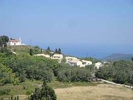 Horio, the first settlement of Othoni island (and Saint George church)
|
Visitor attractions
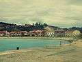
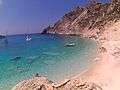
To the west of the island, near the Aspri ammos beach (accessible only by boat), is the cave of Calypso. There are many old churches like the Holy Trinity church (1892) at Ammos,Virgin Mary (Panagia) church near Stavros, Saint George church (about 1890) at Chorio, Agia Paraskevi and the old stone mill in Damaskatika. At Ammos district is the school of Othoni (1912). At the northeast end of Kastri cape hilltop at an altitude of 100 m near the ruins of the Venetian fortress is the lighthouse of Othoni which was built in 1872. The port of Ammos, which is the most populous district is one of the schools of Othoni (1912) and small guesthouses, restaurants, rent-a-bike store, cafes, police station, community clinic with ambulance and port authority.[16]
Beaches
Most beaches on the island are accessible by boat, including Ammos, Molos, Kamini, Kanoula, Kontoskes, Rogi, Fyki, Xilosermi, and Aspri Ammos. It is a well known island for underwater photography because of the peculiar geomorphology of the seabed and the many caves. Other points of interest are the Moshopontikas, Xylosermi, Fyki bay (where there is the sunken wreck of Sarah ship). Othoni was frequently visited by the French naturalist Jacques Cousteau and his exploratory vessel Calypso.


Trails
The traditional trail was created and used by the first inhabitants, and was subsequently reopened by the municipality and private initiatives. Locals and visitors can use the trail to reach almost every neighborhood and part of the island on foot, as well as Imerovigli (Merovigli), the highest peak of the island, with a height of over 390 metres (1,280 ft), with views of the other Diapontia Islands, Ionian sea and Adriatic sea.[17]
Nature
Flora
The island is almost completely covered by trees which produce a small species of olive, the "Elea the cherry" (Olea microcarpa), commonly Lianolia or ladoelia, with a high content of high quality oil, which is common in all the Ionian Islands. It was densely planted during Venetian rule, so most are aged 300–400 years exceeding a height of 7 metres (23 ft).
There are cypresses and fruit trees on almost all mountain slopes. The tall mulberry (or Skamnia) and fig (or Skeria) are found in nearly all districts and gardens that host many species of fruit and vegetables, and features large cabbage called by Othoniotes cramps, as in Cyprus. Most houses have, instead of tents or sheds, pergolas with vines or pergoulies. Oregano, sage and many other herbs.
Fauna
Othoni is the first migratory bird station in southeastern Europe from Libya, especially for turtle doves. There are also grouse and snipe (xilokotes) during the winter months, and Petritis falcons, the European bee-eater birds, martins, ravens and several species of eagles.
There are several hares and rabbits. The most common species of reptile is the viper (Vipera ammodytes or astritis).
Marine mammals have been observed off the island's coast, including the bottlenose dolphin, at least three species of sharks (including white shark), while sporadically near the cave of Calypso there have been monk seals. also found almost all varieties of marine fauna, such as the white sea bream, red mullet, the snapper, the grouper, the bumpkin (weighing up to 30 pounds), octopus, moray, the stingray, lobster. Remarkable is the presence of barnacles and sea urchins. Zooplankton is in small coves of the island and especially in seaweed is abundant at night, and when the sea is calm, the plankton illuminates the sea bed.
Transport
The island is accessible by boat with regular services from Corfu port and Agios Stefanos Avliotes. There is a port in Avlakia district (with fishing port), for several small private yachts and boats.The island has a heliport for emergencies. Asphalt roads are available on many parts of the island, about 12 kilometres (7.5 mi) of which are extended to settlements. There is complete electrification and a telephone network with Internet access.
Notable greek politicians visited Othoni
|
Gallery
-
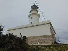
Othoni's lighthouse
-

Koukouli rock
-
%2C_Chorio%2C_Othoni_island.jpg)
Sunset, Chorio
-
Ammos port
-

Virgin Mary orthodox church
-
Aspri ammos beach
-
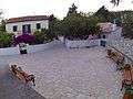
Chorio square
-
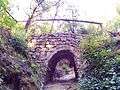
One of the old stone bridges of Othoni
-
Ammos district
-

Old mile, Damaskatika district
-
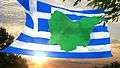
Othoni flag
References
- ↑ "Απογραφή Πληθυσμού - Κατοικιών 2011. ΜΟΝΙΜΟΣ Πληθυσμός" (in Greek). Hellenic Statistical Authority.
- ↑ Kallikratis law Greece Ministry of Interior (Greek)
- ↑ "Population & housing census 2001 (incl. area and average elevation)" (PDF) (in Greek). National Statistical Service of Greece.
- ↑ "Information about Othonoi". http://www.othonoi.gr. External link in
|website=(help) - ↑ "chiodofisso.it (distance between Othoni and Italy)". http://www.othonichiodofisso.it/. External link in
|website=(help) - ↑ Book: Ιόνιον άκρων, εκδόσεις ΈΨΙΛOΝ. 2000, ISBN 960-7062-99-X. (page 19)
- ↑ Book: Ιόνιον άκρων, εκδόσεις ΈΨΙΛOΝ. 2000, ISBN 960-7062-99-X (pages 25-30)
- ↑ Book: Ιόνιον άκρων, εκδόσεις ΈΨΙΛOΝ. 2000, ISBN 960-7062-99-X (pages 31)
- ↑ http://marehist.gr/gr/tributes/07.02.03
- ↑ Book: Ιόνιον άκρων, εκδόσεις ΈΨΙΛOΝ. 2000, ISBN 960-7062-99-X (page 31)
- ↑ http://marehist.gr/gr/tributes/07.02.07
- ↑ Book: Ιόνιον άκρων, εκδόσεις ΈΨΙΛOΝ. 2000, ISBN 960-7062-99-X (page 21-22)
- ↑ Book: Ιόνιον άκρων, εκδόσεις ΈΨΙΛOΝ. 2000, ISBN 960-7062-99-X (page 22)
- ↑ Book: Ιόνιον άκρων, εκδόσεις ΈΨΙΛOΝ. 2000, ISBN 960-7062-99-X (page 13)
- ↑ Book: Ιόνιον άκρων, εκδόσεις ΈΨΙΛOΝ. 2000, ISBN 960-7062-99-X. (pages 37-40)
- ↑ Book: Ιόνιον άκρων, εκδόσεις ΈΨΙΛOΝ. 2000, ISBN 960-7062-99-X (page 37-48)
- ↑ http://www.newmail.gr/ένωσαν-δυνάμεις-και-άνοιξαν-το-μονοπά/