Melrose Historic District
|
Melrose Historic District | |
|
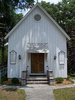
Trinity Episcopal Church, in the district | |
  | |
| Location | Melrose, Florida |
|---|---|
| Coordinates | 29°42′45″N 82°3′3″W / 29.71250°N 82.05083°WCoordinates: 29°42′45″N 82°3′3″W / 29.71250°N 82.05083°W |
| Area | 1250 acres (5.1 km²) |
| NRHP Reference # | 89002305[1] |
| Added to NRHP | January 12, 1990 |
| Wikimedia Commons has media related to Melrose Historic District. |
The Melrose Historic District is a U.S. historic district (designated as such on January 12, 1990) located in Melrose, Florida. It encompasses 1250 acres (5.1 km²), bounded by Seminole Ridge Road, Grove Street, South Street, Quail Street, and Melrose Bay. It contains 65 historic buildings.
See also
References
- ↑ National Park Service (2010-07-09). "National Register Information System". National Register of Historic Places. National Park Service.
External links
- Florida's Office of Cultural and Historical Programs - Alachua County
- Historic Markers in Alachua County

Alachua County architectural survey: Waldo, Archer, Melrose et cetera, 1973: Alachua County survey of historic buildings and architecture - photos, description, history, owners, valuations, condition, general reports especially valuable for original owner information and succeeding owners. In Melrose approximately 42 buildings described - see Melrose pages 26-68 of 94 total pages. University of Florida Dept. or Architecture. . http://ufdc.ufl.edu/UF00103201/00001/1x?search=melrose