Memphis, New York
| Memphis, New York | |
|---|---|
| hamlet | |
 Memphis, New York Location within the state of New York | |
| Coordinates: 43°5′12″N 76°22′40″W / 43.08667°N 76.37778°WCoordinates: 43°5′12″N 76°22′40″W / 43.08667°N 76.37778°W | |
| Country | United States |
| State | New York |
| County | Onondaga |
| Time zone | Eastern (EST) (UTC-5) |
| • Summer (DST) | EDT (UTC-4) |
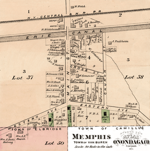
Memphis is a hamlet in the Town of Van Buren, west of Syracuse in Onondaga County, New York, United States.
Because of its location on the south town line of Van Buren, part of Memphis can be considered to be also in the Towns of Elbridge and Camillus. The community was also called, in the past, "Canton," though the name now refers to a small community between Camillus and Memphis.
From 1825 - 1918, The Erie Canal ran through the north side of Memphis. First Baptist Church of Memphis NY was also located in Memphis from 1815 - 2013.
The small community is spread over a wide area due to the primary use of land for farming, including a portion of Hourigan's Farm, the Hooper Farm, and the Bloomer Farms. Some interesting facts about the area include the area known on maps as "The Kingdom," named for Kingdom Road. This area is located west of State Route 31, south of the New York State Thruway, and east of River Road. There is a natural spring, known as Whiskey Hallow, which is located off to the east of Perry Road which the local community uses for a fresh source of water. "The Kingdom" is sometimes known as "Stan's Kingdom," apparently named for a man named Stan, but is often incorrectly known as "Satan's Kingdom."
Municipalities and communities of Onondaga County, New York, United States | ||
|---|---|---|
| City | 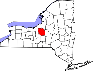 | |
| Towns | ||
| Villages | ||
| CDPs | ||
| Other hamlets |
| |
| Indian reservation | ||
| Footnotes | ‡This populated place also has portions in an adjacent county or counties | |