Manggatal
| Manggatal | |
|---|---|
| Other transcription(s) | |
| • Simplified Chinese | 孟加达 |
| • Traditional Chinese | 孟加達 |
|
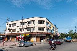
Manggatal town. | |
 Manggatal | |
| Coordinates: 6°01′0″N 116°09′0″E / 6.01667°N 116.15000°E | |
| Country |
|
| State |
|
Manggatal is a Malaysian town and sub-district on the west coast of Sabah. It is an outskirt of the state capital, Kota Kinabalu, and is under the jurisdiction of Kota Kinabalu City Hall. It is located along Jalan Tuaran, which is the main road leading north from Kota Kinabalu city centre.
The town is notable for being one of few towns in Sabah where wooden pre-World War II era shophouses still stand.
Etymology
The name "Manggatal" derives from the Malay words "mangga" (mango) gatal, which means 'itch mango'. Since 2014, there have been proposal to change the name spelling into "Manggatal" which also the original name of the town which before this being called Menggatal.[1] In 2015, the proposal was accepted by the authorities although there were complains from the town residents it was changed without their knowledge or consultation.[2]
Demographics
Manggatal was originally populated sparsely by native Dusuns. In the late 19th and early 20th centuries, this native population was supplemented by Chinese migrants, most of whom were Hakkas. The Chinese community of Manggatal, which is still dominated by Hakkas, plays an important role in the town's economy as its members own most of the shops in the town.
Starting in the 1970s, Manggatal has witnessed a drastic increase in the population of Filipino and Indonesian immigrants, many of whom have been naturalised (both legally and illegally) and live in squatter colonies.
Education
The state's main institution of learning, Universiti Malaysia Sabah, is located in a coastal part of Manggatal sub-district.
References
- ↑ "Support for change of 'Menggatal' to 'Manggatal'". The Borneo Post. 26 February 2014. Retrieved 8 November 2015.
- ↑ "YB: Revert to township's former spelling". Daily Express. 7 November 2015. Retrieved 8 November 2015.
| Districts | |
|---|---|
| Neighbourhoods and Townships |
|
| Towns | |
Capital: Kota Kinabalu | |||||||||||||||||||
| Topics |
| ||||||||||||||||||
| Society |
| ||||||||||||||||||
| Administrative divisions |
| ||||||||||||||||||
| |||||||||||||||||||
Coordinates: 6°01′N 116°09′E / 6.017°N 116.150°E