Metropolitan City of Rome Capital
| Metropolitan City of Rome Capital | ||
|---|---|---|
| Metropolitan City | ||
|
Metropolitan City of Rome Capital | ||
| ||
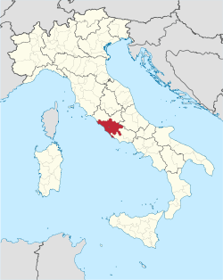 Location of the Metropolitan City of Rome Capital | ||
| Country |
| |
| Region | Lazio | |
| Established | 1 January 2015 | |
| Capital(s) | Rome | |
| Comuni | 121 | |
| Government | ||
| • Mayor | Virginia Raggi (M5S) | |
| Area | ||
| • Total | 5,352 km2 (2,066 sq mi) | |
| Population (2014) | ||
| • Total | 4,333,689 | |
| • Density | 810/km2 (2,100/sq mi) | |
| Time zone | CET (UTC+1) | |
| • Summer (DST) | CEST (UTC+2) | |
| ISTAT | 015 | |
| Website | www.provincia.roma.it | |
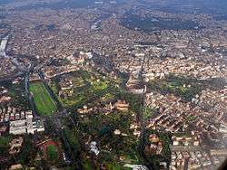
The Metropolitan City of Rome Capital (Italian: Città metropolitana di Roma Capitale) is a metropolitan city in the Lazio region, Italy. Its capital is the city of Rome. It replaced the Province of Rome and comprises the city of Rome and other 121 municipalities (comuni). It was firstly created by the reform of local authorities (Law 142/1990) and then established by the Law 56/2014. It has been officially operative since 1 January 2015.
The Metropolitan City of Rome Capital is headed by the Metropolitan Mayor (Sindaco metropolitano) and by the Metropolitan Council (Consiglio metropolitano). Since 20 june 2016 Virginia Raggi, as mayor of the capital city.
Territory
Geography
The Metropolitan City of Rome Capital covers almost one-third of the territory of Lazio. It occupies the flat area of the Roman and the Tiber Valley to the mountains and dell'Aniene Lucretili Sabini and, in addition to the mountainous regions of the Tolfa and Monti Sabatini to the north-west, the area of the mountains Tiburtini Prenestini Simbruini and east, the area of the Colli Albani and the northern foothills of the mountains, and high Lepine Sacco valley to the south-east. The western boundary of the province is represented by the Tyrrhenian Sea on which spread to about 130 kilometres (81 mi) from the coast near Rome from Civitavecchia to Torre Astura. In the territory there are several lakes, almost all of volcanic origin, which are concentrated in the north-west of the mountains and Sabatini in the south-east of the Colli Albani.
Transport
The Metropolitan City of Rome Capital is at the centre of the radial network of roads that roughly follow the lines of the ancient Roman roads which began at the Capitoline Hill and connected Rome with its empire. Today Rome is circled, at a distance of about 10 km (6 mi) from the Capitol, by the ring-road (the Grande Raccordo Anulare or GRA).
Due to its location in the centre of the Italian peninsula, Rome is the principal railway node for central Italy. Rome's main railway station, Termini, is one of the largest railway stations in Europe and the most heavily used in Italy, with around 400 thousand travellers passing through every day. The second-largest station in the city, Roma Tiburtina, has been redeveloped as a high-speed rail terminus.[1]
Rome is served by three airports. The intercontinental Leonardo da Vinci International Airport is Italy's chief airport, is located within the nearby Fiumicino, south-west of Rome. The older Rome Ciampino Airport is a joint civilian and military airport. It is commonly referred to as "Ciampino Airport", as it is located beside Ciampino, south-east of Rome. A third airport, the Roma-Urbe Airport, is a small, low-traffic airport located about 6 km (4 mi) north of the city centre, which handles most helicopter and private flights.
Although the city has its own quarter on the Mediterranean Sea (Lido di Ostia), this has only a marina and a small channel-harbour for fisher boats. The main harbour which serves Rome is Port of Civitavecchia, located about 62 km northwest of the city.[2]
A 3-line metro system called the Metropolitana operates in the Metropolitan City of Rome. Construction on the first branch started in the 1930s. The line had been planned to quickly connect the main railway station with the newly planned E42 area in the southern suburbs, where the 1942 World Fair was supposed to be held. The event never took place because of war, but the area was later partly redesigned and renamed EUR (Esposizione Universale di Roma: Rome Universal Exhibition) in the 1950s to serve as a modern business district. The line was finally opened in 1955, and it is now the south part of the B Line.
The A line opened in 1980 from Ottaviano to Anagnina stations, later extended in stages (1999–2000) to Battistini. In the 1990s, an extension of the B line was opened from Termini to Rebibbia. This underground network is generally reliable (although it may become very congested at peak times and during events, especially the A line) as it is relatively short.
The A and B lines intersect at Roma Termini station. A new branch of the B line (B1) opened on 13 June 2012 after an estimated building cost of €500 million. B1 connects to line B at Piazza Bologna and has four stations over a distance of 3.9 km (2 mi).
A third line, the C line, is under construction with an estimated cost of €3 billion and will have 30 stations over a distance of 25.5 km (16 mi). It will partly replace the existing Termini-Pantano rail line. It will feature full automated, driverless trains.[3] The first section with 15 stations connecting Pantano with the quarter of Centocelle in the eastern part of the city, opened on 9 November 2014.[4] The end of the work was scheduled in 2015, but archaeological findings often delay underground construction work.
A fourth line, D line, is also planned. It will have 22 stations over a distance of 20 km (12 mi). The first section was projected to open in 2015 and the final sections before 2035, but due to the city's financial crisis the project has been put on hold.
Largest municipalities

| Comune | Population |
|---|---|
| Rome | 2,866,733 |
| Guidonia Montecelio | 88,238 |
| Fiumicino | 75,378 |
| Pomezia | 61,207 |
| Tivoli | 56,568 |
| Anzio | 53,760 |
| Velletri | 52,998 |
| Civitavecchia | 52,942 |
| Ardea | 48,495 |
| Nettuno | 48,346 |
Metropolitan Council
The new Metro municipalities, giving large urban areas the administrative powers of a province, are conceived for improving the performance of local administrations and to slash local spending by better coordinating the municipalities in providing basic services (including transport, school and social programs) and environment protection.[5] In this policy framework, the Mayor of Rome is designated to exercise the functions of Metropolitan mayor, presieding over a Metropolitan Council formed by 24 mayors of municipalities within the Metro municipality.
The first Metropolitan Council of the City was elected on 5 October 2014:
| Group | Seats | |
|---|---|---|
| PD | 14 / 24 | |
| FI | 4 / 24 | |
| M5S | 2 / 24 | |
| NCD | 2 / 24 | |
| Others | 2 / 24 | |
References
- ↑ – Entry on Roma Tiburtina station on the official website of the Italian high-speed rail service (Italian)
- ↑ "Porti di Roma". Retrieved 6 March 2015.
- ↑ Kington, Tom (14 May 2007). "Roman remains threaten metro". Guardian. London. Retrieved 10 August 2008.
- ↑ "Metro C, apre la Pantano-Centocelle: folla di romani all'inaugurazione". Il Messaggero (in Italian). 9 November 2014. Retrieved 11 November 2014.
- ↑ Vittorio Ferri (2009). "Metropolitan cities in Italy. An institution of federalism" (PDF). University of Milan-Bicocca. Retrieved 23 May 2011.
| Metropolitan cities | |
|---|---|
| Metropolitan areas | |
| Provinces |  | |
|---|---|---|
| Lakes | ||
| Mountains |
| |
| Geography | ||
| Politics | ||
Categories | ||
Coordinates: 41°53′35″N 12°28′58″E / 41.89306°N 12.48278°E