Midway Point, Tasmania
| Midway Point Hobart, Tasmania | |||||||||||||
|---|---|---|---|---|---|---|---|---|---|---|---|---|---|
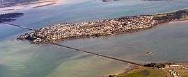 Aerial view with causeway | |||||||||||||
| Coordinates | 42°48′12″S 147°31′57″E / 42.80333°S 147.53250°ECoordinates: 42°48′12″S 147°31′57″E / 42.80333°S 147.53250°E | ||||||||||||
| Postcode(s) | 7171 | ||||||||||||
| LGA(s) | Sorell Council | ||||||||||||
| |||||||||||||
Midway Point is an outlying suburb of Hobart, capital of Tasmania, Australia. It is in the local government area of Sorell Council, and is located on a small peninsula with Orielton Lagoon on its eastern side and Pittwater (Tasmania) on its southern and western sides. The suburb meets the mid-way point of the Sorell Causeway from Hobart to Sorell, hence the name. The suburb lies close to Hobart International Airport and is approximately 21 km to Hobart via the Tasman Highway. In recent years Midway Point has become a popular commuter town for people working in Hobart.
References
Sources
This article is issued from Wikipedia - version of the 11/9/2016. The text is available under the Creative Commons Attribution/Share Alike but additional terms may apply for the media files.