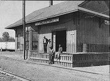
Mileston, Mississippi
| Mileston, Mississippi | |
|---|---|
| Unincorporated community | |
 Mileston, Mississippi  Mileston, Mississippi | |
| Coordinates: 33°06′37″N 90°16′24″W / 33.11028°N 90.27333°WCoordinates: 33°06′37″N 90°16′24″W / 33.11028°N 90.27333°W | |
| Country | United States |
| State | Mississippi |
| County | Holmes |
| Elevation | 112 ft (34 m) |
| Time zone | Central (CST) (UTC-6) |
| • Summer (DST) | CDT (UTC-5) |
| ZIP code | 39169 |
| Area code(s) | 662 |
| GNIS feature ID | [1] |
Mileston is an unincorporated community located in Holmes County, Mississippi. Mileston is located on U.S. Highway 49E approximately 6 miles (9.7 km) south of Tchula, approximately 4 miles (6.4 km) north of Thornton and approximately 3 miles (4.8 km) southeast of Marcella.
References

Municipalities and communities of Holmes County, Mississippi, United States | ||
|---|---|---|
| Cities | 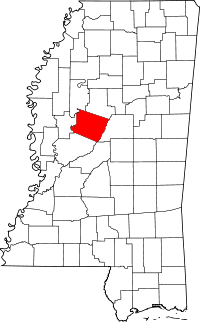 | |
| Towns | ||
| Unincorporated communities | ||
This article is issued from Wikipedia - version of the 7/30/2016. The text is available under the Creative Commons Attribution/Share Alike but additional terms may apply for the media files.