Mill Rock
 Mill Rock as seen from Wards Island Bridge. The Citicorp Building and Big Allis are visible in the background. | |
 Mill Rock | |
| Geography | |
|---|---|
| Location | East River/Harlem River, New York County, New York, USA |
| Coordinates | 40°46′51″N 73°56′18″W / 40.7807°N 73.9384°WCoordinates: 40°46′51″N 73°56′18″W / 40.7807°N 73.9384°W |
| Area | 0.01617 km2 (0.00624 sq mi) |
| Administration | |
|
United States | |
| State | New York |
| City | New York City |
| Borough | Manhattan |
Mill Rock is a small unpopulated island between Manhattan and Queens in New York City, in the state of New York. It lies about 1,000 feet (300 m) off Manhattan's East 96th Street,[2] south of Randalls and Wards Islands, where the East River and Harlem River converge. The island forms Census Block 9000 of Census Tract 238 in New York County. (Except for Mill Rock Island, Census Tract 238 consists entirely of Roosevelt Island.) Its official area is 16,173 square meters, or 3.996 acres (16,170 m2).
This area was infamous as a treacherous area for shipping vessels to pass, and was known as the Hell Gate.
History
Originally two smaller islands, in 1664, William Hallet bought them from the local tribes. In 1701, John Marsh built a mill on one of them and the islands came to be called Great Mill Rock and Little Mill Rock.[2] The island was later squatted on by Sandy Gibson, who operated a farm on the island.
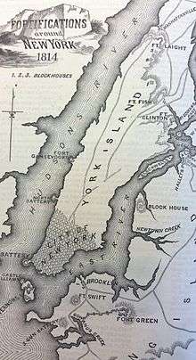
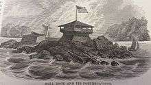
During the War of 1812, the War Department built a blockhouse with two cannons on Great Mill Rock. This fortification was part of a chain of blockhouses that was intended to defend New York Harbor and protect the passage into Long Island Sound from the British Navy.[2]
In 1885, the United States Army Corps of Engineers detonated 300,000 lb (136,000 kg) of explosives on adjoining Flood Rock; that island had been the most treacherous impediment to East River shipping. It was, most likely, the most forceful explosion in New York City's history at the time; it was felt as far away as Princeton, New Jersey.[3][4] The explosion has been described as "the largest planned explosion before testing began for the atomic bomb",[5] although the detonation at the Battle of Messines (1917) was larger. In 1890 the Flood Island remnants were used to fill the space between Great and Little Mill Rocks, producing Mill Rock.[3]
Mill Rock Park
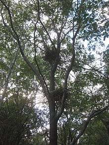
Mill Rock Park is a 3-acre (12,000 m2) park on the island. Owned by the City of New York and maintained by the New York City Department of Parks and Recreation, the park is populated by a few short trees. There is a dock on the southern shore of the island but it has not been opened to the public since the 1960s when there were public events, and it has since been allowed to return to its state of shrubbery. Because of its locale between Queens and Manhattan the island is a great spot for views of the towering skyscrapers of Midtown Manhattan. The island also provides views of the Triborough Bridge and the Queensboro Bridge. Since roughly 2008 the island has been home to a nesting colony of black-crowned night herons, great egrets, snowy egrets, great black-backed gulls, fish crows, and double-crested cormorants. The herons and egrets are thought to have relocated to Mill Rock from nearby North Brother Island. There are no plans for the island.
References
- 1 2 Lossing, Benson (1868). The Pictorial Field-Book of the War of 1812. Harper & Brothers, Publishers. p. 972.
- 1 2 3 "Mill Rock Park", New York City Department of Parks & Recreation
- 1 2 "Mill Rock Island - Historical Sign". nycgovparks.org. Retrieved 2009-04-12.
- ↑ Buchanan, Brenda J (2006). Gunpowder, explosives and the state: a technological history. p. 367. ISBN 978-0-7546-5259-5.
- ↑ Whitt, Toni (June 2, 2006). "The East River is Cleaner Now. The Water Birds Say So.". The New York Times. Retrieved 2009-04-12.
| Major islands |  | |
|---|---|---|
| Pelham Islands | ||
| New York Bay | ||
| Jamaica Bay | ||
| Arthur Kill · Kill Van Kull | ||
| East River | ||
Former islands shown in italics | ||
| |||||||||||||||||||||||||
| |||||||||||||||||||||||||
| |||||||||||||||||||||||||
| |||||||||||||||||||||||||