Missouri Route 364
| ||||
|---|---|---|---|---|
| Page Avenue Freeway | ||||
| Route information | ||||
| Maintained by MoDOT | ||||
| Length: | 21.384 mi[1] (34.414 km) | |||
| Existed: | 2003 – present | |||
| Major junctions | ||||
| West end: |
| |||
|
| ||||
| East end: |
| |||
| Highway system | ||||
| ||||

Route 364, known locally as the Page Avenue Extension , the Page Avenue Freeway, or simply the Page Expressway, is a freeway that connects St. Louis County in Maryland Heights with St. Charles County in Lake St. Louis via the Veterans Memorial Bridge over the Missouri River. The highway is a designated auxiliary state route of I-64.
Route description
The current termini are at an interchange with I-270 to the east and at the intersection of I-64/US-40/US-61 to the west. The west end of the freeway was marked at Route 94 and Mid Rivers Mall Drive/Pitman Hill Rd. until November 2, 2014, when the Phase III expansion was opened.
The opening of the freeway increased the number of lanes across the Missouri River in the St. Louis metropolitan area from 23 to 33. It provides an alternate route to the Daniel Boone Bridge, Blanchette Memorial Bridge, and Discovery Bridge crossings.
History

The East-West Gateway Council of Governments determined there was a need for the freeway in 1969. However, little progress was made until the commissioning of the Page Avenue Bridge Committee in the fall of 1984. An earlier alignment, called the Green Line, bypassed Creve Coeur Lake Memorial Park and took the freeway to I-70, but it could no longer be considered due to the rapid growth of the city of St. Peters and because the park expanded in size and encroached on the proposed alignment anyway. The committee proposed a new alignment called the Red Line and the Missouri Department of Transportation (MoDOT) authorized the project in the fall of 1986. The next spring, Missouri voters approved a fuel tax increase which included funding for the project. MoDOT held numerous meetings since then, but the alignment was not approved until June 1990. The United States Congress passed legislation in October 1992 authorizing the project as part of the Pipeline Safety Act of 1992.[2] The environmental impact study was completed in November 1992, but, just before the project was to receive final clearance from the federal government, Secretary of the Interior Bruce Babbitt took office and ordered more environmental studies resulting in more land mitigation for intrusion into Creve Coeur Lake Memorial Park. In the fall of 1995, the federal government gave the final clearance for the project 11 years after active planning began. For nearly 27 years, the roadway was simply referred to as the Page Avenue Extension, but in February 1996 MoDOT gave the freeway an official designation of MO-364. Construction on the freeway is divided into 3 separate phases and began with the first project in 1997.[3][4]
Phase I
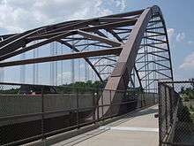
Phase I included work from I-270 to Route 94 through the Creve Coeur Lake Memorial Park, but due to concerns with traffic congestion at the proposed terminus with MO-94 it was decided to extend the freeway further west along its concurrency with MO-94 to Harvester Rd. Two major bridge structures were required, which included the Veterans Memorial Bridge and Creve Coeur Lake Memorial Park Bridge which cost $79 million and $74 million respectively. Both structures are designed to withstand seismic activity from the nearby New Madrid Fault. The total cost to construct this phase was approximately $350 million.[5]
This phase also included improvements to the Creve Coeur Lake Memorial Park. The park nearly doubled in size and an existing bike trail there was linked to the Katy Trail in St. Charles County via the Veterans Memorial Bridge. The Creve Coeur Lake was dredged and a siltation lake was added to eliminate the need for future dredging.
A ribbon cutting ceremony occurred on December 13, 2003. The ceremony was held on the eastbound lanes of the Veterans Memorial Bridge. Dignitaries that spoke included then Governor Bob Holden and Senator Christopher "Kit" Bond. Following the various speeches and ribbon cutting, a ceremonial first drive occurred between Upper Bottom Rd/Arena Parkway and Maryland Heights Expressway. Due to inclement weather, MoDOT opted to use December 13, 2003 to clear snow off the freeway and delayed opening the freeway until around 10:00 am on December 14, 2003 after the roadway was cleared.
The section of the freeway in St. Louis County has been dedicated the Buzz Westfall Memorial Freeway after former St. Louis County Executive Buzz Westfall who helped get the freeway built. Westfall died in 2003, months before the freeway opened.
A new interchange taking NB I-270 to WB MO-364 opened to traffic on July 22, 2011. This two lane ramp replaced a cumbersome cloverleaf movement which caused frequent backups on I-270.
Phase II
Phase II work extended the freeway along its concurrency with Route 94 to Route N/Mid Rivers Mall Dr including a one way outer road system. Work along MO-94 from Portwest Dr to Harvester Rd was completed as part of the Phase I. This phase of construction was completed on August 30, 2012.
Completion of Phase II had originally been proposed to happen in segments with each interchange constituting a separate project. Work began on the Harvester Road interchange with grading and utility relocation in the fall of 2006.[6][7] In 2008, the Jungermann Road and Woodstone Drive interchanges had been approved, funded, and scheduled for construction in 2010. However, the American Recovery and Reinvestment Act of 2009 accelerated that project and included funding for the segment to construct the Central School Road interchange. The final Phase II projects including grade separated interchanges at Kisker Rd and Mid Rivers Mall Drive were approved and funded shortly thereafter.[8][9]
The Harvester Road interchange opened to traffic on July 27, 2010. Phase II to Mid Rivers Mall Drive opened on August 30, 2012.[10][11]
Phase III
MoDOT, St. Charles County and local municipalities teamed together to allocate $118.2 million towards building Route 364/Page Phase 3. The $118.2 million was used for purchasing property, utility relocations, design and construction. The project included building an improved connection from Page Phase 2 at Route 94 and Mid Rivers Mall Drive to I-64/US Route 40/61 at Route N. MoDOT used a Design-Build contracting process to have contractor teams compete to win the contract. The Missouri Highways and Transportation Commission approved the contract on February 6, 2013, awarding the project to the Page Constructors Joint Venture, which includes Fred Weber Inc. and Millstone-Bangert Inc (now known as Millstone Weber) along with Kolb Grading and lead designer, Parsons Transportation Group.
Phase III extended the freeway from Mid Rivers Mall Drive/Pitman Hill Road to I-64/US-40/US-61 paralleling, but not overtaking, the existing Route N. The interchange at I-64 and Route N, which opened in October, 2005, became the western terminus of the freeway upon its completion. Final approval and funding was granted in August, 2011. Construction was underway from the spring of 2013 until the fall of 2014. Phase III was opened up in stages from Route 94 to I-64.[12] A segment of the highway from I-64 to Route K was opened on October 4, 2014, and the segment from Route K to Route 94/Mid Rivers Mall Drive opened on the evening of November 2, 2014.[13]
Several streets near Mid Rivers Mall Drive were rerouted due to the change. Cimarron Drive, near Cottleville, was split in half by the new freeway, and the new entrance to the north section of the street was added off of Motherhead Road. Also, the Columbus Pointe subdivision in Cottleville was cut in half due to a small portion of Gutermuth Road being torn down. Norgate Court is now only accessible by the west side of Gutermuth Road, and Wavecrest Way is accessible by the east end of Gutermuth Road. The two streets in the same subdivision are now almost a mile apart. Several of these changes have been confusing to visitors of the area.
Controversy
Controversy over the construction of the freeway came from several sources. The freeway's alignment would take it through the Creve Coeur Lake Memorial Park and the floodplain of the Missouri River drawing opposition from environmental groups including the Sierra Club[14] and the Missouri Coalition for the Environment.[15] Its high cost and debate over urban sprawl forced many St. Louis County municipalities to pass resolutions opposing the freeway.[16] A petition to put the freeway up for referendum was submitted in 1998, and enough signatures were collected to force a vote. On November 3, 1998, voters approved right-of-way for the freeway by a 61% margin, and construction continued.[17] In exchange, St. Louis County accepted 1,005 acres (4.07 km2) of land adjacent to the park.[18]
Exit list
| County | Location | mi[1] | km | Exit | Destinations | Notes |
|---|---|---|---|---|---|---|
| St. Charles | Lake St. Louis | 0.000 | 0.000 | – | Continuation beyond I-64 / US 40 / US 61, exit 4A. | |
| 0.330 | 0.531 | 1 | Western terminus; I-64 exit 4B; signed as exits 1A (west) & 1B (east). | |||
| 0.701 | 1.128 | Henke Road | Signed as exit 1C; westbound exit and eastbound entrance | |||
| O'Fallon | 2.227 | 3.584 | 2 | Bryan Road | ||
| 4.717 | 7.591 | 4 | ||||
| St. Peters | 8.748 | 14.079 | 8A | Western terminus of Route 94 concurrency | ||
| 8.931 | 14.373 | 8B | Mid Rivers Mall Drive / Pitman Hill Road (Route N) | |||
| 9.787– 10.322 | 15.751– 16.612 | 9A | Central School Road / Harvestown Industrial Drive | Signed as Exit 9 westbound | ||
| 11.333 | 18.239 | 10 | Jungermann Road | Eastbound exit and westbound entrance | ||
| 11.737– 12.076 | 18.889– 19.434 | 11 | Woodstone Drive / Harvester Road | Signed as exits 11A (Woodstone) and Exit 11B (Harvester) | ||
| St. Charles | 13.428 | 21.610 | 13 | Eastern terminus of Route 94 concurrency | ||
| | 14.977 | 24.103 | 14 | Arena Parkway / Upper Bottom Road | ||
| Missouri River | 15.643 | 25.175 | Veterans Memorial Bridge | |||
| St. Louis | Maryland Heights | 17.932 | 28.859 | 17 | ||
| 20.329 | 32.716 | 19 | Bennington Place | |||
| 21.111 | 33.975 | 20 | Eastern terminus; I-270 north exit 16, south exit 16B; signed as exits 20A (south) & 20B (north). | |||
| 21.384 | 34.414 | – | Continuation beyond I-270, north exit 16, south exit 16A. | |||
1.000 mi = 1.609 km; 1.000 km = 0.621 mi
| ||||||
See also
-
 Missouri portal
 -
 U.S. Roads portal
References
- 1 2 Missouri Department of Transportation (March 20, 2015). Flex Map Viewer (Map). Missouri Department of Transportation. Retrieved March 20, 2015.
- ↑ "Pipeline Safety Act of 1992". United States Congress. October 1992. Retrieved 2006-12-29.
- ↑ "Chronology of the Page Avenue Extension" (PDF). Missouri Department of Transportation. October 2003. Retrieved 2006-10-14.
- ↑ "St. Charles County Focus (Winter 2003)" (PDF). St. Charles County Government. 2003. Retrieved 2006-11-11.
- ↑ "Twin Bridges on Road Extension Turn a New Page Near St. Louis" (Press release). Edward Kraemer & Sons, Inc. 2001-01-19. Retrieved 2006-10-14.
- ↑ "Harvester Rd Construction Overview" (PDF). Missouri Department of Transportation. August 2007. Retrieved 2007-09-22.
- ↑ "Workers begin extending Highway 364". St. Louis Post-Dispatch. 2007-08-25.
- ↑ "Page Avenue Updates". Missouri Department of Transportation. Retrieved 2010-09-12.
- ↑ "Page Avenue work approved". St. Louis Post-Dispatch. 2008-07-30.
- ↑ "Page extension phase 2 to open 2 months early in St. Charles County". St. Louis Post-Dispatch. 2012-07-26. Retrieved 2012-07-29.
- ↑ "MoDOT: Page Avenue Extension phase 2 completed ahead of schedule". KMOV. 2012-07-26. Retrieved 2012-07-29.
- ↑ "Commission approves funds to complete Page extension". St. Louis Post-Dispatch. 2011-08-03.
- ↑ "Route 364/Page Phase 3 Project Alerts & Updates". MoDOT. Retrieved 10 November 2014.
- ↑ "1998 Sierra Club Sprawl Report". Sierra Club. Retrieved 2006-10-14.
- ↑ "Road to Ruin: Page Avenue Extension". Archived from the original on October 12, 2006. Retrieved 2006-10-14.
- ↑ "Progress on Stopping the Page Avenue Freeway". Retrieved 2006-10-14.
- ↑ "Page Avenue Extension is Approved By Wide Margin". St. Louis Post-Dispatch. 1998-11-04. pp. B1.
- ↑ "Page Avenue extension is continuing on schedule" (Press release). Edward Kraemer & Sons, Inc. 2001-11-14. Retrieved 2006-10-14.
External links
-
 Media related to Missouri Route 364 at Wikimedia Commons
 - Page Avenue Updates (Missouri Department of Transportation)