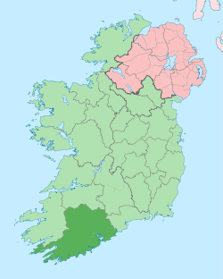
Mizen Head
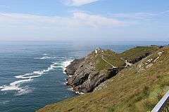
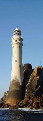
Mizen Head (Irish: Carn Uí Néid), is located at the extremity of the Kilmore Peninsula in the district of Carbery in County Cork, Ireland. It is one of the extreme points of the island of Ireland and is a major tourist attraction, noted for its dramatic cliff scenery. One of the main transatlantic shipping routes passes close by to the south, and Mizen Head was, for many seafarers, the first (or last) sight of Europe. The tip of the peninsula is almost an island, cut off by a deep chasm, now spanned by a bridge; this gives access to an old signal station, a weather station, and a lighthouse. The signal station, once permanently manned, is now a museum housing displays relating to the site's strategic significance for transatlantic shipping and communications, including the pioneering efforts of Guglielmo Marconi. The "99 steps" which formed part of the original access route have been supplemented by a series of paths and viewing platforms, and a full range of visitor facilities is available at the entrance to the site. The villages of Ballydehob, Crookhaven, Goleen, and Schull are located on the peninsula to the east.
Mizen Head is not the most southerly point on the mainland of Ireland; nearby Brow Head holds that title. Nevertheless, geography books have long measured the length of Ireland "from Fair Head to Mizen Head"[1] or "from Malin Head to Mizen Head.[2]
See also
References
Sources
- Mizen Journal, Archaeology Paddy O'Leary, No 11, 2003 ISSN 1649-203X
- Archaeological Inventory of County Cork, Vol 1 West Cork, Office of Public Works, 1992 ISBN 0-7076-0175-4
- BHAS Journal vol 2 p.106-119, Townlands Donal Fitzgerald ISSN 0791-6612
- Northside of the Mizen, General reading, Patrick McCarthy & Richard Hawkes
External links
Coordinates: 51°27′1″N 9°49′10″W / 51.45028°N 9.81944°W
Irish lighthouses | ||
|---|---|---|
Lighthouses are shown in anti-clockwise sequence beginning from the north and proceeding west, south, east, and back to north. | ||
| County Donegal |
|  |
| County Sligo |
| |
| County Mayo |
| |
| County Galway |
| |
| County Clare |
| |
| County Kerry |
| |
| County Cork |
| |
| County Waterford |
| |
| County Wexford | ||
| County Wicklow | ||
| County Dublin |
| |
| County Louth | ||
| County Down |
| |
| County Antrim |
| |