Mochrum
Coordinates: 54°48′N 4°34′W / 54.80°N 4.56°W
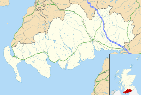
Mochrum (/ˈmɔːxrʌm/; Scottish Gaelic: Magh-dhruim, ‘ridge of the plain’) is a coastal civil and Church of Scotland parish situated to the east of Luce Bay on the Machars peninsula and 8 miles (13 km) southwest of Wigtown in Galloway, Scotland. It covers 22,000 acres (8,900 ha) and is approximately 10 miles (16 km) in length and 5 miles (8.0 km) in breadth. The parish contains the eponymous village of Mochrum, as well as Port William and the clachan of Elrig.
Kirk of Mochrum
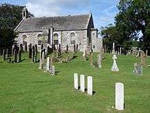
Mochrum kirk was built on the site of a previous church building dating back to the 12th century. The former building was largely destroyed by fire in the 1770s, and the current building used most of the former building's rectangular walls in its construction in 1794, and was substantially altered again ca. 1840.
The churchyard contains ten war graves, of which four male and one female are unknown.
History
Sir John Dunbar of Mochrum was killed at the Battle of Flodden in 1513. He was survived by his wife Janet Stewart, and his third son Gavin Dunbar (1490-1547), became Archbishop of Glasgow in 1524. A fortified mediaeval manor house is located at Castle Island, also called Drumwalt.
Myretoun McCulloch was owned by the McCullochs, and in 1574 they had the 5-merkland of Balsalloch in the "Barony of Myretoun".[1] Myretoun Castle is on the Monreith Estate, on the border of Mochrum and Glasserton parishes. It was owned by Sir William Maxwell, and then the Maxwells built Monreith House. Myrtoun Castle was built on an earlier motte,[2] but was there also a castle and motte on the island.
Archaeology
Mochrum is the site of numerous prehistoric forts, earthworks, standing stones, and crannógs
About 1 mile (1.6 km) from Monreith is Barsalloch Point, where evidence of human encampments as early as 6000 BC may make it the oldest dated settlement in Galloway.
Barsalloch Iron Age fort at Mochrum, as well as both early and medieval crosses.[3][4] There is another Iron Age hill fort at Doon of May hill fort.[5]
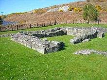
The foundations are all that is left of Chapel Finian, a 10th-11th-century chapel standing on an old raised beach at Corwall Port. It most likely takes its name from Saint Finnian who was educated at nearby Whithorn and died ca. 579 AD. The site was probably a landing place for Irish pilgrims to Saint Ninian's shrine.[6] It is shown on Timothy Pont's map in Blaeu's Atlas, as "Chappel finan".[7]
Druchtag Motehill is a steep-sided mound and site of a 12th-century motte-and-bailey castle, lying about 100 metres (330 ft) north west of Mote Brae.[8][9][10] The Old Place of Mochrum was built in 1368.[11]
A crannog is in Elrig Loch.[12] A standing stone, the Carlin Stone, can be found on The Derry, near to the head of Elrig Loch. The ruins of a mediaeval chapel can be found at Barhobble, which is near to the House of Elrig.[13]
See also
Gallery
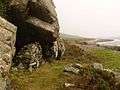 Garheugh Cave
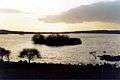 Castle Island, Castle Loch
 Castle Loch burn flows from Castle Loch into Mochrum Loch
 Bronze Age cairn on Mochrum Fell
 Burial cist on Mochrum Fell
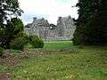 Old Place of Mochrum, Drumwalt
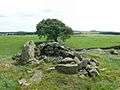 Mote of Crailloch and site of chapel on the right
.jpg) View from the base of Mote of Crailloch
View from the base of Mote of Crailloch view of Mochrum Fell
 Iron Age Hill Fort, Doon of May
 Mote of Druchtag
 Steps to Barsalloch Fort Iron-Age Settlement
 Elrig Loch crannog on the right
References
- ↑ Rodney L. McCulloh. "Myreton 1". Mccullohreunion.org. Retrieved 2014-06-18.
- ↑ "Myrton Castle". ScotlandsPlaces. Retrieved 2014-06-18.
- ↑ "Barsalloch Fort Property Detail". Historic Scotland. Retrieved 2014-06-18.
- ↑ The Megalithic Portal and Megalith Map (2007-10-28). ": The Megalithic Portal and Megalith Map:". 46.37.163.74. Retrieved 2014-06-18.
- ↑ "Site Record for Doon Of May, May Details Details". Canmore.rcahms.gov.uk. Retrieved 2014-06-18.
- ↑ "finian". Dumfriesmuseum.demon.co.uk. Retrieved 2014-06-18.
- ↑ National Library of Scotland http://maps.nls.uk/atlas/blaeu/page.cfm?id=95
- ↑ Rodney L. McCulloh. "Druchtag Motte - 1". Mccullohreunion.org. Retrieved 2014-06-18.
- ↑ "Druchtag Motte Property Detail". Historic Scotland. Retrieved 2014-06-18.
- ↑ "Druchtag Mote Hill". ScotlandsPlaces. Retrieved 2014-06-18.
- ↑ Archived March 9, 2012, at the Wayback Machine.
- ↑ "Loch Elrig Crannog". megalithic.co.uk.
- ↑ "Local St. Ninian Sites including St. Ninian's Cave, St. Ninian's Chapel and the Witness Cairn". Whithorn.com. Retrieved 2014-06-18.
| Wikimedia Commons has media related to Mochrum. |