Portpatrick
| Portpatrick | |
| Scottish Gaelic: Port Phàdraig | |
| Scots: Portpaitrick[1] | |
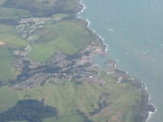 Aerial view of Portpatrick. |
|
 Portpatrick |
|
| Population | 960 (2001) |
|---|---|
| OS grid reference | NW995545 |
| Civil parish | Portpatrick |
| Council area | Dumfries and Galloway |
| Lieutenancy area | Wigtownshire |
| Country | Scotland |
| Sovereign state | United Kingdom |
| Post town | Stranraer |
| Postcode district | DG9 |
| Dialling code | 01776 |
| Police | Scottish |
| Fire | Scottish |
| Ambulance | Scottish |
| EU Parliament | Scotland |
| UK Parliament | Dumfries and Galloway |
| Scottish Parliament | Galloway and West Dumfries |
Coordinates: 54°50′42″N 5°07′27″W / 54.84504°N 5.12429°W
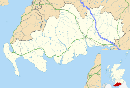
Portpatrick (Scottish Gaelic: Port Phàdraig), is a village and civil parish in Dumfries and Galloway, south-west Scotland. It is located on the west coast of the Rhins of Galloway, in the traditional county of Wigtownshire. The parish is about 4 1⁄2 miles (7 km) in length and 4 miles (6 km) in breadth, covering 9,300 acres (3,800 ha).[2][3]
History
Portpatrick village is on the south-westerly coast of the Scottish mainland, cut into a cleft in steep cliffs. Anciently known as Portrie (Port Rhin), its quay was protected by the baron of Dunskey Castle (from dun meaning castle; key meaning quay) and his local men. When being invaded, the fishermen and their families probably scrambled up the cliffs to Dunskey for protection.
Dating back some 700 years and built adjacent to the ruins of nearby Dunskey Castle, Portpatrick's position on the Rhins of Galloway affords visitors views of the Northern Irish coast 21 miles (34 km) to the west, with cliff-top walks and beaches both north and south. The Gulf Stream, flowing in from the north, gives the coastline a pleasant climate, in which subtropical plant life can flourish.
Portpatrick has a Community Council,[4] and an annual Life Boat Week, featuring parades, activities, and a firework display.[5] There are bowls clubs, a golf club, many guesthouses and hotels, and rustic public houses. The village is also home to a mini putting course.
To the north of the village is the starting point of the Southern Upland Way, a long-distance walking route to Cockburnspath on the east coast. The Portpatrick Hotel, built in 1905 and extended in 1907, sits on the cliffs above this point.
The village was used as one of the locations for the 1952 film Hunted.
Features
Harbour
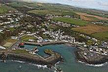
Portpatrick village was founded on fishing, operating from the sandy, crescent-shaped harbour that remains the focal point of the village today. Attempts were made to render it safer from the strong North Channel gales. In 1770 John Smeaton, the leading civil engineer of his day, was appointed to make further improvements. He constructed breakwaters that turned the sandy bay into an enclosed harbour. Strong westerly winds and waves eventually broke through this construction, and in 1821 John Rennie was appointed to create a new harbour defined by two new piers. Money and weather problems meant that these piers were never finished. The calm inner basin, now home to the port's lifeboat, was constructed between 1861 and 1863, too late to prevent the government switching the mail service to boats that plied between Stranraer and Larne. The harbour retains a fleet of fishing craft, a Navtex and a lifeboat station.[6]
St Patrick's Church
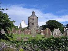
This ruined church, dating from 1629, may itself stand on the ruins of an earlier church, known as St Patrick's Chapel. The circular tower may date from the 1520s, and originally stood on its own. Its unusual shape (for Scotland) may mean that it was either a lighthouse for the harbour, or heavily influenced by Irish architecture.
In the 18th and 19th centuries, when Portpatrick was an important ferry port for passengers, postal mail and freight between Ireland and Scotland, the village was described as the Gretna Green for Ireland. There was a daily packet boat from Donaghadee, and marriages for couples from Ireland were conducted by the Church of Scotland minister in Portpatrick, although according to Brack (1997) he often overlooked the rules about the publication of banns or the required period of residence. It's believed that happy couples could disembark, complete the ceremony, and be back on board within an hour.
The graveyard around the church contains memorials to many victims of shipwrecks in nearby waters. Joined to the original chapel was a district by the name of the Black Quarter of Inch. When the church was rebuilt in 1629, the Black Quarter was disjoined from Inch and erected as the Parish of Montgomorie. The name of the parish however was changed after only two or three years to that of Portpatrick.
Railway
Portpatrick railway station, completed in 1861, was the original terminus of the Portpatrick Railway. In its hey-day, it received twelve-coach trains excursions from Glasgow. It ran its last service, to Stranraer, on 6 February 1950.
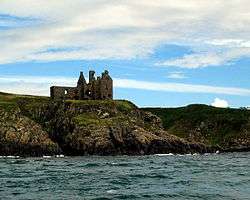
Dunskey Castle
1⁄2 mile (800 m) south of the village is Dunskey Castle, reached via a steep trail incorporating steps and a narrow bridge. The site has seen at least two castles, though the present ruins date from the 16th century.[7]
Cairn Pat (Cairnpot) Hill Fort or settlement
_Hill_Fort.jpg)
A large fort or walled settlement enclosed an area of 1.2 hectares (3.0 acres), about 137 by 125 metres (449 ft × 410 ft), within two walls, covered on the west by two ramparts set about 5.5 metres (18 ft) and 9.5 metres (31 ft) apart, with external ditches. A third rampart 2.1 metres (6 ft 11 in) thick by 0.3 metres (1 ft 0 in) high was on the southern approach, outside of which was a low bank about 1.5 metres (4 ft 11 in) wide. On the west-north-west arc of the second wall there was an entrance gap about 1.2 metres (3 ft 11 in) wide. On the north a 2.1-metre (6 ft 11 in) road passed diagonally through the defences from the north-west. From the south-east a natural hollow ran out from the fort, flanked on the west by a face of outcropping rock. At the head of it on the west side within the inner rampart were foundations of a small circular structure measuring internally about 2.1 metres (6 ft 11 in) and overall 3.7 metres (12 ft).[8]
Portpatrick NAVTEX transmissions
Portpatrick is the base from which Navtex transmissions for the seas North and West of the UK are broadcast.[9] For the purpose of extended Shipping forecasts, the Met Office uses Portpatrick as the name of the forecast area covering the sea between South-East Iceland and Lundy, including the waters around Ireland[10]
See also
References
- ↑ Andy Eagle (2003-02-27). "The Online Scots Dictionary". Scots-online.org. Retrieved 2014-03-23.
- ↑ "View: A map of the county of Wigton. - Counties of Scotland, 1580-1928 - National Library of Scotland". Maps.nls.uk. Retrieved 2014-03-23.
- ↑ "Portpatrick Map". Scottish-places.info. Retrieved 2014-03-23.
- ↑ "Portpatrick Community Council Home". Portpatrick-communitycouncil.org.uk. Retrieved 2014-03-23.
- ↑ "Portpatrick Lifeboat week 2012". Portpatrick Holiday Cottage. 2012-06-24. Retrieved 2014-03-23.
- ↑ "Portpatrick lifeboat station". Geolocation.ws. 2012-04-25. Retrieved 2014-03-23.
- ↑ "Dunskey Castle: Listed Building Report". Historic Scotland. Retrieved 3 September 2013.
- ↑ Archaeological and Historical Collections relating to Ayrshire and Galloway. vol.V. pp.62-73
- ↑ Stubbs, Martin. "Meteorological services provided in the context of Safety of Life at Sea – Frequently asked questions". Retrieved 29 July 2007.
- ↑ "Extended Outlook". Retrieved 21 July 2016.
Further reading
- Brack, Arthur: 1997 Irregular Marriages Portpatrick, Wigtownshire 1759-1826 (Clogher Historical Society; transcription of Irish entries in register)
| Wikimedia Commons has media related to Portpatrick. |