Moelfre (hill)
For the Welsh villages, see Moelfre.
| Moelfre | |
|---|---|
 | |
| Highest point | |
| Elevation | 589 m (1,932 ft) [1] |
| Prominence | 162 m |
| Parent peak | Y Llethr |
| Listing | Marilyn, Dewey |
| Coordinates | 52°48′05″N 4°02′21″W / 52.801319°N 4.039236°WCoordinates: 52°48′05″N 4°02′21″W / 52.801319°N 4.039236°W [1] |
| Geography | |
| Location | Gwynedd, Wales |
| Parent range | Rhinogydd, Snowdonia |
| OS grid | SH 62623 24592 |
| Topo map | OS Landranger 124 |
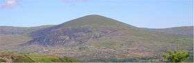
Moelfre is a hill in Wales on the far western edge of the Snowdonia National Park, 3 miles from the village of Dyffryn Ardudwy, 5 miles from the village of Llanbedr and about 10 miles from the town of Harlech. It forms part of the Rhinogydd range. Moelfre reaches a height of 589 metres.
Moelfre is a prominent peak that separates Cwm Nantcol from Ysgethin Valley.[2] Moelfre is also known for a legend of three women who worked on the Sabbath and were turned into standing stones.[3]
References
- 1 2 "Database of British and Irish Hills". Nov 2011. version 12.
- ↑ Gillham, John (2010). "Mountains of Snowdonia". Frances Lincoln Ltd. p. 297.
- ↑ Sikes, Wirt (1881). British goblins: Welsh folk lore, fairy mythology, legends and traditions. J. R. Osgood and company. p. 376.
This article is issued from Wikipedia - version of the 1/24/2016. The text is available under the Creative Commons Attribution/Share Alike but additional terms may apply for the media files.