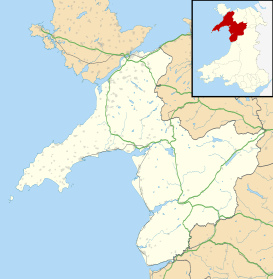
Harlech
| Harlech | |
 Harlech as viewed from the beach area, the Castle is located centre-left |
|
 Harlech |
|
| Population | 1,447 (2011 Census) |
|---|---|
| OS grid reference | SH581312 |
| Community | Harlech |
| Principal area | Gwynedd |
| Ceremonial county | Gwynedd |
| Country | Wales |
| Sovereign state | United Kingdom |
| Post town | HARLECH |
| Postcode district | LL46 |
| Dialling code | 01766 |
| Police | North Wales |
| Fire | North Wales |
| Ambulance | Welsh |
| EU Parliament | Wales |
| UK Parliament | Dwyfor Meirionnydd |
| Welsh Assembly | Dwyfor Meirionnydd |
Coordinates: 52°51′36″N 4°06′18″W / 52.860°N 4.105°W
Harlech (Welsh pronunciation: [ˈharlɛx]) is a town and seaside resort in Gwynedd, within the historic boundaries of Merionethshire in northwest Wales. Lying on Tremadog Bay and within the Snowdonia National Park, it has a population of 1,447, of whom 51% speak Welsh.[1] The town is in the unitary authority of Gwynedd which was formed in 1996. From 1974 to 1996 it was in the Meirionydd District of the 1974 County of Gwynedd, and before 1974 it was in the historic county of Merionethshire.
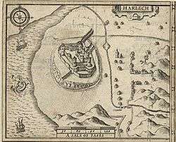
The town is best known for the landmark Harlech Castle, begun in 1283 by Edward I of England, captured by Owain Glyndŵr, and later the stronghold of Henry Tudor.[2] The castle was built next to the sea, but geological processes have changed the shape of the coastline, and the castle now lies on a cliff face, about half a mile (800 m) inland.[3] The town has since developed, with housing estates on the flat low town area and hillside properties in the high town around the shopping street, church, and castle. The two areas are linked by a steep and winding road called "Twtil".[4]
Etymology
The exact derivation of the name 'Harlech' is unclear. Some mostly older sources claim that it derives from Arddlech, i.e. ardd (high) + llech (rock),[5][6] referring to the prominent crag on which the castle stands. More recent sources tend to claim a simpler derivation, namely from the two Welsh words hardd (fair/fine) and llech.[7]
As late as the 19th century some texts referred to "Harddlech" and "Harddlech Castle",[8][9] and this name is used in the mid-19th century translation of the Mabinogion : "And one afternoon he was at Harddlech in Ardudwy, at a court of his. And they were seated upon the rock of Harddlech overlooking the sea." Contemporary documents from the time of the Mabinogion do not actually mention Harlech, referring only to Llywelyn building his castle "at Ardudwy"[10]
Governance
An electoral ward in the same name exists. This stretches to include Talsarnau Community. The total population of the ward taken at the 2011 census was 1,997.[11]
Transport
The town's railway station is served by the Cambrian Coast Line. It also contains Ffordd Pen Llech, a street which descends the rock spur to the north of the castle, and has the steepest signed gradient on a public road in the United Kingdom.
Educational facilities
Ysgol Ardudwy is the county secondary school for children between the ages of 11-16.
The town is also the home of Wales' only long term adult residential college, Coleg Harlech, also known as the "college of second chance."
Recreation
Theatr Harlech (formerly called Theatr Ardudwy) is located on the Coleg Harlech campus and stages a varied selection of plays, music, and films throughout the year.
Other attractions in Harlech include its beach backed with sand dunes and the famous Royal Saint David's Golf Club, a top course in Britain which hosted its fifth British Ladies Amateur in 2009.
The Rhinogydd (or Rhinogs) range of mountains rises to the east.
A World War II-era fighter aircraft was found on Harlech beach in 2007. The discovery of the Lockheed P-38 Lightning has been described as "one of the most important WWII finds in recent history". The International Group for Historic Aircraft Recovery (TIGHAR) are not divulging the precise location of the U.S. Army Air Forces aeroplane, known as the Maid of Harlech, but hope eventually to salvage the wreck.[12]
In traditional and popular culture
- In the second branch of the Mabinogi ("Branwen, Daughter of Llŷr"), Harlech is the seat of Bendigeidfran, Branwen's brother and king of the Isle of the Mighty.[13]
- The song Men of Harlech is associated with the town, and is traditionally said to describe events during the seven-year siege of the castle from 1461 to 1468.[14]
- Mari Strachan's 2009 novel The Earth Hums in B Flat is set in Harlech in the 1950s.[15]
Famous residents
- Owain Glyndŵr (1404–1409) - Welsh Rebellion Leader and the last Welshman to claim the title 'Prince of Wales'
- Ellis Wynne (1671–1734) - Welsh language author
- George Davison (1855–1930) - photographer
- Elinor Lyon (1921–2008) - children's writer
- Alfred Perceval Graves (1846–1931) - poet, bard and songwriter, and his large family, including his son, the poet Robert Graves, spent their summers in a large house called "Erinfa" to the north-east of Harlech. The family owned tracts of land, a school and several cottages nearby.[16]
Gallery
 Harlech Castle with flags at half mast after death of Queen Elizabeth the Queen Mother in 2002
 Harlech Castle gatehouse
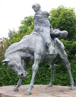 The Two Kings (sculptor Ivor Robert-Jones, 1984) near Harlech Castle, Wales. Bendigeidfran carries the body of his nephew Gwern
 Harlech Beach at low tide.
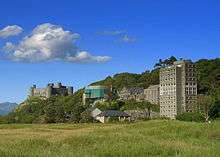 Harlech College with Harlech Castle in background
See also
- Morfa Harlech sand dunes
- Harlech Castle
- St. David's Hotel
- Lord Harlech
- HTV - Harlech Television
References
- ↑ "Town population and welsh speakers". Retrieved 2015-05-16.
- ↑ Memoirs of Owen Glendower, (Owain Glyndwr): with a sketch of the history of the ancient Britons, from the conquest of Wales by Edward the First, to the present time, illustrated with various notes, genealogical & topographical at Google Books
- ↑ Planet geography, p. 207, at Google Books
- ↑ Probably from the English 'Toothill', meaning "look-out hill".
- ↑ Notices Illustrative of Cambrian History and Antiquities, The New Monthly Magazine, Volume 10 - Page 307, 1818
- ↑ The Celtic Review: Volumes 9-10, Donald MacKinnon, E. C. Carmichael Watson, 1975
- ↑ Oxford Dictionary of British Place Names by Anthony David Mills, Oxford University Press 1991
- ↑ The History of the Princes, the Lords Marcher, and the Ancient Nobility of Powys Fadog, and the Ancient Lords of Arwystli, Cedewen, and Meirionydd :Volume 6, Jacob Youde William Lloyd, 1887
- ↑ The Poetical Works of Lewis Glyn Cothi: A celebrated bard,page 21, Lewis Glyn Cothi, 1837
- ↑ Brut y Tywysogion / Chronicle of the Princes, Red Book of Hergest, Thomas Jones, University of Wales Press, Cardiff 1955
- ↑ "Ward population 2011". Retrieved 16 May 2015.
- ↑ Charity hopes to lift World War II fighter plane from sea at walesonline.co.uk
- ↑ Ford, Patrick K. The Mabinogi and other Medieval Welsh Tales. Berkeley: University of California Press, 1977. pp. 57-72.
- ↑ The Oxford Companion to British History - Oxford University Press (1997) page 454; Dictionary of Ancient & Medieval Warfare by Matthew Bennett (2001)
- ↑ "What the blogs say about The Earth Hums in B Flat" at maristrachan.info
- ↑ Graves, R. P., Robert Graves: The assault heroic, Biography 1895-1926. p.67.
External links
| Wikimedia Commons has media related to Harlech. |
| Wikivoyage has a travel guide for Harlech. |
- Harlech Tourism Association
- Coleg Harlech
- Theatr Harlech
- Royal Saint David's Golf Club
- Aerial photograph of Harlech
- geograph.co.uk - photos of Harlech and surrounding area
