Mohler, Oregon
| Mohler, Oregon | |
|---|---|
| Unincorporated community | |
 Mohler, Oregon  Mohler, Oregon | |
| Coordinates: 45°42′25″N 123°51′47″W / 45.707°N 123.863°WCoordinates: 45°42′25″N 123°51′47″W / 45.707°N 123.863°W | |
| Country | United States |
| State | Oregon |
| County | Tillamook |
| Area | |
| • Land | 0.01 sq mi (0.03 km2) |
| Elevation | 20 ft (6 m) |
| Time zone | Pacific (PST) (UTC-8) |
| • Summer (DST) | PDT (UTC-7) |
| ZIP code | 97131 |
| Area code(s) | 503 and 971 |
Mohler is an unincorporated community in Tillamook County, Oregon, United States.[1] It is located east of U.S. Route 101 on Oregon Route 53.[2]
It was named after A. L. Mohler, who was once president of the Union Pacific Railroad.[3] The first post office in the area was established in 1897 and named "Balm".[4] It was located on Foley Creek about two miles southeast of present-day Mohler.[4] In 1911 the name was changed to Mohler at the request of E. E. Lytle, who built the Pacific Railway & Navigation Company line into that part of the county.[4] The post office was moved to the present locale of Mohler at the same time as the name change and operated there until 1959.[4]
References
- ↑ "Mohler". Geographic Names Information System. United States Geological Survey. November 28, 1980. Retrieved 2011-03-13.
- ↑ Oregon Atlas & Gazetteer (7th ed.). Yarmouth, Maine: DeLorme. 2008. p. 20. ISBN 0-89933-347-8.
- ↑ Tillamook County (December 18, 2002). "Mohler community plan" (PDF). Retrieved December 10, 2010.
- 1 2 3 4 McArthur, Lewis A.; McArthur, Lewis L. (2003) [1928]. Oregon Geographic Names (7th ed.). Portland, Oregon: Oregon Historical Society Press. p. 654. ISBN 978-0875952772.
Municipalities and communities of Tillamook County, Oregon, United States | ||
|---|---|---|
| Cities | 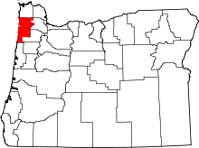 | |
| CDPs |
| |
| Unincorporated communities | ||
This article is issued from Wikipedia - version of the 7/31/2016. The text is available under the Creative Commons Attribution/Share Alike but additional terms may apply for the media files.