Tillamook County, Oregon
| Tillamook County, Oregon | |
|---|---|
|
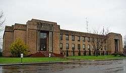
Tillamook County Courthouse in Tillamook | |
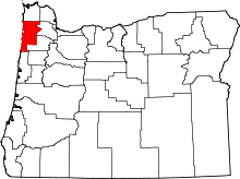 Location in the U.S. state of Oregon | |
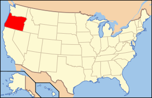 Oregon's location in the U.S. | |
| Founded | December 15, 1853 |
| Seat | Tillamook |
| Largest city | Tillamook |
| Area | |
| • Total | 1,333 sq mi (3,452 km2) |
| • Land | 1,103 sq mi (2,857 km2) |
| • Water | 230 sq mi (596 km2), 17% |
| Population (est.) | |
| • (2015) | 25,653 |
| • Density | 23/sq mi (9/km²) |
| Congressional district | 5th |
| Time zone | Pacific: UTC-8/-7 |
| Website |
www |
Tillamook County is a county located in the U.S. state of Oregon. As of the 2010 census, the population was 25,250.[1] The county seat is Tillamook.[2] The county is named for the Tillamook, a Native American tribe who were living in the area in the early 19th century at the time of European American settlement.
The Tillamook were the southernmost branch of the Coast Salish. They were separated from their more northern kinsmen by tribes speaking the Chinookian languages. The name Tillamook is of Chinook origin (a trade pidgin, which had developed along the lower Columbia.) According to Frank Boas,[3] "It [Tillamook] means the people of Nekelim. The latter name means the place of Elim, or in the Cathlamet dialect, the place of Kelim. The initial t of Tillamook is the plural article, the terminal ook the Chinook plural ending —uks." Since there was one village in the area of Nehalem bay; the area was referred to as Nekelim (Ne Elim=singular). There were at least four villages on the south Tillamook bay according to Lewis and Clark; the south bay was called "T-Elim-ook" (the plural of Elim), meaning many villages of Elim. (The Chinook word for water was "chuck" and the Salish word for wetland is "naslex". The popular translation of Tillamook as meaning "land of many waters" seems to be 20th-century fabrication used in the tourist industry.)
History
Tillamook County, the 12th county in Oregon to be organized, was established on December 15, 1853, when the Territorial Legislature approved an act to create the new county out of an area previously included in Clatsop, Yamhill and Polk counties. Boundary changes were enacted with Clatsop County (1855, 1870, and 1893), Lincoln County in 1893, Washington County (1893, 1898), and Yamhill County (1887).
The Coast Range behind Tillamook was the scene of a repeated series of forest fires called the Tillamook Burn between 1933 and 1951. In 1948, a state ballot approved the sale of bonds to buy the burned-over areas and have the state rehabilitate the lands. The state lands were renamed the Tillamook State Forest by governor Tom McCall on July 18, 1973. By the end of the 20th century, the replanted growth was considered mature enough to be commercially harvested.
Naval Air Station Tillamook
The Tillamook airbase for blimps was commissioned on December 1, 1942, as U.S. Naval Air Station Tillamook. The two wooden hangars used to house these airships were decommissioned after World War II and deeded to Tillamook County. One of the hangars (Hangar B) is a national historic landmark and the location of the Tillamook Air Museum. The other hangar, (Hangar A) burned down in 1992.
The U.S. Mount Hebo Air Force Station was a Cold War air defense installation from 1956 to 1980. Located south of Tillamook, at the top of 3,154-foot (961 m) high Mount Hebo, Air Force radars operated by the 689th Radar Squadron and the 14th Missile Warning Squadron were essential parts of the nation's integrated air defenses. The large radomes protecting the radars from adverse weather effects could be seen silhouetted against the sky from most of Tillamook County.
Development along U.S. Route 101 to the north of Tillamook during the last part of the 20th century has blocked part of the flood plain of the Wilson River, contributing to repeated winter flooding in the city.
Geography

According to the U.S. Census Bureau, the county has a total area of 1,333 square miles (3,450 km2), of which 1,103 square miles (2,860 km2) is land and 230 square miles (600 km2) (17%) is water.[4] At 3,706 feet (1130 m) in elevation, Rogers Peak is the highest point in the county and the highest in the Northern Oregon Coast Range.[5]
Adjacent counties
- Clatsop County - north
- Washington County - east
- Yamhill County - east
- Polk County - southeast
- Lincoln County - south
National protected areas
- Cape Meares National Wildlife Refuge
- Nestucca Bay National Wildlife Refuge
- Oregon Islands National Wildlife Refuge (part)
- Siuslaw National Forest (part)
- Three Arch Rocks National Wildlife Refuge
Demographics
| Historical population | |||
|---|---|---|---|
| Census | Pop. | %± | |
| 1860 | 95 | — | |
| 1870 | 408 | 329.5% | |
| 1880 | 970 | 137.7% | |
| 1890 | 2,932 | 202.3% | |
| 1900 | 4,471 | 52.5% | |
| 1910 | 6,266 | 40.1% | |
| 1920 | 8,810 | 40.6% | |
| 1930 | 11,824 | 34.2% | |
| 1940 | 12,263 | 3.7% | |
| 1950 | 18,606 | 51.7% | |
| 1960 | 18,955 | 1.9% | |
| 1970 | 17,930 | −5.4% | |
| 1980 | 21,164 | 18.0% | |
| 1990 | 21,570 | 1.9% | |
| 2000 | 24,262 | 12.5% | |
| 2010 | 25,250 | 4.1% | |
| Est. 2015 | 25,653 | [6] | 1.6% |
| U.S. Decennial Census[7] 1790-1960[8] 1900-1990[9] 1990-2000[10] 2010-2015[1] | |||
2000 census
As of the census[11] of 2000, there were 24,262 people, 10,200 households, and 6,793 families residing in the county. The population density was 22 people per square mile (8/km²). There were 15,906 housing units at an average density of 14 per square mile (6/km²). The racial makeup of the county was 93.86% White, 0.22% Black or African American, 1.19% Native American, 0.65% Asian, 0.21% Pacific Islander, 1.89% from other races, and 1.98% from two or more races. 5.13% of the population were Hispanic or Latino of any race. 20.1% were of German, 13.3% English, 10.7% American and 8.6% Irish ancestry.
There were 10,200 households out of which 24.6% had children under the age of 18 living with them, 54.8% were married couples living together, 7.7% had a female householder with no husband present, and 33.4% were non-families. 27.9% of all households were made up of individuals and 12.6% had someone living alone who was 65 years of age or older. The average household size was 2.33 and the average family size was 2.82.
In the county, the population was spread out with 22.2% under the age of 18, 6.5% from 18 to 24, 23.5% from 25 to 44, 28% from 45 to 64, and 19.8% who were 65 years of age or older. The median age was 44 years. For every 100 females there were 100.4 males. For every 100 females age 18 and over, there were 98.1 males.
The median income for a household in the county was $34,269, and the median income for a family was $40,197. Males had a median income of $31,509 versus $21,555 for females. The per capita income for the county was $19,052. About 8.1% of families and 11.4% of the population were below the poverty line, including 13.4% of those under age 18 and 8.1% of those age 65 or over.
2010 census
As of the 2010 United States Census, there were 25,250 people, 10,834 households, and 6,930 families residing in the county.[12] The population density was 22.9 inhabitants per square mile (8.8/km2). There were 18,359 housing units at an average density of 16.7 per square mile (6.4/km2).[13] The racial makeup of the county was 91.5% white, 1.0% American Indian, 0.9% Asian, 0.3% black or African American, 0.2% Pacific islander, 3.6% from other races, and 2.4% from two or more races. Those of Hispanic or Latino origin made up 9.0% of the population.[12] In terms of ancestry, 26.9% were German, 17.2% were English, 12.1% were Irish, and 5.2% were American.[14]
Of the 10,834 households, 23.8% had children under the age of 18 living with them, 51.6% were married couples living together, 8.1% had a female householder with no husband present, 36.0% were non-families, and 29.1% of all households were made up of individuals. The average household size was 2.29 and the average family size was 2.79. The median age was 47.5 years.[12]
The median income for a household in the county was $39,412 and the median income for a family was $50,779. Males had a median income of $39,019 versus $32,688 for females. The per capita income for the county was $22,824. About 12.8% of families and 16.9% of the population were below the poverty line, including 26.8% of those under age 18 and 10.2% of those age 65 or over.[15]
Economy
Agriculture
Dairy farming is one of the county's largest agricultural occupations. The Tillamook Cheese Factory is the county's largest business and the largest private employer. Tillamook dairy products are available throughout the west and the rest of the country.
Timber
The state of Oregon owns 44% of the land inside the county boundaries, mostly as part of the Tillamook State Forest. The State Forest was created as a result of the 355,000-acre (144,000 ha) Tillamook Burn. The reforested burn is rapidly maturing, and there is local expectation that it will assist in the recovery of the local timber industry. Three lumber mills currently operate in Tillamook County—one at Garibaldi, one in Tillamook, and one south of Tillamook at the former Naval Air Station.
Tourism
The County's scenic coastline, which includes four bays and nine rivers, helps the tourist industry. U.S. Route 101, traveling the length of the Oregon Coast, brings many travelers through the county by car and bike. The coast also provides locations for vacation homes for inhabitants of nearby Portland, Oregon and the Willamette Valley.
Fishing
Fishing is a very important part of the economy. Oysters are farmed in the bay and keep the bay fairly clean. Sport fishing makes up most of the rest. With nine rivers salmon is the biggest with nearly recovered runs as salmon had to be given away to the food bank. Tillamook County is the first in the continental United States to be declared ready for a tsunami. This designation was given by the National Oceanic and Atmospheric Administration after the county paid $15,000 for 27 warning sirens and an emergency radio system.
Politics
| Year | Republican | Democratic |
|---|---|---|
| 2016 | 47.4% 6,538 | 41.8% 5,768 |
| 2012 | 45.4% 5,684 | 50.3% 6,293 |
| 2008 | 43.3% 5,757 | 53.2% 7,072 |
| 2004 | 50.2% 7,003 | 48.4% 6,750 |
| 2000 | 46.7% 5,775 | 46.6% 5,762 |
| 1996 | 34.3% 3,884 | 51.0% 5,775 |
| 1992 | 29.2% 3,359 | 43.9% 5,040 |
| 1988 | 42.7% 4,297 | 54.9% 5,529 |
| 1984 | 51.1% 5,267 | 48.4% 4,988 |
| 1980 | 41.6% 4,123 | 45.7% 4,521 |
| 1976 | 45.5% 4,033 | 50.3% 4,456 |
| 1972 | 51.2% 4,120 | 44.1% 3,544 |
| 1968 | 44.7% 3,261 | 49.5% 3,609 |
| 1964 | 30.6% 2,318 | 69.3% 5,246 |
| 1960 | 48.9% 3,935 | 50.9% 4,098 |
Despite voting for Democrats in 10 of the last 15 presidential elections, Tillamook county has remained quite competitive over the last half century. Since 1968 no candidate has received over 55% of the vote, with the highest being Michael Dukakis in 1988.
Transportation
Communities
Cities
Census-designated places
- Bayside Gardens
- Beaver
- Cape Meares
- Cloverdale
- Hebo
- Idaville
- Neahkahnie Beach
- Neskowin
- Netarts
- Oceanside
- Pacific City
Unincorporated communities
- Barview
- Bayocean
- Brighton
- Castle Rock
- Dolph
- Fairview
- Foss
- Hemlock
- Hobsonville
- Idiotville
- Jordan Creek
- Lees Camp
- Manhattan Beach
- Meda
- Mohler
- Nedonna Beach
- Oretown
- Pleasant Valley
- Sandlake
- Tierra Del Mar
- Twin Rocks
- Watseco
- Woods
Notable people
- Dennis Awtrey, retired National Basketball Association player[17]
See also
References
- 1 2 "State & County QuickFacts". United States Census Bureau. Retrieved November 15, 2013.
- ↑ "Find a County". National Association of Counties. Retrieved 2011-06-07.
- ↑ Boas, Frank (Jan–Mar 1898). "Traditions of the Tillamook Indians". The Journal of American Folklore. 11 (40): 23–38. doi:10.2307/533608. JSTOR 533608.
- ↑ "2010 Census Gazetteer Files". United States Census Bureau. August 22, 2012. Retrieved February 28, 2015.
- ↑ Peakbagger.com: Rogers Peak
- ↑ "County Totals Dataset: Population, Population Change and Estimated Components of Population Change: April 1, 2010 to July 1, 2015". Retrieved July 2, 2016.
- ↑ "U.S. Decennial Census". United States Census Bureau. Retrieved February 28, 2015.
- ↑ "Historical Census Browser". University of Virginia Library. Retrieved February 28, 2015.
- ↑ Forstall, Richard L., ed. (March 27, 1995). "Population of Counties by Decennial Census: 1900 to 1990". United States Census Bureau. Retrieved February 28, 2015.
- ↑ "Census 2000 PHC-T-4. Ranking Tables for Counties: 1990 and 2000" (PDF). United States Census Bureau. April 2, 2001. Retrieved February 28, 2015.
- ↑ "American FactFinder". United States Census Bureau. Retrieved 2008-01-31.
- 1 2 3 "DP-1 Profile of General Population and Housing Characteristics: 2010 Demographic Profile Data". United States Census Bureau. Retrieved 2016-02-23.
- ↑ "Population, Housing Units, Area, and Density: 2010 - County". United States Census Bureau. Retrieved 2016-02-23.
- ↑ "DP02 SELECTED SOCIAL CHARACTERISTICS IN THE UNITED STATES – 2006-2010 American Community Survey 5-Year Estimates". United States Census Bureau. Retrieved 2016-02-23.
- ↑ "DP03 SELECTED ECONOMIC CHARACTERISTICS – 2006-2010 American Community Survey 5-Year Estimates". United States Census Bureau. Retrieved 2016-02-23.
- ↑ http://uselectionatlas.org/RESULTS/
- ↑ Schoenfeld, Bruce (June–July 2014). "In Praise of the American Beach Town". National Geographic Traveller.
External links
| Wikimedia Commons has media related to Tillamook County, Oregon. |
- Tillamook County, Oregon (official website)
Coordinates: 45°28′N 123°42′W / 45.46°N 123.70°W
Municipalities and communities of Tillamook County, Oregon, United States | ||
|---|---|---|
| Cities | | |
| CDPs |
| |
| Unincorporated communities | ||