Mole Hill (Virginia)
Mole Hill is a rounded hill composed of basalt, a volcanic rock, formed during the Eocene epoch of the Paleogene period. It is the eroded remnant of what was an active volcano approximately 47 million years ago, making it one of the youngest volcanos on the east coast of North America. It is located west of Harrisonburg, VA, in Rockingham County.[1]
Description
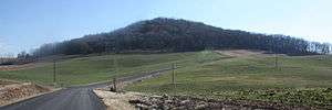
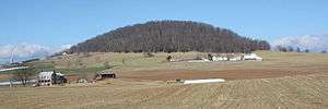
Mole Hill is an isolated, rounded, tree-covered hill in an otherwise relatively flat valley, surrounded by farmland.
The basalt itself, outcropping at the crest of the hill, is "dark greenish gray to grayish black, medium grained, and moderately porphyritic. It is an olivine-spinel basalt with abundant large pale green pyroxene and minor yellow-brown olivine phenocrysts.".[2] The basalt intrudes through the Ordovician Beekmantown Group of carbonate rocks.
Age
The basalt at Mole Hill (and other igneous dikes in the area) was originally thought to be of Paleozoic age by relative age dating using cross-cutting relationships.[1] In 1969, Fullagar and Bottino used K-Ar and Rb-Sr radiometric dating techniques to date rocks that they thought were temporally related to the Devonian Tioga Bentonite, but discovered that the rocks were actually a much younger age of approximately 47 million years, placing them in the Eocene.[3]
Trimble Knob, located in Highland County, is geologically similar to Mole Hill and thought to be contemporaneous with it, along with other intrusive igneous rocks near Ugly Mountain in Pendleton County, West Virginia.[1]
See also
References
- 1 2 3 Jonathan L. Tso; Ronald R. McDowell; Katharine Lee Avary; David L. Matchen & Gerald P. Wilkes (2004). "Middle Eocene Igneous Rocks in the Valley and Ridge of Virginia and West Virginia". Circular 1264. United States Geological Survey.
- ↑ Gathright, T. M., and Frischmann, P. S., 1986, Geology of the Harrisonburg and Bridgewater Quadrangles, Virginia, VA Division of Mineral Resources Publication 60
- ↑ Fullagar, P.D., and Bottino, M.L., 1969. Tertiary felsite intrusions in the Valley and Ridge province, Virginia: Geological Society of America Bulletin, v. 80, no. 9, p. 1853–1858. (Abstract)
Coordinates: 38°26′55″N 78°57′12″W / 38.44861°N 78.95333°W