Longview, Washington
| City of Longview | |
|---|---|
| City | |
|
Downtown Longview | |
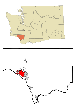 Location of Longview, Washington | |
| Coordinates: 46°8′34″N 122°57′20″W / 46.14278°N 122.95556°W | |
| Country | United States |
| State | Washington |
| County | Cowlitz |
| Settled | 1850s |
| Incorporated | February 14, 1924 |
| Government | |
| • Type | Council-Manager |
| • City Manager | David Campbell |
| • Mayor | Don Jensen |
| Area[1] | |
| • City | 14.79 sq mi (38.31 km2) |
| • Land | 14.49 sq mi (37.53 km2) |
| • Water | 0.30 sq mi (0.78 km2) |
| Elevation | 20 ft (6 m) |
| Population (2010)[2] | |
| • City | 36,648 |
| • Estimate (2015)[3] | 36,848 |
| • Density | 2,529.2/sq mi (976.5/km2) |
| • Metro | 103,468 (US: 346th) |
| Time zone | PST (UTC-8) |
| • Summer (DST) | PDT (UTC-7) |
| ZIP codes | 98632 |
| Area code | 360 |
| FIPS code | 53-40245 |
| GNIS feature ID | 1506304[4] |
| Website | www.mylongview.com |
Longview is a city in Cowlitz County, Washington, United States. It is the principal city of the "Longview, Washington Metropolitan Statistical Area", which encompasses all of Cowlitz County. Longview's population was 36,648 at the time of the 2010 census and it is the largest city in Cowlitz County. The city is located in southwestern Washington, at the junction of the Cowlitz and Columbia rivers. Longview shares a border with Kelso to the east, which is the county seat.
The Cowlitz Indian Tribe, a federally recognized tribe of Cowlitz people, is headquartered in Longview.[5]
The Long-Bell Lumber Company, led by Robert A. Long, decided in 1918 to buy a great expanse of timberland in Cowlitz County. A total of 14,000 workers were needed to run the two large mills as well as lumber camps that were planned. The number of workers needed was more than a lumber town, or the nearest town, could provide. Long planned and built a complete city in 1921 that could support a population of up to 50,000 and provide labor for the mills as well as attracting other industries. Several buildings in the city were built from Long's private funds.[6]
History
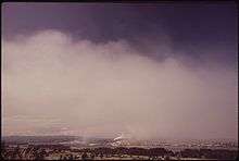
Longview was the location of Mount Coffin, an ancestral burial ground for the local indigenous people.
The Longview area was first settled by European-Americans, led by pioneers Harry and Rebecca Jane Huntington, in 1849. The area was named Monticello in honor of Thomas Jefferson's home in Virginia. In 1852 a group assembled in what would be called the "Monticello Convention" to petition Congress for statehood to be called "Columbia". Congress agreed to statehood but as Washington, after President Washington, to avoid confusion with the District of Columbia. A monument to the convention is located near the Longview Civic Center.[7]
The area remained sparsely populated for nearly 60 years, consisting mostly of farmland and wilderness. In 1918, Missouri timber baron Robert A. Long (1850–1934) decided to move his operation out to the west coast, owing to the Long-Bell Lumber Company's dwindling supplies in the south. By 1921, Wesley Vandercook had decided to build a mill near the small town of Kelso, Washington. It was apparent that Kelso, with a population of barely 2,000 would not be able to support the approximately 14,000 men that would be required to run the mill.
The Long-Bell company contracted with George Kessler, a city planner based in St. Louis, to build the city that would support the two mills that were now planned. Longview was officially incorporated on February 14, 1924. At the time of its conception, Longview was the only planned city of its magnitude to have ever been conceived of and built entirely with private funds. A number of prominent buildings in Longview were purchased with R. A. Long's personal funds, including R. A. Long High School, the Longview Public Library, the YMCA building and the Monticello Hotel.
National Register of Historic Places
A park, a bridge, and many buildings are listed on the National Register of Historic Places, along with the Civic Center, that is a National Register Historic District.[8]
|
|
|
Government
The city has seven council members and a mayor as well as a city manager.[9]
Geography
According to the United States Census Bureau, the city has a total area of 14.79 square miles (38.31 km2), of which 14.49 square miles (37.53 km2) is land and 0.30 square miles (0.78 km2) is water.[1]
The Lewis and Clark Bridge spans the Columbia River, linking Longview to Rainier, Oregon. It is the only bridge spanning the river between Portland and Astoria, Oregon.
Climate
Longview is in a small gorge, so its climate varies from its close neighbor, Portland. Longview is generally about 7 °F (4 °C) cooler than Portland. Located about 80 miles (130 km) inland across a stretch of relatively flat ground, the Longview skies can be overcast due to moisture from the Pacific Coast marine layer. The Columbia River gorge permits an exchange of air between eastern and western Washington. The direction and speed of air movement through the gorge is determined primarily by the pressure gradient between the eastern and western slopes of the mountains. Due to the gorge-like effect, marine pushes on summer evenings can frequently reach gusts up to 30 to 40 miles per hour (48 to 64 km/h) There have been gusts of up to 90 to 100 miles per hour (140 to 160 km/h), and over 100 miles per hour (160 km/h) at higher elevations.
Fall is usually cooler but foggy; on some days the fog never clears. By early-to-mid November, rainfall begins in typical Northwest fashion. Winter tends to be chilly and rainy, with occasional violent windstorms or spates of unusually warm—65 to 70 °F (18 to 21 °C)—temperatures. This is due to extremely warm air coming from the Pineapple Express which can drop 3 to 6 inches (76 to 152 mm) of rain in a matter of days. Each year there are one or two snowfalls, typically less than 6 inches (15 cm) but up to 1 metre (3 ft) in the surrounding foothills. Spring is warmer, but still a little wet; this is the most common time for the occasional thunderstorms.[10]
| Climate data for Longview | |||||||||||||
|---|---|---|---|---|---|---|---|---|---|---|---|---|---|
| Month | Jan | Feb | Mar | Apr | May | Jun | Jul | Aug | Sep | Oct | Nov | Dec | Year |
| Record high °F (°C) | 65 (18) |
73 (23) |
81 (27) |
90 (32) |
99 (37) |
100 (38) |
105 (41) |
108 (42) |
104 (40) |
90 (32) |
77 (25) |
66 (19) |
108 (42) |
| Average high °F (°C) | 45.3 (7.4) |
50.4 (10.2) |
55.2 (12.9) |
60.8 (16) |
67.2 (19.6) |
71.8 (22.1) |
77.6 (25.3) |
77.9 (25.5) |
73.3 (22.9) |
63.1 (17.3) |
52.2 (11.2) |
46.2 (7.9) |
61.8 (16.6) |
| Average low °F (°C) | 33.1 (0.6) |
34.3 (1.3) |
36.4 (2.4) |
39.2 (4) |
43.7 (6.5) |
48.4 (9.1) |
51.5 (10.8) |
51.8 (11) |
48.8 (9.3) |
43.4 (6.3) |
37.9 (3.3) |
34.6 (1.4) |
41.9 (5.5) |
| Record low °F (°C) | −6 (−21) |
2 (−17) |
19 (−7) |
24 (−4) |
27 (−3) |
30 (−1) |
32 (0) |
35 (2) |
29 (−2) |
24 (−4) |
8 (−13) |
4 (−16) |
−6 (−21) |
| Average precipitation inches (mm) | 6.28 (159.5) |
4.79 (121.7) |
4.7 (119) |
3.35 (85.1) |
2.61 (66.3) |
2.07 (52.6) |
0.81 (20.6) |
1.3 (33) |
2.06 (52.3) |
3.98 (101.1) |
6.65 (168.9) |
7.11 (180.6) |
45.72 (1,161.3) |
| Average snowfall inches (cm) | 3.2 (8.1) |
0.8 (2) |
0.4 (1) |
0 (0) |
0 (0) |
0 (0) |
0 (0) |
0 (0) |
0 (0) |
0 (0) |
0.2 (0.5) |
0.6 (1.5) |
5.1 (13) |
| Average precipitation days (≥ 0.01 inch) | 21 | 18 | 20 | 17 | 13 | 11 | 5 | 6 | 9 | 15 | 20 | 22 | 177 |
| Source: [11] | |||||||||||||
Demographics
| Historical population | |||
|---|---|---|---|
| Census | Pop. | %± | |
| 1930 | 10,652 | — | |
| 1940 | 12,385 | 16.3% | |
| 1950 | 20,339 | 64.2% | |
| 1960 | 23,349 | 14.8% | |
| 1970 | 28,373 | 21.5% | |
| 1980 | 31,052 | 9.4% | |
| 1990 | 31,499 | 1.4% | |
| 2000 | 34,660 | 10.0% | |
| 2010 | 36,648 | 5.7% | |
| Est. 2015 | 36,848 | [12] | 0.5% |
| U.S. Decennial Census[13] 2015 Estimate[3] | |||
2010 census
As of the census[2] of 2010, there were 36,648 people, 15,281 households, and 9,086 families residing in the city. The population density was 2,529.2 inhabitants per square mile (976.5/km2). There were 16,380 housing units at an average density of 1,130.4 per square mile (436.4/km2). The racial makeup of the city was 86.0% White, 0.9% African American, 1.7% Native American, 2.2% Asian, 0.3% Pacific Islander, 4.7% from other races, and 4.2% from two or more races. Hispanic or Latino of any race were 9.7% of the population.
There were 15,281 households of which 29.1% had children under the age of 18 living with them, 40.5% were married couples living together, 13.4% had a female householder with no husband present, 5.6% had a male householder with no wife present, and 40.5% were non-families. 33.6% of all households were made up of individuals and 15.4% had someone living alone who was 65 years of age or older. The average household size was 2.34 and the average family size was 2.94.
The median age in the city was 39.6 years. 23.2% of residents were under the age of 18; 9.2% were between the ages of 18 and 24; 23.6% were from 25 to 44; 26.2% were from 45 to 64; and 17.5% were 65 years of age or older. The gender makeup of the city was 48.1% male and 51.9% female.
2000 census
As of the census of 2000, there were 34,660 people, 14,066 households, and 8,931 families residing in the city. The population density was 2,530.0 people per square mile (976.8/km²). There were 15,225 housing units at an average density of 1,111.4 per square mile (429.1/km²). The racial makeup of the city was 89.35% White, 0.72% African American, 1.76% Native American, 2.17% Asian, 0.13% Pacific Islander, 2.96% from other races, and 2.92% from two or more races. Hispanic or Latino of any race were 5.82% of the population. 17.3% were of German, 11.2% English, 10.3% United States or American, 8.5% Irish and 7.3% Norwegian ancestry. 92.4% spoke English and 4.9% Spanish as their first language.
There were 14,066 households out of which 30.9% had children under the age of 18 living with them, 46.5% were married couples living together, 12.3% had a female householder with no husband present, and 36.5% were non-families. 30.1% of all households were made up of individuals and 12.4% had someone living alone who was 65 years of age or older. The average household size was 2.40 and the average family size was 2.96.
In the city the age distribution of the population shows 26.0% under the age of 18, 8.9% from 18 to 24, 27.1% from 25 to 44, 22.6% from 45 to 64, and 15.4% who were 65 years of age or older. The median age was 37 years. For every 100 females there were 93.2 males. For every 100 females age 18 and over, there were 90.0 males.
The median income for a household in the city was $35,171, and the median income for a family was $43,869. Males had a median income of $38,972 versus $26,625 for females. The per capita income for the city was $18,559. About 12.3% of families and 16.7% of the population were below the poverty line, including 25.0% of those under age 18 and 6.8% of those age 65 or over.
Rank in state size
The city of Longview ranks 28 out of 281 in size.[14]
Economy
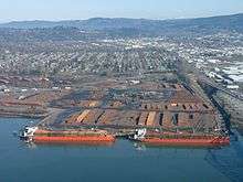
Manufacturing
Manufacturing in Longview accounts for 19% of the employment and easy access to the Columbia River, Interstate 5, and the west coast railways has attracted a rapidly diversifying manufacturing base. The abundance of timber around Longview provides the city's former two largest employers, Weyerhaeuser and Kapstone with timber products. Other major manufacturers in Longview include NORPAC (newsprint), Solvay Chemicals (hydrogen peroxide), and PPG Industries (Acquired Equa-Chlor in 2011).[15] Smaller operations include Epson Toyocom, Northwest Hardwoods, Caffall Brothers, Peterson Manufacturing, JM Huber, Specialty Minerals, HASA and the Simpson Timber Company.[16]
Marine transportation
The Port of Longview, established in 1921, has eight marine terminals handling a wide range of cargo from windmills, pencil pitch, calcined coke, pulp bales, lumber, grain, logs and steel. The Port is 66 miles (106 km) from the Pacific Ocean.
Sports
The Cowlitz Black Bears baseball team call Longview and Kelso home. The Black Bears play in the West Coast League, an independent summer baseball league with teams from Washington, Oregon, and British Columbia. The team plays at David Story Field on the Lower Columbia College campus.[17]
Parks and recreation
.jpg)
Longview has a variety of parks and recreation facilities. Longview Parks and Recreation[18] maintains the local parks, including the popular Lake Sacajawea. Dozens of other parks exist within city limits with walking trails, sport fields, dog-friendly areas, children's play areas, and other features. Both Longview and its neighbor city, Kelso, are home to skateparks.[19] Two athletic clubs exist, including the YMCA and Mint Valley Racquet and Fitness. Golf is also a popular sport in the local area, with the Longview Country Club, Mint Valley, among others.
Education
Longview is served by eight public elementary schools (Columbia Heights, Columbia Valley Gardens, Kessler, Mint Valley, Northlake, Olympic, Robert Gray, and Saint Helens), three public middle schools (Cascade, Monticello, and Mount Solo), and two public high schools (R. A. Long and Mark Morris).
Longview is also served by two religious based schools. The Saint Rose Catholic school serves kindergarten through eighth grade. Three Rivers Christian School currently operates under two campuses. One at Northlake Baptist serving preschool through sixth grade, and One at New life Fellowship which serves seventh through twelfth grades.
Lower Columbia College (LCC), based in Longview, was established in 1934.
Media
Radio
- KBAM AM 1270 (Classic Country)
- KEDO AM 1400 (Talk radio)
- KLOG AM 1490 (Classic Hits)
- KJVH FM 89.5 (Christian radio)
- KLWO FM 90.3 (Contemporary Christian)
- KLYK FM 94.5 (Hot Adult Contemporary)
- KPPK FM 98.3 "The Peak" (Adult hits)
- KRQT FM 107.1 "Rocket 107" (Classic rock)
- KUKN FM 105.5 (Country)
- K268BN FM 101.5 "The Wave" (Classic rock)
- (Simulcast as KUKN-HD2 FM 105.5)
Newsprint
- The Daily News – Longview's primary newspaper, won a 1981 Pulitzer Prize for its coverage of the Mount St. Helens eruption.[20]
- Columbia River Reader – A monthly community newspaper.
- Valley Bugler – A monthly "good news" and community events paper that grew out of the now defunct Castle Rock Advocate in 1998.
Television
- KLTV – Local public-access television cable TV channel, which has its headquarters in downtown Longview, at the corner of 12th Avenue and Washington Way.
Transportation
Longview is served by State Route 4 and State Route 432, which connect it to nearby Kelso.
The city is also served by RiverCities Transit, a local bus system that travels between Kelso and Longview.
Tourism
Longview is a gateway to the Mount St. Helens National Volcanic Monument, and tourism is playing an increasingly important role in the area's economy.
Nutty Narrows Bridge
Longview is home to the famous Nutty Narrows Bridge built in 1963 by Amos Peters. For many years, it was the only bridge in the world designed and built strictly for squirrels. The bridge was built in 1963 and its purpose was to avoid squirrel casualties on the busy streets beneath.[21]
Longview began a new annual festival, known as Squirrel Fest, in 2011.[22] As part of the festival, a new squirrel bridge has been unveiled each year, and as of 2014, there are now four squirrel bridges in the city.[23]
Recognition
In 2012, Forbes listed Longview as one of The United States' prettiest cities.[24]
The Green Day song "Longview" from their album Dookie is named after the town.[25]
Notable people
- Bud Black, manager of the San Diego Padres
- Steve De Jarnatt, director of cult films Miracle Mile and Cherry 2000[26]
- James Phillip Fleming, recipient of the Medal of Honor for heroic action as a United States Air Force helicopter pilot during the Vietnam War, 1968[27]
- David Korten, author of When Corporations Rule the World
- Arthur "Spud" Melin, co-inventor of the Hula Hoop, and co-founder of Wham-O.
- Hal Riney, American advertising executive inducted into the Advertising Hall of Fame in 2001
- Jason Schmidt, pitcher for the Los Angeles Dodgers, born in Lewiston, Idaho but was raised in Kelso and graduated from Kelso High School[28]
- Sid Snyder, Washington state legislator and businessman
- Rick Sweet, Louisville Bats Minor League Baseball Manager
- Moulton Taylor, inventor of the Aerocar, the first practical flying automobile.
- Brian Thompson, actor known for his work in action films and television series.
Sister cities
Longview has two sister cities:[29][30][31]
Gallery
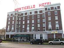 The Monticello Hotel, on the Civic Circle
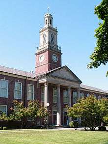 R. A. Long High School, constructed in 1927
 Bust of Robert A. Long, in front of the Monticello Hotel
Notes
- 1 2 "US Gazetteer files 2010". United States Census Bureau. Retrieved 2012-12-19.
- 1 2 "American FactFinder". United States Census Bureau. Retrieved 2012-12-19.
- 1 2 "Annual Estimates of the Resident Population for Incorporated Places: April 1, 2010 to July 1, 2015". United States Census Bureau. Retrieved May 27, 2016.
- ↑ "US Board on Geographic Names". United States Geological Survey. 2007-10-25. Retrieved 2008-01-31.
- ↑ "Tribal Directory." National Congress of American Indians. Retrieved September 29, 2013.
- ↑ -Beginning of Longview
- ↑ "Our Community: History". City of Longview. Retrieved July 3, 2012.
- ↑ National Register of Historic Places listings in Cowlitz County, Washington NRHP listings for Longview
- ↑ -government
- ↑ -Weather:"EAST OLYMPIC-CASCADE FOOTHILLS"
- ↑ "LONGVIEW, WASHINGTON (454769)". Western Regional Climate Center. Retrieved November 15, 2015.
- ↑ "Annual Estimates of the Resident Population for Incorporated Places: April 1, 2010 to July 1, 2015". Retrieved July 2, 2016.
- ↑ "U.S. Decennial Census". Census.gov. Retrieved June 6, 2013.
- ↑ - Economy
- ↑
- ↑ Manufacturing and economy- Retrieved September 8, 2011
- ↑ Cowlitz Black Bears Web Site
- ↑ "Longview Parks and Recreation". Longview Parks and Recreation
- ↑ "Skate Park Wrapping Up". The Daily News. Retrieved November 12, 2009.
- ↑ Bud May (May 13, 2000). "A witness to the eruption, journalist's life was changed forever". Seattle Post-Intelligencer. Retrieved December 18, 2011.
- ↑ -Squirrel bridge
- ↑ http://tdn.com/news/local/locals-visitors-go-nuts-for-squirrel-fest/article_3225f9ec-c09c-11e0-a1ff-001cc4c03286.html
- ↑ http://tdn.com/news/local/longview-s-fourth-squirrel-bridge-to-be-installed-june/article_0481df5c-f1d0-11e3-8eef-0019bb2963f4.html
- ↑ Giuffo, John. "America's Prettiest Towns". Forbes. Retrieved October 5, 2015.
- ↑ https://twitter.com/BJAofficial/status/35415649631223808
- ↑ Mathieu, Stephanie (December 10, 2006). "Man of direction—Longview's Steve De Jarnatt sprints to fame in film". TDN.com. The Daily News (Longview). Retrieved January 8, 2014.
- ↑ James Fleming's Medal of Honor Citation
- ↑ Jason Schmidt
- ↑ "History of Sister City Relationship with Wako, Japan". Washington Lieutenant Governor's Office.
- ↑ "Sister Cities, Counties, States and Ports". WCity of Longview.
- ↑ -Sister city
External links
Coordinates: 46°08′34″N 122°57′20″W / 46.142733°N 122.955636°W

