Pacific Northwest
The Pacific Northwest (in the United States, commonly abbreviated as PNW), sometimes referred to as Cascadia, is a geographic region in western North America bounded by the Pacific Ocean to the west and loosely, by the Rocky Mountains on the east. Though no agreed boundary exists, a common conception includes the U.S. states of Oregon and Washington and the Canadian province of British Columbia. Broader conceptions reach north into Alaska and Yukon, south into far northern California and east to include Idaho, Western Montana and western Wyoming, i.e., to the Continental Divide. Narrower conceptions may be limited to the northwestern US or to the coastal areas west of the Cascade and Coast mountains. The variety of definitions can be attributed to partially overlapping commonalities of the region's history, geography, society, and other factors.
The Northwest Coast is the coastal region of the Pacific Northwest and the Northwest Plateau (also commonly known as "the Interior" in British Columbia[1] and the Inland Empire in the United States) is the inland region. The term "Pacific Northwest" should not be confused with the Northwest Territory (also known as the Great Northwest, a historical term in the United States) or the Northwest Territories of Canada.
The region's largest metropolitan areas are Greater Seattle, Washington, with 3.7 million people;[2] Greater Vancouver, British Columbia, with 2.4 million people;[3] and Greater Portland, Oregon, with 2.4 million people.[4]
A key aspect of the Pacific Northwest is the US–Canada international border, which the United States and the United Kingdom established at a time when the region's inhabitants were composed mostly of indigenous peoples. The border — in two sections, along the 49th parallel south of British Columbia and the Alaska Panhandle west of northern British Columbia — has had a powerful effect on the region. According to Canadian historian Ken Coates, the border has not merely influenced the Pacific Northwest—rather, "the region's history and character have been determined by the boundary."[5]
Definition

Definitions of the Pacific Northwest region vary, and there is no commonly agreed-upon boundary, even among Pacific Northwesterners.[7][8] A common conception of the Pacific Northwest includes the U.S. states of Oregon and Washington as well as the Canadian province of British Columbia.[5] This definition is often restricted further to include only the coastal areas west of the crest of the Cascade Mountains and Canadian Coast Mountains.
Broader definitions of the region may include the U.S. state of Alaska,[5][9]:8 the Canadian territory of Yukon,[5] the northwestern portion of the state of California,[6] and may reach east to the Rocky Mountains.[5] Definitions based on the historic Oregon Country reach east to the Continental Divide, thus including nearly all of Idaho and parts of western Montana and western Wyoming. Sometimes the Pacific Northwest is defined as being the Northwestern United States, wholly in the United States. Often these definitions are made by government agencies whose scope is limited to the United States.[10] Some definitions include, in addition to Washington, Oregon, Idaho and British Columbia, Southeast Alaska, western Montana, the coast of northern California and a small part of northwestern Wyoming.[11]
History
Indigenous peoples
The Pacific Northwest has been occupied by a diverse array of Native American peoples for millennia. The Pacific Coast is seen by a growing number of scholars as a major migration route for late Pleistocene peoples moving from northeast Asia into the Americas. Archaeological evidence for these earliest indigenous peoples is sketchy—in part because heavy glaciation, flooding, and post-glacial sea level rise have radically changed the landscape—but fluted Clovis-like points found in the region were probably left by Paleoindians at least 13,000 years ago. Even earlier evidence for human occupation dating back as much as 14,500 years ago is emerging from Paisley Caves in south-central Oregon.[12][13]
Due in part to the richness of Pacific Northwest Coast and river fisheries, some of the indigenous peoples developed complex sedentary societies while remaining hunter-gatherers.[14] The Pacific Northwest Coast is one of the few places where politically complex hunter-gatherers evolved and survived to historic contacts, and therefore has been vital for anthropologists and archaeologists seeking to understand how complex hunter and gatherer societies function.[15] When Europeans first arrived on the Northwest Coast, they found one of the world's most complex hunting and fishing societies, with large sedentary villages, large houses, systems of social rank and prestige, extensive trade networks, and many other factors more commonly associated with societies based on domesticated agriculture.[15][16] In the interior of the Pacific Northwest, the indigenous peoples, at the time of European contact, had a diversity of cultures and societies. Some areas were home to mobile and egalitarian societies. Others, especially along major rivers such as the Columbia and Fraser, had very complex, affluent, sedentary societies rivaling those of the coast.[17]
In British Columbia and Southeast Alaska, the Tlingit and Haida erected large and elaborately carved totem poles that have become iconic of Pacific Northwest artistic traditions. Throughout the Pacific Northwest, thousands of indigenous people live, and some continue to practice their rich cultural traditions, "organizing their societies around cedar and salmon."[18]
Initial European exploration
In 1579 the British captain and erstwhile privateer Francis Drake sailed up the west coast of North America perhaps as far as Oregon before returning south to land and make ship repairs. At this landing site, probably near present-day San Francisco, Drake made a symbolic claim of the region for England, naming it New Albion.[9]:11–12[19] Juan de Fuca, a Greek captain sailing for the Crown of Spain, found the Strait of Juan de Fuca around 1592. The strait was named for him, but whether he discovered it or not has long been questioned.[20] During the early 1740s, Imperial Russia sent the Dane Vitus Bering to the region.[21] By the late 18th century and into the mid-19th century, Russian settlers had established several posts and communities on the northeast Pacific coast, eventually reaching as far south as Fort Ross, California. The Russian River was named after these settlements.
In 1774 the viceroy of New Spain sent Spanish navigator Juan Pérez in the ship Santiago to the Pacific Northwest. Peréz made landfall on the Queen Charlotte Islands on July 18, 1774. The northernmost latitude he reached was 54°40′ N.[22] This was followed, in 1775, by another Spanish expedition, under the command of Bruno de Heceta and including Juan Peréz and Juan Francisco de la Bodega y Quadra as officers. On July 14, 1775, they landed on the Olympic Peninsula near the mouth of the Quinault River. On August 17, 1775, he sighted the mouth of the Columbia River and named it Bahia de la Asunción. While Heceta sailed south, Quadra continued north in the expedition's second ship, the Sonora. He reached as far north as Alaska, at 59° N.[23] In 1778 English mariner Captain James Cook visited Nootka Sound on Vancouver Island and also voyaged as far as Prince William Sound.
In 1779 a third Spanish expedition, under the command of Ignacio de Artega in the ship Princesa, and with Quadra as captain of the ship Favorite, sailed from Mexico to the coast of Alaska, reaching 61° N. Two further Spanish expeditions, in 1788 and 1789, both under Esteban Jose Martínez and Gonzalo López de Haro, sailed to the Pacific Northwest. During the second expedition, they met the American captain Robert Gray near Nootka Sound. Upon entering Nootka Sound, they found William Douglas and his ship the Iphigenia. There followed the Nootka Crisis, which was resolved by agreements known as the Nootka Convention. In 1790 the Spanish sent three ships to Nootka Sound, under the command of Francisco de Eliza. After establishing a base at Nootka, Eliza sent out several exploration parties. Salvador Fidalgo was sent north to the Alaska coast. Manuel Quimper, with Gonzalo López de Haro as pilot, explored the Strait of Juan de Fuca, discovering the San Juan Islands and Admiralty Inlet in the process. Francisco de Eliza himself took the ship San Carlos into the Strait of Juan de Fuca. From a base at Port Discovery, his pilotos (masters) José María Narváez and Juan Carrasco explored the San Juan Islands, Haro Strait, Rosario Strait, and Bellingham Bay. In the process, they discovered the Strait of Georgia and explored it as far north as Texada Island. The expedition returned to Nootka Sound by August 1791. Alessandro Malaspina, sailing for Spain, explored and mapped the coast from Yakutat Bay to Prince William Sound in 1791, then sailed to Nootka Sound. Performing a scientific expedition in the manner of James Cook, Malaspina's scientists studied the Tlingit and Nuu-chah-nulth peoples before returning to Mexico. Another Spanish explorer, Jacinto Caamaño, sailed the ship Aranzazu to Nootka Sound in May 1792. There he met Quadra, who was in command of the Spanish settlement and Fort San Miguel. Quadra sent Caamaño north, to carefully explore the coast between Vancouver Island and Bucareli Bay, Alaska. Various Spanish maps, including Caamaño's, were given to George Vancouver in 1792, as the Spanish and British worked together to chart the complex coastline.[23]
From 1792 to 1794, George Vancouver charted the Pacific Northwest on behalf of Great Britain, including the Strait of Georgia, the bays and inlets of Puget Sound, and the Johnstone Strait–Queen Charlotte Strait and much of the rest of the British Columbia Coast and southeast Alaska shorelines.[22] For him the city of Vancouver and Vancouver Island are named, as well as Vancouver, Washington. From Mexico, Malaspina dispatched the last Spanish exploration expedition in the Pacific Northwest, under Dionisio Alcalá Galiano and Cayentano Valdes aboard the schooners Sutil and Mexicana.[24] They met Vancouver in the Strait of Georgia on June 21, 1792. Vancouver had explored Puget Sound just previously. The Spanish explorers knew of Admiralty Inlet and the unexplored region to the south, but they decided to sail north. They discovered and entered the Fraser River shortly before meeting Vancouver. After sharing maps and agreeing to cooperate, Galiano, Valdés, and Vancouver sailed north to Desolation Sound and the Discovery Islands, charting the coastline together. They passed through Johnstone Strait and returned to Nootka Sound. As a result, the Spanish explorers, who had set out from Nootka, became the first Europeans to circumnavigate Vancouver Island. Vancouver himself had entered the Strait of Juan de Fuca directly without going to Nootka first, so had not sailed completely around the island.[23]
In 1786 Jean-François de La Pérouse, representing France, sailed to the Queen Charlotte Islands after visiting Nootka Sound but any possible French claims to this region were lost when La Pérouse and his men and journals were lost in a shipwreck near Australia. Upon encountering the Salish coastal tribes, either Pérouse or someone in his crew remarked, "What must astonish most is to see painting everywhere, everywhere sculpture, among a nation of hunters".[25] Maritime fur trader Charles William Barkley also visited the area in the Imperial Eagle, a British ship falsely flying the flag of the Austrian Empire. American merchant sea-captain Robert Gray traded along the coast and discovered the mouth of the Columbia River.
Boundary disputes

Initial formal claims to the region were asserted by Spain in 1513 with explorer Nuñez de Balboa, the first European to sight the Pacific Ocean from the Americas. Russian Maritime Fur Trade activity, through the Russian-America Company, extended from the farther side of the Pacific to Russian America. This prompted Spain to send expeditions north to assert Spanish ownership, while Captain James Cook and subsequent expeditions by George Vancouver advanced British claims. Potential French, Austrian, and Portuguese claims were never advanced. As of the Nootka Conventions, the last in 1794, Spain gave up its exclusive a priori claims and agreed to share the region with the other Powers, giving up its garrison at Nootka Sound in the process.
The United States later established a claim following the exploration of the region by the Lewis and Clark Expedition, partly through the negotiation of former Spanish claims north of the Oregon-California boundary. From the 1810s until the 1840s, modern-day Washington, Oregon, Idaho, and western Montana, along with most of British Columbia, were part of what the United States called the Oregon Country and Britain called the Columbia District. This region was jointly claimed by the United States and Great Britain after the Treaty of 1818, which established a co-dominion of interests in the region in lieu of a settlement. In 1840 American Charles Wilkes explored in the area. John McLoughlin, Chief Factor of the Hudson's Bay Company, headquartered at Fort Vancouver, was the de facto local political authority for most of this time.
This arrangement ended as U.S. settlement grew and President James K. Polk was elected on a platform of calling for annexation of the entire Oregon Country and of Texas. After his election, supporters coined the famous slogan "Fifty-four Forty or Fight", referring to 54°40' north latitude—the northward limit of the region.[26] After a war scare with the United Kingdom, the Oregon boundary dispute was settled in the 1846 Oregon Treaty, partitioning the region along the 49th parallel and resolving most but not all of the border disputes (see Pig War).
The mainland territory north of the 49th parallel remained unincorporated until 1858, when a mass influx of Americans and others during the Fraser Canyon Gold Rush forced the hand of Colony of Vancouver Island's Governor James Douglas, who declared the mainland a Crown Colony, although official ratification of his unilateral action was several months in coming. The two colonies were amalgamated in 1866 to cut costs, and joined the Dominion of Canada in 1871. The U.S. portion became the Oregon Territory in 1848; it was later subdivided into territories that were eventually admitted as states, the first of these being Oregon itself in 1859. See Washington Territory.
American expansionist pressure on British Columbia persisted after the colony became a province of Canada, even though Americans living in the province did not harbor annexationist inclinations. The Fenian Brotherhood openly organized and drilled in Washington, particularly in the 1870s and the 1880s, though no cross-border attacks were experienced. During the Alaska Boundary Dispute, U.S. President Teddy Roosevelt threatened to invade and annex British Columbia if Britain would not yield on the question of the Yukon ports. In more recent times, during the so-called "Salmon War" of the 1990s, Washington Senator Slade Gorton called for the U.S. Navy to "force" the Inside Passage, even though it is not an official international waterway. Disputes between British Columbia and Alaska over the Dixon Entrance of the Hecate Strait between Prince Rupert and the Queen Charlotte Islands have not been resolved.[27]
Geology
The Northwest is still highly geologically active, with both active volcanoes and geologic faults.[28]
Active volcanoes in the region include Mount Garibaldi, Mount Baker, Mount Rainier, Mount Saint Helens, Mount Hood, Mount Jefferson, and Mount Shasta.
Geography
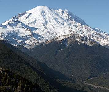
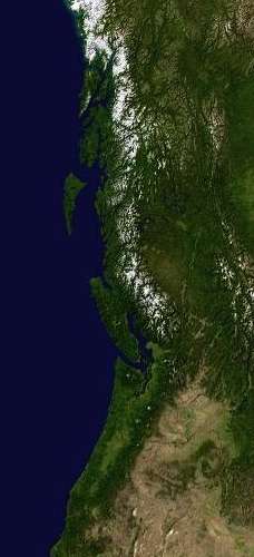
The Pacific Northwest is a diverse geographic region, dominated by several mountain ranges, including the Coast Mountains, the Cascade Range, the Olympic Mountains, the Columbia Mountains, and the Rocky Mountains. The highest peak in the Pacific Northwest is Mount Rainier, in the Washington Cascades, at 14,410 feet (4,392 m). Immediately inland from the Cascade Range, there is a broad plateau, narrowing progressively northward, only a few miles wide in Canada, and also getting higher. In the US, this region, semi-arid and often completely arid, is known as the Columbia Plateau, while in British Columbia it is the Interior Plateau, also called the Fraser Plateau. The Columbia Plateau was the scene of massive ice-age floods, and as a consequence, there are many coulees, canyons, and plateaus. Much of the plateau, especially in eastern Washington, is irrigated farmland. The Columbia River cuts a deep and wide gorge around the rim of the Columbia Plateau and through the Cascade Range on its way to the Pacific Ocean. After the Mississippi River, more water flows through the Columbia than any other river in the lower 48 states.
Because many areas have plentiful rainfall and mild summers, the Pacific Northwest has some of North America's most lush and extensive forests, which are extensively populated with Coast Douglas fir trees, the second tallest growing evergreen conifer on earth. The region also contains specimens of the tallest trees on earth, the coast redwoods, in southwestern Oregon, but the largest of these trees are located just south of the California border in northwestern California. Coastal forests in some areas are classified as temperate rain forest.
Coastal features are defined by the interaction with the Pacific and the North American continent. The coastline of the Pacific Northwest is dotted by numerous gulches, bays, mouths of rivers, coastal plains, and mountains or rocky features that seem to reach directly out of the sea. The Oregon Coast, Burrard Inlet, Puget Sound, the mouth of the Columbia River, Coos Bay, and Humboldt Bay are some of the larger features along the hundreds of miles of coast that has been shaped and reshaped by weather and geologic forces.
The major cities of Vancouver, Portland, Seattle, and Tacoma all began as seaports supporting the logging, mining, and farming industries of the region but have developed into major technological and industrial centers (such as the Silicon Forest), which benefit from their location on the Pacific Rim.
If defined as Oregon, Washington, and British Columbia, the Pacific Northwest has four US National Parks: Crater Lake in Oregon, plus Olympic, Mount Rainier, and North Cascades in Washington. If the Cascadia regional definition is used, then Redwood National and State Parks, beginning just south of the Oregon border, but located in California, is also included. Glacier Bay National Park is located in southeast Alaska, as is Wrangell–St. Elias National Park. Other outstanding natural features include the Oregon Coast, the Columbia River Gorge, the Columbia River, Mount St. Helens, and Hells Canyon. There are several Canadian National Parks in the Pacific Northwest, including Pacific Rim National Park on the west coast of Vancouver Island, Mount Revelstoke National Park and Glacier National Park in the Selkirk Range alongside Rogers Pass, Kootenay National Park and Yoho National Park on the British Columbia flank of the Rockies, Gwaii Haanas National Park Reserve in the Queen Charlotte Islands, and the Gulf Islands National Park Reserve in the Strait of Georgia. Although unprotected by national parks and only a handful of provincial parks, the south-central Coast Mountains in British Columbia contain the five largest mid-latitude icefields in the world.
Climate
The Pacific Northwest experiences a wide variety of climates. An oceanic climate ("marine west coast climate") occurs in most coastal areas, typically between the ocean and high mountain ranges. An Alpine climate dominates in the high mountains. Semi-arid and arid climates are found east of the higher mountains, especially in rainshadow areas. The Harney Basin of Oregon is an example of arid climate in the Pacific Northwest. Humid continental climates occur inland on windward sides, in places such as Revelstoke, British Columbia. A subarctic climate can be found farther north, especially in Yukon and Alaska.
Under the Köppen climate classification, a cool-summer version of the dry-summer subtropical (Csb) designation, typically referred to as "Mediterranean", is assigned to many areas of the Pacific Northwest as far north as southern Vancouver Island and the Gulf Islands, including cities such as Victoria, British Columbia, Seattle, and Portland.[29] These zones are not associated with a typical Mediterranean climate, and would be classified as Temperate Oceanic (Cfb), except dry-summer patterns typical to the Pacific Northwest meet Koeppen's minimum Cs thresholds. Other climate classification systems, such as Trewartha, place these areas firmly in the Oceanic zone (Do).[30]
Ecoregions
Much of the Pacific Northwest is forested. The Georgia Strait–Puget Sound basin is shared between British Columbia and Washington, and the Pacific temperate rain forests ecoregion, which is the largest of the world's temperate rain forest ecozones in the system created by the World Wildlife Fund, stretches along the coast from Alaska to California. The dryland area inland from the Cascade Range and Coast Mountains is very different from the terrain and climate of the coastal area due to the rain shadow effect of the mountains, and comprises the Columbia, Fraser and Thompson Plateaus and mountain ranges contained within them. The interior regions' climates largely within eastern Washington, south central British Columbia, eastern Oregon, and southern Idaho are a northward extension of the Great Basin Desert, which spans the Great Basin farther south, although by their northern and eastern reaches, dryland and desert areas verge at the end of the Cascades' and Coast Mountains' rain shadows with the boreal forest and various alpine flora regimes characteristic of eastern British Columbia, northern Idaho and western Montana roughly along a longitudinal line defined by the Idaho border with Washington and Oregon.
Population
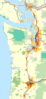
Most of the population of the Pacific Northwest is concentrated in the Portland–Seattle–Vancouver corridor. This area is sometimes seen as a megacity (also known as a conurbation, an agglomeration, or a megalopolis). This "megacity" stretches along Interstate 5 in the states of Oregon and Washington and Hwy 99 in the province of British Columbia. As of 2004, the combined populations of the Lower Mainland region (which includes Greater Vancouver), the Seattle metropolitan area and the Portland metropolitan area totaled around eight million people. However, beyond the megacity with few exceptions, the PNW region is characterized by a relatively low density population distribution. Some other regions of greater population density outside this corridor include the Okanagan Valley in the British Columbia interior (about 350,000 people centered around the city of Kelowna, which has close to 200,000 people) and the greater Spokane area (close to half a million). Large geographical areas may only have one mid-sized to small sized city as a regional center (often a county seat) with smaller cities and towns scattered around. Vast areas of the region may have little or no population at all, largely due to the presence of extensive mountains and forests, and plateaus containing both extensive farm and range lands, much of which is protected from development in large parks and preserves, or by zoning use regulation related to traditional land use. For example, all cities within the portion of California included in the Pacific Northwest have populations less than 100,000, with that portion of the state containing millions of acres of national forests and parks.
List of largest cities by population in the Pacific Northwest
Politics
A major divide in political opinion separates the region's greatly more populated urban core and rural areas west of the mountains from its less populated rural areas to their east and (in British Columbia and Alaska) north.[56] The coastal areas—especially in the cities of Vancouver, Victoria, Bellingham, Seattle, Tacoma, Olympia, Portland, Corvallis, Eugene, and Ashland—are some of the most politically liberal parts of North America, regularly supporting left-wing political candidates and causes by significant majorities, while the Interior and North tend to be more conservative and consistently support right-wing candidates and causes. It should be noted that the religious right has far less influence throughout the region than elsewhere in the U.S., and also that certain areas of the BC Interior, particularly the West Kootenay and some areas of Vancouver Island and the BC Coast, have long histories of labour, environmental and social activism (see History of British Columbia#Rise of the labour movement).
The urban core in addition to certain rural districts is known for supporting liberal political views, perceived as controversial in much of the rest of North America. Many jurisdictions have relatively liberal abortion laws, gender equality laws, legal cannabis, and strong LGBT rights, especially British Columbia, where gay marriage has been legal since 2003, Washington, where it has been legal since 2012, and Oregon, where same-sex marriage was made legal in May 2014. Due to the urban core's size and voting impact, their counties and states as a whole have generally followed their leads, often to the disgruntlement of the more conservative rural areas. Oregon was the first U.S. state to legalize physician-assisted suicide, with the Death with Dignity Act of 1994. Washington State was the second when I-1000 passed in 2008. Colegio Cesar Chavez, the first fully accredited Hispanic college in the U.S., was founded in Mount Angel, Oregon in 1973. In 1986 King County, Washington, which contains Seattle, renamed itself in honor of Martin Luther King.
These areas, especially around Puget Sound, have a long history of political radicalism. The radical labor organizers called Wobblies were particularly strong there in the mines, lumber camps and shipyards. A number of anarchist communes sprung up there in the early 20th century (see Charles Pierce LeWarne's Utopias on Puget Sound, 1885-1915 for an overview of this popular yet forgotten movement). Seattle is one of a handful of major cities in North America in which the populace engaged in a general strike (in 1919) and was the first major American city to elect a woman mayor, Bertha Knight Landes (in 1926).[57] Socialist beliefs were once widespread (thanks in large part to the area's large numbers of Scandinavian immigrants) and the region has had a number of Socialist elected officials. So great was its influence that the U.S. Postmaster General, James Farley, jokingly toasted the "forty-seven states of the Union, and the Soviet of Washington", at a gala dinner in 1936 (although Farley denied ever saying it).[58]
The region also has a long history of starting cooperative and communal businesses and organizations, including Group Health,[59] REI, Puget Consumer's Co-ops and numerous granges and mutual aid societies. It also has a long history of publicly owned power and utilities, with many of the region's cities owning their own public utilities. In part as a result, the region enjoys the lowest electrical power rates on the continent. In British Columbia, credit unions are common and popular cooperatively owned financial institutions.
East of the Cascades, in eastern Washington, eastern Oregon, and Idaho, the population is much more conservative. The eastern portions of Washington and especially Oregon, due to their low populations, do not generally have enough voting power to be competitive at the state level, and thus the governorships and U.S. Senate seats of both Oregon and Washington are usually held by the Democrats. Idaho, being a separate state located entirely within the conservative interior of the Pacific Northwest, is a Republican stronghold. Conservatism in the eastern part of the Pacific Northwest tends to be distrustful of federal government interference and strongly protective of gun rights.
Economy
- Agriculture (fruit, potatoes, Tillamook cheese, dairy, wine, vegetables, wheat, Cascade hops, barley, hazelnuts)
- Aerospace (Boeing Commercial Airplane unit, Air Canada, Alaska Air, CHC Helicopter, Esterline, Glasair Aviation)
- Diversified (Jim Pattison Group, Finning, Washington Marine Group)
- Entertainment industry (film and television, Lions Gate Entertainment, Lionsgate Studios, Lionsgate Television, Vancouver Film Studios, Bridge Studios)
- Finance and banking (RBC, HSBC Bank Canada, Russell Investments, Umpqua Holdings Corporation)
- Forestry (Weyerhaeuser, Canfor, Tolko, Boise Cascade, The Teal-Jones Group, Humboldt and Mendocino Redwood Companies, Green Diamond Resource Company)
- Fishing and canning (salmon, halibut, herring, geoducks and other clams, crab, sea-urchin, oyster)
- High Technology and E-commerce (Microsoft, Microsoft Canada, Intel, F5 Networks, Nintendo of America, Nintendo of Canada, Tektronix, Amazon.com, Expedia, Ballard Power Systems, MacDonald Dettwiler, EA Canada, Cymax Stores, Micron Technology, Electronic Arts, Ballard Technologies)
- Hydroelectric power (Grand Coulee Dam, Bonneville Dam, BC Hydro)
- Mass Retail (London Drugs, Costco, Blenz, Starbucks, Tullys, Nordstrom, Zumiez, Albertsons)
- Microbrewing (BridgePort, Deschutes, Lost Coast Brewery, MacTarnahan's, Nelson, Ninkasi, Pyramid, Widmer Brothers, Yukon)
- Mining (Goldcorp, Cominco)
- Outdoor Tourism (alpine skiing, snowboarding, hiking, kayaking, rafting, fishing, mountain biking, water sports)
- Shoes & Apparel (Nike, Adidas North America, Columbia, R.E.I., Lululemon, Eddie Bauer, Mountain Equipment Co-op)
- Real estate marketing & realty development/construction.
Aluminum smelting was once an important part of the region's economy due to the abundance of once-cheap hydroelectric power. Hydroelectric power generated by the hydroelectric dams on the Columbia River powered at least ten aluminum smelters during the mid-20th century. By the end of World War II these smelters were producing over a third of the United States' aluminum. Production rose during the 1950s and 1960s, then declined. By the first decade of the 21st century the aluminum industry in the Pacific Northwest was essentially defunct.[60] The Alcan smelter at Kitimat continues in operation and is fed by the diversion of the Nechako River (a tributary of the Fraser) to a powerhouse on the coast at Kemano, near Kitimat.
The region as a whole, but especially several specific areas are concentrated high-tech areas: Seattle eastern suburbs, the Portland Silicon Forest area, and Vancouver, BC. These areas are also leading "creative class" economic drivers, feeding thriving cultural sectors, and include many knowledge workers and numerous international advertising, media and design firms present.
Education
Colleges and universities in the Pacific Northwest:
- British Columbia
- California (Northwestern area only, which is part of Cascadia)
- College of the Redwoods - a public two-year community college, main campus located in Eureka, California.
- College of the Siskiyous - a public two-year community college, located in Weed and Yreka, California.
- Humboldt State University - a California State University (public), located in Arcata, California.
- Idaho
- Montana
- Oregon
- Washington
Culture
Although the dominant culture in the Pacific Northwest today is Anglo-American and Anglo-Canadian, there is significant Mexican and Chinese influence. 23% of Vancouver, B.C. is Chinese, and 50% of residents of the City of Vancouver do not speak English as their first language.[61] Parts of Oregon and Washington are bilingual in both English and Spanish, and Native American culture is strong throughout the Pacific Northwest. The hippie movement also began in California and the Pacific Northwest. There have been proposals for certain parts of the Pacific Northwest becoming its own country because of the shared ecoregion and culture,[62][63] the most well-known being Cascadia. However, the region is strongly divided by the international border, and this division has grown more rather than less powerful over the 20th century.[64] Carl Abbott argues that, given the twin factors of limited economic integration vis-a-vis NAFTA, and cultural similarities, he views the major cities as "going their separate ways" as east-west gateways of commerce, competing with each other, rather than forming north-south connectors of a tentative "megaregion.[64] "
Cannabis use is relatively popular, especially around Vancouver, B.C., Bellingham, Seattle, Olympia, Spokane, Portland and Eugene. Several of these jurisdictions have made arrests for cannabis a low enforcement priority. Medical marijuana is legal in British Columbia,[65] Washington[66] and Oregon,[67] as well as in Alaska, though that state prohibits its sale and has no licensed dispensaries,[68] and in the Yukon, although less than 50 of the territory's residents are licensed to use medical marijuana and no legal dispensaries operate within its borders.[69] As of December 6, 2012, possession of less than an ounce of marijuana for recreational use by persons over 21 years of age became legal in Washington state as a result of state ballot measure Initiative 502, which was approved by the state's voters on November 6, 2012, by a ten-point margin. As of July 1, 2015, recreational marijuana use was legalized in Oregon as well.[70][71]
Environmentalism
Environmentalism is prominent throughout the region, especially west of the Cascades. Environmentally conscious services such as recycling and public transportation are widespread, most notably in the more populous areas. A 2007 statistical analysis ranked the 50 Greenest Cities in the United States, placing Portland, Oregon first, Eugene, Oregon fifth, and Seattle, Washington eighth.[72] The region as a whole is also known for its bicycle culture as an alternative form of transportation; Portland is considered by Forbes Traveler to be the second most bicycle-friendly city in the world.[73] Portland is also the hub of American bicycle manufacturing; as a whole it generated over $68 million in revenue in 2007 alone.[73] Seattle, Washington has also garnered a reputation for its contributions to public transportation with the Puget Sound Transit system, including an underground light rail system and a 38.9% worker commute rate as of 2011.[74] Politically, the Pacific Northwest is actively involved in environmental efforts. The international organization Greenpeace was born in Vancouver in 1970 as part of a large public opposition movement in British Columbia to US nuclear weapons testing on Amchitka Island in the Aleutians. Liberal and Conservative Northwesterners, such as former U.S. Senator Slade Gorton (R-WA) and moderate Democrats like former Speaker of the House Tom Foley (D-WA), have been prominent in the development of conservative approaches to environmental protection. Seattle in particular is also home to a large number of publications and institutions concerned with the environment and sustainability, including both Worldchanging and Grist.org, the U.S.'s two largest online green magazines. The Pacific Northwest is also noted for a large number of gardening clubs, with Victoria having an annual flower count in February.
The direct-intervention oceanic protection group known as the Sea Shepherd Conservation Society has its headquarters in Friday Harbor on San Juan Island.[75]
Music
The modern-era Pacific Northwest is known for indie music, especially grunge, alternative rock, and metal as well as historically-strong folk music and world music traditions. Many are associated with the independent label Sub Pop. Lately the region has also gained notice for its Hip hop music in the Pacific Northwest. KEXP.org is a popular and nationally-noted Seattle-based public indie music radio station. Among the area's largest music festivals are the Merritt Mountain Music Festival, the Vancouver Folk Music Festival, the Sasquatch! Music Festival in George, Washington, Seattle's Bumbershoot, and Portland's MusicfestNW. Portland's Waterfront Blues Festival is the largest blues-based festival west of the Mississippi River.
Local artists who became ground-breaking rock bands of their times include Jimi Hendrix, Nirvana, Pearl Jam, Soundgarden, Alice in Chains, Foo Fighters and The Presidents of the United States of America, But the history of Northwest rock can be traced back to the mid 1950s and 1960s with such bands such as The Sonics, The Ventures, The Kingsmen, and Paul Revere and the Raiders.[76]
Cuisine
Cuisine of the area include wild salmon, huckleberries, a wide variety of Asian cuisines, and locally produced fruits, vegetables, and cheeses.
Chinese, Japanese, Korean, Italian, Mexican, and Greek cuisines are prevalent throughout the Northwest, and reflect the historically strong presence of those communities in the restaurant industry there. Teriyaki restaurants are particularly common in the Seattle area.[77][78] Eateries featuring Persian, Asian Fusion, and Indo-Canadian cuisines are common throughout in Greater Vancouver, as are ethnic specialty restaurants of all kinds. Ethnic staples ranging from frozen perogies to frozen dim sum are common in most supermarkets in these communities.
Locally-made craft beers and premium wines from various wine-growing area within the region are popular with drinkers and diners. Northern latitude and coastal breezes create a climate that attracts international recognition for its mostly family-owned and operated vineyards and wineries.
Portland is a major microbrewery center in America,[79] and is home to the Widmer Brothers Brewery.
Sports
Skiing, snowboarding, cycling, mountaineering, hiking, camping, hunting, fishing, boating, and water sports are popular outdoor activities. Vancouver, Seattle, Tacoma, Portland, and Spokane are home to numerous professional sports teams, including the BC Lions, Vancouver Canucks, Vancouver Canadians, Vancouver Whitecaps FC, Vancouver Stealth, Seattle Mariners, Seattle Seahawks, Seattle Sounders FC, Seattle Rainmakers, Seattle Storm, Everett Aquasox, Tacoma Rainiers, Portland Trail Blazers, Portland Timbers, Hillsboro Hops, Salem-Keizer Volcanoes, Eugene Emeralds, Spokane Empire, and Spokane Indians.
The region's three USSF Division 1 Major League Soccer teams the Whitecaps FC, Sounders FC, and Timbers play to sold out crowds and compete annually for the Cascadia Cup. The USSF Division 4 USL Premier Development League also has seven teams in the Northwest Division. In addition to all this the region has its own representative non-FIFA team which joined the N.F.-Board officially in 2013 to participate in friendlies and the VIVA World Cup.
Vancouver is home to a 4-team league for Australian football, the British Columbia Australian Football League, one of several Canadian Australian football leagues.
Hockey is the most popular spectator sport in British Columbia, with the Vancouver Canucks of the NHL being the most popular professional team, although the Vancouver Giants of the Western Hockey League also have a very strong following. The CFL's BC Lions are considered Vancouver's second most popular team, although soccer and the Whitecaps FC have been rising in popularity in recent years. Hockey is slowly gaining popularity south of the border too, with the Portland Winterhawks.
Followers of the Portland Trail Blazers basketball team refer to themselves as the Sixth Man and Blazermania refers to the extraordinary dedication fans have shown the team. In Seattle many fans are still upset over the move of the Seattle SuperSonics while supporters of the Seattle Seahawks football team are known officially as the 12th Man.[80] And the supporter groups, (namely the Emerald City Supporters, Timbers Army, and Vancouver Southsiders) of the three MLS teams of the region are renowned for their passion and dedication to their teams.
The only NASCAR track in the Seattle / Portland region is Evergreen Speedway, the largest short track west of the Mississippi River and has hosted many of the marquee drivers of NASCAR. With three oval tracks, a figure eight track and various road course variants, Evergreen Speedway operates year-round events. Evergreen Speedway hosts the NASCAR Whelen All American Series, the NASCAR K&N Pro Series West, National Figure Eight Events, USAC, SCCA, plus Touring Groups and Formula Drift.
In Washington and Oregon, many residents passionately follow college athletics. In Washington, the major NCAA Division I college athletic programs are the University of Washington Huskies and the Washington State Cougars. In Oregon the major programs are the University of Oregon Ducks and the Oregon State Beavers. All four of these programs are members of the Pac-12 Conference and compete with each other in a variety of sports. These universities are all considered rivals of one another, particularly in college football. The most significant of these rivalries are the Oregon – Washington game, the Washington-Washington State game, a.k.a. the Apple Cup (named so because of Washington's notoriety for apple production) and the Oregon-Oregon State game a.k.a. the Civil War. As in professional sports, college fans in the Pacific Northwest are known for being particularly passionate about their teams. Both Husky Stadium (where the Washington Huskies play football) and Autzen Stadium (where the Oregon Ducks play football) have gained reputations for deafening noise, despite not being the largest of college football venues. Husky Stadium currently holds the record for the loudest crowd noise in NCAA history at 130 decibels,[81] while Autzen Stadium currently holds the record for the 4th at 127 decibels.[82]
Video games
Seattle is considered by Digital Trends magazine to be the top gaming city in America, a possible indicator of markedly higher rates of video game usage throughout the Pacific Northwest in general.[83] Major companies headquartered in the region include Microsoft (Seattle Metropolitan Area), Microsoft Canada (Vancouver), Nintendo of America (Seattle Metropolitan Area), Nintendo of Canada (Vancouver), and video games maker Electronic Arts (Vancouver), as well as Valve Corporation, Bungie, and Sony subsidiary Sucker Punch Productions, all three are located in the Seattle Metropolitan Area.
Demographics
In the U.S. side of the region, Latinos make up a large portion of the agricultural labor force east of the Cascade Range, and are an increasing presence in the general labor force west of the Cascades. African Americans are less numerous in the Pacific Northwest; however, the overall African American population has been growing in other smaller urban areas throughout the region, such as Spokane and Eugene.[84] African Americans tend to concentrate in western urban areas such as Tacoma, south Seattle, and Portland. Nonetheless, blacks have a very large presence in Tacoma's Hilltop and South Tacoma neighborhoods, Seattle's Central District and Rainier Valley neighborhoods,[85] and in Portland's Northeast Quadrant.[86] There are growing numbers in Vancouver as well, particularly Africans, Jamaicans and blacks from the United States. As of the first decade of the 21st century, many Asians were moving out and into middle class suburbs, though some would voice concern about preserving historical communities particularly in Vancouver. British Columbia has the largest Asian presence per-capita in North America, with 10% of the population being of Chinese ancestry and also large numbers of South Asians, Filipinos, and others. The Asian presence in the U.S. section of the Pacific Northwest is comparably smaller, with all Asian groups together comprising about 8% of Washington state's population, and smaller figures in Oregon and Idaho. This is due to immigration quotas at the federal level, as while Canada has one-tenth the population of the United States, it takes in one-quarter as many immigrants.
African-Americans have held the positions of Mayor in Seattle and Spokane; King County executive, while the state of Washington elected a Chinese American governor during the 1990s, Gary Locke.
British Columbians of many ethnicities are prominent in all levels of politics and government, and the province has a number of "firsts" in Canadian political history, including the first non-white Premier, Ujjal Dosanjh (who is Indo-Canadian) and the first Asian Lieutenant-Governor, the Hon. David Lam. The Lieutenant-Governor from 2007 to 2012, Steven Point, was of aboriginal origin, being Stó:lō (the dominant type of Coast Salish in BC's Lower Mainland) from the Chilliwack area. The leader of the opposition party from 2005 to 2011, the NDP, was Carole James, of partial Métis origin. Colonial governor James Douglas was himself mulatto of Guyanese extraction and his wife was of Cree origin.
On LGBT representation in government, Oregon has been a national leader. At the time of his election to the office of Portland mayor in 2008, Sam Adams was the first openly gay individual to represent a city of Portland's size in the United States. In Silverton, Oregon, the same year, Stu Rasmussen was elected the first transgender mayor in U.S. history. The first two LGBT state supreme court justices in the country both sit on the Oregon Supreme Court. Governor of Oregon Kate Brown is the highest-ranking openly bisexual politician in the United States.
Language
Most Americans and Canadians consider the Pacific Northwest English accent "neutral," though indistinct from the Midwestern dialects that some believe typify American speech. It possess the low back vowel merger, or the cot–caught merger. Canadian raising occurs in British Columbia and some speakers in Washington to a similar degree as it does in southern Ontario, but weaker than other parts of Canada. The California Vowel Shift also affects speech in the region.
Chinook Jargon was a pidgin or trade language established among indigenous inhabitants of the region. After contact with Europeans, French, English, and Cree words entered the language, and "eventually Chinook became the lingua franca for as many as 250,000 people along the Pacific Slope from Alaska to Oregon."[87] Chinook Jargon reached its height of usage in the 19th century though remained common in resource and wilderness areas, particularly but not exclusively by Native Americans and Canadian First Nations people, well into the 20th century. Today its influence is felt mostly in place names and a handful of localized slang terms, particularly the word skookum, which remains hallmark of people raised in the region.
Besides English and indigenous languages, Chinese has been common since the gold rushes of the mid-19th century, most particularly in British Columbia. Since the 1980s the Toishan, a Yue dialect predominant in the area, has been replaced by mainstream Cantonese and by Mandarin because of large-scale immigration from Asia. Punjabi is also common in Vancouver, which has very large Sikh communities. Spanish is also spoken in parts of Oregon and Washington by Mexicans, both recent immigrants and long-standing communities.
National Self-determination Desires
Among the fiercely independent and frontier nature of the former Oregon Country and now Western Part of the United States, are a desire of many Pacific Northwesterners to improve upon their form of Democracy by further subdividing the region into socio-political or bioregion defined nation states. Some desires are trasnational and autonomous of the United States while others are in the hope of gaining additional representational control in particular regions of the Northwest. Among these fluidly changing geographical boundaries and areas sought by a segment of the population of the Northwest are the following:
- Pacific Northwest Independence and Secessionist Movements
Spirituality and religion
The Pacific Northwest has the lowest rate of church attendance in the United States and consistently reports the highest percentage of atheism;[88][89] this is most pronounced on the part of the region west of the Cascades.[90] A recent study indicates that one quarter of those in Washington and Oregon believe in no religion.[91] Similarly, according to the 2011 National Household Survey, 44% of British Columbia residents reported no religion.[92]
Religion plays a smaller part in Pacific Northwest politics than in the rest of the United States. The religious right has considerably less political influence than in other regions. Political conservatives in the Pacific Northwest tend to identify more strongly with free-market libertarian values than they do with more religious social conservatives.[93]
That said, three of the four major international charities in the region are religious in nature: Northwest Medical Teams International, World Concern, World Vision International, and Mercy Corps. This is part of a long tradition of activist religion. The Skid Road Group, a shelter offering soup and sermons to the unemployed and recovering alcoholics, was launched in Vancouver, with the Salvation Army having deep roots in the Gastown district, dating back to the era of the construction of the Canadian Pacific Railway (1880s) and attained prominence in the same centers during the Klondike Gold Rush.
The region is also known as a magnet for a wide range of philosophical and spiritual belief systems. Eastern spiritual beliefs have been adopted by an unusually large number of people (by North American standards), and Tibetan Buddhism in particular has a strong local following.[94] The Northwest Tibetan Cultural Association, claimed to be the largest organization of its kind in the world, was founded in Portland in 1993.
The region is home to many unique Christian communities, ranging from the Doukhobors to the Mennonites. The Mennonite Central Committee Supportive Care Services is based in Abbotsford, BC.[95] The Mennonite Central Committee and the Mennonite Disaster Service enjoy a heavy rate of enlistment and donations from the strong Mennonite community in British Columbia's Fraser Valley. The Doukhobors, whose church is the Union of Spiritual Communities of Christ, are a Russian anabaptist sect whose migration to Canada was aided by Count Leo Tolstoy and who are today focussed in the West Kootenay and Boundary regions of Southeastern British Columbia. their history in Canada includes resistance to state education and industrial development (see Sons of Freedom). Also, within the region there is a fairly strong representation of Orthodox churches (Greek, Russian, Serbian and others), as well as the Ukrainian Greek Catholic Church. Religious sees that are based in the Pacific Northwest include the Roman Catholic ecclesiastical provinces of Portland, Seattle, and Vancouver, Province 8 of the Episcopal Church in the United States of America, the Anglican Ecclesiastical Province of British Columbia and the Yukon, and the suffragan dioceses that make up those provinces.
Yogic teachings, Sufism, tribal and ancient beliefs and other philosophies are widely studied and appreciated in the region. The Lower Mainland of British Columbia has a very large Sikh community. Oregon has a considerable Quaker (Society of Friends) population. There has been major growth in Chinese Buddhist temples since the increase in immigration from East Asia in the 1980s, especially in Vancouver.
Also in Vancouver, there is a small Hindu population, a number of Parsee (Zoroastrians), and an emerging Muslim population from South Asia, the Middle East, Africa, the Balkans, Southeast Asia and elsewhere.
Some people in the area also embrace alternative religion, such as New Age spirituality and Neo-Paganism.[96] A New Thought church called Living Enrichment Center with 4,000 members was located in Wilsonville, Oregon from 1992 to 2004.[97]
- Brother Twelve ran a controversial commune in the Gulf Islands of British Columbia early in the 20th century
- The Emissaries of Divine Light are a notable presence in the region of 100 Mile House, British Columbia and also have a large ashram on Kootenay Lake, northeast of Nelson, British Columbia
- Gangaji, an internationally recognized spiritual teacher and disciple of Poonjaji, lives in Ashland, Oregon
- The followers of the Guru Rajneesh, the sannyasins, established a center for their beliefs and lifestyle near Antelope, Oregon, which included an ashram complex as well as, for a while, an attempted takeover of the local economy
- The training school of the immortal (according to the organization) being Ramtha is headquartered in Yelm, Washington
- Eckhart Tolle, author of The Power Of Now, lives in Vancouver, British Columbia
- Neale Donald Walsch, author of Conversations with God, lives in Ashland, Oregon, where he runs a retreat center
- Oregon's Willamette Valley has a large population of Russian Old Believers[98]
See also
- Atlantic Northeast, another region shared between Canada and the U.S.
- Cascadia (disambiguation)
- Climate change in Washington
- Megaregions of the United States
- Northwest Coast art
- Cascadia (independence movement)
- List of Cascade Range topics
Notes and references
- Notes
- 1 2 3 4 5 6 7 8 Part of Greater Vancouver.
- 1 2 3 4 5 Part of Seattle metropolitan area (Seattle-Tacoma-Bellevue, WA MSA).
- 1 2 3 4 Part of Portland metropolitan area (Portland-Vancouver-Hillsboro, OR-WA MSA).
- ↑ Part of Greater Victoria.
- 1 2 Part of Boise metropolitan area (Boise City–Nampa, Idaho Metropolitan Statistical Area (MSA)).
- References
- ↑ "Interior Savings Centre in Kamloops, British Columbia". Interiorsavingscentre.com. Retrieved 2010-08-18.
- ↑ "Best Places to Live in Seattle-Tacoma-Bellevue, Washington Metro Area (WA)". Bestplaces.net. Retrieved 2010-08-18.
- ↑ "Statistics Canada: Population of census metropolitan areas".
- ↑ "Doing Business In Portland, Oregon". Business.GOV.
- 1 2 3 4 5 Coates, Ken S. (2002). "1. Border Crossings". In Findlay, John M.; Coates, Ken S. Parallel Destinies: Canadian-American Relations West of the Rockies. University of Washington Press. pp. 3–5. ISBN 978-0-295-98252-6. Retrieved 14 December 2010.
- 1 2 "Map of Cascadia". Sightline.org. Retrieved 2011-02-19.
- ↑ Schwantes, Carlos A. (1 January 1996). The Pacific Northwest: an interpretive history. University of Nebraska Press. pp. 1–2. ISBN 978-0-8032-9228-4. Retrieved 14 December 2010.
- ↑ Richards, Kent D. (November 1981), "In Search of the Pacific Northwest: The Historiography of Oregon and Washington", Pacific Historical Review, University of California Press, 50 (4): 415–443, JSTOR 3639158
- 1 2 Hayes, Derek (1999). Historical atlas of the Pacific Northwest: maps of exploration and discovery : British Columbia, Washington, Oregon, Alaska, Yukon. Sasquatch Books. ISBN 978-1-57061-215-2. Retrieved 12 July 2011.
- ↑ See, for example, this US EPA map Archived July 27, 2011, at the Wayback Machine..
- ↑ Apostol, Dean; Sinclair, Marcia; Society for Ecological Restoration International (2006). Restoring the Pacific Northwest: the art and science of ecological restoration in Cascadia. Island Press. p. 24. ISBN 978-1-55963-078-8. Retrieved 14 December 2010.
- ↑ "Ancient site of human activity found on Oregon coast". Oregon State University. 6 November 2002.
- ↑ Loren G. Davis (2008), "New Support for a Late-Pleistocene Coastal Occupation at the Indian Sands Site, Oregon" (PDF), Archaeology: North America, 25, pp. 74–76
- ↑ Diamond, Jared (1999). Guns, Germs, and Steel: The Fates of Human Societies. W. W. Norton. p. 90. ISBN 978-0-393-06922-8. Retrieved 14 May 2013.
- 1 2 Pauketat, Timothy (2012). The Oxford Handbook of North American Archaeology. Oxford University Press. pp. 160–162, 167. ISBN 978-0-19-538011-8. Retrieved 14 May 2013.
- ↑ Harris, Marvin (2001). Cultural Materialism: The Struggle for a Science of Culture. Rowman Altamira. p. 85. ISBN 978-0-7591-0135-7. Retrieved 14 May 2013.
- ↑ Pauketat, Timothy (2012). The Oxford Handbook of North American Archaeology. Oxford University Press. pp. 173–175. ISBN 978-0-19-538011-8. Retrieved 14 May 2013.
- ↑ Nash, Gary B. Red, White and Black. Pearson. Los Angeles 2015. Chapter 1, pg. 5
- ↑ Quanchi, Max; Robson, John (2005). Historical dictionary of the discovery and exploration of the Pacific islands. Scarecrow Press. pp. 84–85, 207. ISBN 978-0-8108-5395-9. Retrieved 12 July 2011.
- ↑ Hayes, Derek (1999). Historical atlas of the Pacific Northwest: maps of exploration and discovery : British Columbia, Washington, Oregon, Alaska, Yukon. Sasquatch Books. p. 16. ISBN 978-1-57061-215-2. Retrieved 12 July 2011.
- ↑ "Vitus Bering Biography Summary". BookRags.com. Retrieved 2010-08-18.
- 1 2 "Historical Timeline". Ubcic.bc.ca. 2007-09-13. Retrieved 2010-08-18.
- 1 2 3 Hayes, Derek (1999). Historical Atlas of the Pacific Northwest: Maps of exploration and Discovery. Sasquatch Books. ISBN 1-57061-215-3.
- ↑ "Captain Alexandro Malaspina". Malaspina University-College. Retrieved 2008-02-05.
- ↑ Boyer, Paul S. The Enduring Vision: A History of the American People. (Lexington MA 1996), p. 6
- ↑ "Fifty-Four Forty or Fight". Geography.about.com. 2010-06-14. Retrieved 2010-08-18.
- ↑ "The Alaska Boundary Dispute" (PDF). Archived from the original (PDF) on 2008-12-18. Retrieved 2010-08-18.
- ↑ "Volcano Seismicity in the Pacific Northwest". Pnsn.org. Retrieved 2010-08-18.
- ↑ "HESS - Abstract - Updated world map of the Köppen-Geiger climate classification". Hydrol-earth-syst-sci.net. 2010-07-04. Retrieved 2010-08-18.
- ↑ "Global Ecological Zoning for the Global Forest Resources Assessment 2000". Fao.org. Retrieved 2010-08-18.
- 1 2 3 4 5 6 7 8 9 "U.S. Census Bureau Delivers Washington's 2010 Census Population Totals". United States Census Bureau. February 23, 2011. Retrieved 11 July 2011.
- 1 2 3 4 5 6 "Population and Housing Occupancy Status: 2010 - United States -- Metropolitan Statistical Area; and for Puerto Rico". 2010 United States Census. United States Census Bureau, Population Division. April 14, 2011. Retrieved 12 July 2011.
- 1 2 "Census Profile - Census Subdivision". 2.statcan.ca. 2012-02-01. Retrieved 2012-03-01.
- ↑ "Census Profile - Census Subdivision". 2.statcan.ca. 2012-02-01. Retrieved 2012-03-01.
- ↑ "Census Profile - Census Subdivision". 2.statcan.ca. 2012-02-01. Retrieved 2012-03-01.
- ↑ "Washington population by county - Census 2010: Washington". The Spokesman-Review. Retrieved 12 July 2011.
- 1 2 "U.S. Census Bureau Delivers Idaho's 2010 Census Population Totals". United States Census Bureau. February 23, 2011. Retrieved 11 July 2011.
- ↑ "Census Profile - Census Subdivision". 2.statcan.ca. 2012-02-01. Retrieved 2012-03-01.
- 1 2 3 4 5 "U.S. Census Bureau Delivers Oregon's 2010 Census Population Totals". United States Census Bureau. February 23, 2011. Retrieved 31 December 2012.
- 1 2 "Census Profile - Census Subdivision". 2.statcan.ca. 2012-02-01. Retrieved 2012-03-01.
- ↑ "Census Profile - Census Subdivision". 2.statcan.ca. 2012-02-01. Retrieved 2012-03-01.
- 1 2 "Census Profile - Census Subdivision". 2.statcan.ca. 2012-02-01. Retrieved 2012-03-01.
- ↑ "Census Profile - Census Subdivision". 2.statcan.ca. 2012-02-01. Retrieved 2012-03-01.
- ↑ "Census Profile - Census Subdivision". 2.statcan.ca. 2012-02-01. Retrieved 2012-03-01.
- 1 2 "Census Profile - Census Subdivision". 2.statcan.ca. 2012-02-01. Retrieved 2012-03-01.
- 1 2 "Washington population by city - Census 2010: Washington". The Spokesman-Review. Retrieved 12 July 2011.
- 1 2 "Census Profile - Census Subdivision". 2.statcan.ca. 2012-02-01. Retrieved 2012-03-01.
- ↑ "Census Profile - Census Subdivision". 2.statcan.ca. 2012-02-01. Retrieved 2012-03-01.
- ↑ "Census Profile - Census Subdivision". 2.statcan.ca. 2012-02-01. Retrieved 2012-03-01.
- ↑ "Census Profile - Census Subdivision". 2.statcan.ca. 2012-02-01. Retrieved 2012-03-01.
- ↑ "Census Profile - Census Subdivision". 2.statcan.ca. 2012-02-01. Retrieved 2012-03-01.
- 1 2 "Census Profile - Census Subdivision". 2.statcan.ca. 2012-02-01. Retrieved 2012-03-01.
- 1 2 "USA: Oregon". Citypopulation.de. 2010. Retrieved 25 June 2012.
- ↑ "Census Profile - Census Subdivision". 2.statcan.ca. 2012-02-01. Retrieved 2012-03-01.
- ↑ http://data.spokesman.com/census/2010/idaho/cities/meridian-id/
- ↑ Font size Print E-mail Share (2000-10-25). "Northwest Passage". CBS News. Retrieved 2010-08-18.
- ↑ Archived June 29, 2011, at the Wayback Machine.
- ↑ "Communism in Washington State - History and Memory Project". Depts.washington.edu. Retrieved 2011-02-19.
- ↑ "HistoryLink Essay: Group Health Cooperative - Part 1: Planting the Seeds, 1911-1945". Historylink.org. 2005-11-13. Retrieved 2011-02-19.
- ↑ Aluminum, Columbia River History, Northwest Power & Conservation Council
- ↑ Arthur Frommer (2008-12-08). "Vancouver's melting pot makes a terrific cultural stew". Chicago Tribune.
- ↑ The Republic of Cascadia Retrieved on 2009-12-23
- ↑ "Retrieved on 2009-12-23". Cascadia-bioregion.tripod.com. 1924-05-03. Retrieved 2011-02-19.
- 1 2 Abbott, Carl (2002). "8. That Long Western Border". In Findlay, John M.; Coates, Ken S. Parallel Destinies: Canadian-American Relations West of the Rockies. University of Washington Press. pp. 203–213–5. ISBN 978-0-295-98252-6. Retrieved 14 December 2010.
- ↑ Frequently Asked Questions - Medical Use of Marihuana, Health Canada
- ↑ Washington Medical Marijuana Legality, Washington State RCW
- ↑ "Oregon Medical Marijuana Legality". Oregon.gov. 2011-02-01. Retrieved 2011-02-19.
- ↑ Richardson, Jeff (22 May 2011). "Without dispensaries, Alaska has avoided federal medical marijuana prosecutions". Juneau Empire. Retrieved 14 June 2012.
- ↑ Oke, Chris (14 May 2010). "Medical marijuana, coming to a store near you". Yukon News. Retrieved 14 June 2012.
- ↑ Martin, Jonathan (November 6, 2012). "Voters agree to legalize pot". Seattle Times. Retrieved November 6, 2012.
- ↑ "November 5, 2012 General Election Results.". The state of Washington. 2012-11-05.
- ↑ Svoboda, Elizabeth (2010-08-07). "America's 50 Greenest Cities | Popular Science". Popsci.com. Retrieved 2010-08-18.
- 1 2 Bower, Craig S. (2008-06-19). "North America's most bike-friendly cities - Travel - Active Travel - msnbc.com". MSNBC. Retrieved 2010-08-18.
- ↑ "The Best Cities for Public Transportation | SmartAsset.com". smartasset.com. Retrieved 2016-05-10.
- ↑ "Anti-whaling boat owned by San Juan's Sea Shepherd Society takes on water near Antarctica". Journal of the San Juans. January 6, 2010. Retrieved September 11, 2016.
- ↑ “Louie Louie” and the History of Northwest Rock and Radio. DVD. Directed by SoundWorks USA. Rolling Bay, WA: Soundworks USA, 2012.
- ↑ Edge, John T. (January 5, 2010), "A City's Specialty, Japanese in Name Only", The New York Times
- ↑ Kauffman, Jonathan (August 14, 2007), "How Teriyaki Became Seattle's Own Fast-Food Phenomenon", Seattle Weekly
- ↑ Gross, Matt (May 10, 2009). "Frugal Portland". The New York Times. Retrieved May 20, 2010.
- ↑ "Spirit of 12". Seahawks.com. Archived from the original on February 9, 2009. Retrieved 2010-08-18.
- ↑ http://www.gohuskies.com/facilities/husky-stadium.html
- ↑ http://www.michigandaily.com/content/j-brady-mccollough-duck-duck-lose
- ↑ "Seattle Top Gaming City?". Digital Trends. May 2, 2006.
- ↑ "uwnews.washington.edu". uwnews.washington.edu. 1997-01-15. Retrieved 2011-02-19.
- ↑ Quintard Taylor, "Blacks and Asians in a white city: Japanese Americans and African Americans in Seattle, 1890-1940." Western Historical Quarterly (1991): 401-429.in JSTOR
- ↑ Quintard Taylor, "The Emergence of Black Communities in the Pacific Northwest: 1865-1910." Journal of Negro History (1979): 342-354. in JSTOR
- ↑ "Can We Still Speak Chinook?". Thetyee.ca. Retrieved 2011-02-19.
- ↑ "Religion and Public Life in the Pacific Northwest". Religionatlas.org. Retrieved 2011-02-19.
- ↑ "Charting the unchurched in America". USA Today. March 7, 2002. Retrieved May 20, 2010.
- ↑ "Religious identification in the U.S". Religioustolerance.org. Retrieved 2011-02-19.
- ↑ "American Religious Identification Survey" (PDF). March 2009.
- ↑ "National Household Survey". 2011.
- ↑ Vance, Chris (July 24, 2007). "Crosscut Seattle - Why Washington Republicans got creamed in 2006 and what they can do about it". Crosscut.com. Retrieved 2011-08-13.
- ↑ Yardley, William (April 11, 2008). "Dalai Lama Arrives for a Five-Day Conference in Seattle, Very Much His Kind of Town". The New York Times. Retrieved May 20, 2010.
- ↑ Mennonite Central Committee Supportive Care Services Archived August 19, 2006, at the Wayback Machine.
- ↑ "ABC News: School Says Halloween Disrespectful to Witches". Abcnews.go.com. 2004-10-21. Retrieved 2011-02-19.
- ↑ Janine Robben (May 19, 2004). "the Prophet margin". wweek.com. Retrieved November 22, 2012.
- ↑ Oregon Historical Society article about Old Believers. Retrieved February 9, 2007.
Further reading
- Blair, Karen J., ed. Women in Pacific Northwest History: An Anthology (2nd ed. U of Washington Press, 2014).
- Blumm, Michael C. "Environment, Economy, and Community in the Pacific Northwest." Public Land and Resources Law Review 17.1 (2013): 2+ online
- Gastil, Raymond D., and Barnett Singer. The Pacific Northwest: Growth of a Regional Identity (McFarland, 2010) 221 pp. ISBN 978-0-7864-4540-0
- Inglis, Robin. Historical Dictionary of the Discovery and Exploration of the Northwest Coast of America (Scarecrow, 2008) lxxvi+429 pp. ISBN 978-0-8108-5551-9
- Lavender, David. Land of Giants: The Drive to the Pacific Northwest, 1750- 1950 (1958) online
- Pomeroy, Earl. The Pacific Slope: A History Of California, Oregon, Washington, Idaho, Utah, And Nevada (2nd ed. 2003)
- Schwantes, Carlos. The Pacific Northwest: An Interpretive History (2nd ed. 1996) online
- Vogel, Eve. "Defining one Pacific Northwest among many possibilities: The political construction of a region and its river during the New Deal." Western Historical Quarterly 42.1 (2011): 28-53. in JSTOR
- Warren, Sidney. Farthest Frontier: The Pacific Northwest (1949) online
- White, Richard. The organic machine: The remaking of the Columbia River (Macmillan, 2011) online (PDF)
- Winther, Oscar Osburn. The great northwest: a history (Greenwood Press, 1981)
External links
| Wikivoyage has a travel guide for Pacific Northwest. |
| Wikimedia Commons has media related to Pacific Northwest. |
| History |
| ||||||
|---|---|---|---|---|---|---|---|
| Provinces and territories |
| ||||||
| Government | |||||||
| Politics | |||||||
| Geography |
| ||||||
| Economy | |||||||
| Society | |||||||
| Demographics |
| ||||||
| Culture | |||||||
| Symbols | |||||||
| Article overviews | |||||||
| Research | |||||||
| |||||||