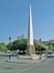
Monumento a la abolición de la esclavitud
 Image of the monument with the statue at its base | |
| Coordinates | 18° 0' 20.6274" & -66° 36' 45.9354" |
|---|---|
| Location | Barrio Tercero, Ponce, Puerto Rico |
| Designer |
Statue: Victor Colt Obelisk: City of Ponce |
| Type |
Obelisk on Pedestal Statue on Pedestal |
| Material |
Marble (obelisk) Iron (statue) |
| Height | 100 feet |
| Beginning date | 1956 |
| Completion date | 1956 |
| Opening date | 1956[1] |
| Dedicated to | The Abolition of Slavery in Puerto Rico |
The Monumento a la abolición de la esclavitud (Monument to the abolition of slavery) is a monument in Barrio Tercero in Ponce, Puerto Rico, dedicated to the abolition of slavery in Puerto Rico in 1873. It is the only monument in the Caribbean dedicated as a remembrance to the abolition of slavery.
Location
The monument is located on Avenida Hostos at the fork of Salud Street and Marina Street. It is the centerpiece of Parque de la Abolicion and it is located on its grounds, at the park's southern edge. The monument consists of two main pieces, an obelisk and a statue. The statue is that of a black male slave with broken chains depicting he is now a free man. It coordinates are 18.00573, -66.61276.
Properties and features
The 100-foot high obelisk raises just behind the black iron sculpture of the freed slave that accentuates and gives instance to the occasion. The monument and obelisk are surrounded by graceful gardens. Immediately north of the obelisk is the outdoors acoustic amphitheater known as La Concha Acústica (English: The Acoustic Shell) which completes the park as a triangular city block. La Concha Acústica is an open-air auditorium oftentimes used as a music venue, including presentations by the Ponce Municipal Band.[2]
History
Slaves were brought to Puerto Rico from Africa from 1513 and through the 18th century to replace the local native "Indian" slaves who had been decimated.[3] The new slaves worked the coffee, sugar cane, and gold mining industries in Puerto Rico. During the 18th century, as gold mining ceased to be one of the major industries in Puerto Rico, slaves worked mostly in coffee plantations and sugar cane fields. By royal proclamation slavery was abolished on 22 March 1873.
Construction
In 1874, a year after the abolition of slavery in Puerto Rico, a group of citizens built a small park in memory of the historic event. In 1880 Olimpio Otero, Juan Mayoral Barnés, and Román Baldorioty de Castro were instrumental in creating the concept for a park dedicated to the commemorating the abolition of slavery, the only such memorial in the Caribbean.[4] Juan Mayoral Barnés brought the idea for the creation of the park to the Ponce Municipal Assembly on 14 March 1880. It was unanimously approved by the Assembly, ratified by the Central Government, and confirmed by Royal Decree on 1 March 1881.[5] The park was built in the 1890s and, in 1956, under the administration of Ponce mayor Andrés Grillasca Salas, the statue piece of the monument was placed at the base of the obelisk.[6] The sculpture of the freed slave is a work of Victor Colt.[7] The obelisk is built in marble and has a metal tip.
References
- ↑ Ponce: Informacion para estudiantes. Government of the Autonomous Municipality of Ponce. Ponce, Puerto Rico. Retrieved 24 April 2013.
- ↑ Explore Puerto Rico. Harry S. Pariser. San Francisco: Manatee Press. Page 244. Retrieved 24 April 2013.
- ↑ "Puerto Rico | Colonial Genocides | Genocide Studies Program". Yale University. Retrieved 2013-04-24.
- ↑ Parque de la Abolición - Commemorating the End of an Era. NewMedia Holdings, Inc. Retrieved 24 April 2013.
- ↑ Verdadera y Autentica Historia de la Ciudad de Ponce. By Dr. Eduardo Neumann. 1913. (In Spanish) Reprinted by the Instituto de Cultura Puertorriqueña (1987). Pages 99-100.
- ↑ Parque y Obelisco de la abolición de la esclavitud y concha acústica. Ponce, Ciudad Señorial: Walking Tour. Government of the Autonomous Municipality of Ponce. Retrieved 24 April 2013.
- ↑ Tourist Attractions: Enjoy Ponce, Southern Experience. Autonomous Municipality of Ponce. Office of Tourism Development. August 2010.
See also
Coordinates: 18°00′20.6274″N 66°36′45.9354″W / 18.005729833°N 66.612759833°W