Concha Acústica de Ponce
|
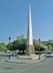
Concha Acústica de Ponce, seen from behind the stage | |
| Former names | Parque de la Abolición (1956-1962) |
|---|---|
| Address | Marina and Salud Streets |
| Location | Ponce, Puerto Rico |
| Coordinates | 18° 00' 22.78"N; 66° 36' 45.79"W |
| Owner | Municipality of Ponce |
| Type | Amphitheatre |
| Seating type | Concrete benches; lawn area |
| Capacity | 2,000[1] |
| Construction | |
| Built | 1880s |
| Opened | 1890s |
| Renovated | 1956[2] |
Concha Acústica de Ponce (English: Ponce Acoustic Shell) is an open-air music and performing arts amphitheater venue in Ponce, Puerto Rico. It is located on the same block as Parque de la Abolición. Concha Acústica was built in 1956 together with the adjacent Monumento a la abolición de la esclavitud.[3]
Location and features
The amphiteater is located on Avenida Hostos at the fork of Salud Street and Marina Street. It is immediately north of the obelisk commemorating the abolition of slavery, Monumento a la abolición de la exclavitud. Together with the obelisk, Concha Acústica which completes the park as a triangular city block. The amphitheater can seat 2,000 people.[4] Seats in the audience portion of the amphitheater consist of long concrete benches capable of seating several families each.
History
In 1874, a year after the abolition of slavery, a group of citizens built a small monument in memory of the historic event. In 1880 Olimpio Otero, Juan Mayoral Barnés, and Román Baldorioty de Castro were instrumental in formalizing the concept for a park dedicated to the commemorating the abolition of slavery in Puerto Rico.[5] Juan Mayoral Barnés brought the idea for the creation of the park to the Ponce Municipal Assembly on 14 March 1880. It was unanimously approved by the Assembly, ratified by the Central Government, and confirmed by Royal Decree on 1 March 1881.[6]
Venue creation
The park was built in the 1890s.[7] Concha Acústica was built in 1956 under the administration of Andrés Grillasca Salas on the same space occupied by the existing park.[8] The 1956 architect in charge was Francisco Porrata Doria, an architect from Ponce.[9]
Uses
Concha Acústica has seen numerous uses throughout the years. On a regular basis, the open-air auditorium is also used for presentations by the Ponce Municipal Band[10] and the Ponce Jazz Festival.[11]
See also
Further reading
- Ni la lluvia frenó al Ponce Jazz Fest. (By Reinaldo Millán. La Perla del Sur. Ponce, Puerto Rico. Year 30, Issue 1535. Page 26. 1 May 2013. Retrieved 1 May 2013.), photo of the Concha Acústica and its amphitheater sections of Abolition Park.
- Ni la lluvia frenó al Ponce Jazz Fest. Reinaldo Millán. La Perla del Sur. Ponce, Puerto Rico. Year 30, Issue 1535. Page 26. 1 May 2013. Accessed 2 June 2016. (Photo of the Concha Acústica and its amphitheater sections of Abolition Park.)
External links
- See closeup photo of Concha Acustica Here
- Photo of Parque de la Abolicion (ca. 1906) before the obelisk was built
References
- ↑ Explore Puerto Rico. By Harry S. Pariser. San Francisco: Manatee Press. Page 244. Retrieved 13 September 2013.
- ↑ Ponce: Informacion para estudiantes. Government of the Autonomous Municipality of Ponce. Ponce, Puerto Rico. Retrieved 14 December 2011.
- ↑ Informacion sobre Ponce - Para Estudiantes. Ponce Municipal Government. Retrieved 1 April 2014.
- ↑ Explore Puerto Rico. By Harry S. Pariser. San Francisco: Manatee Press. Page 244. Retrieved November 30, 2009.
- ↑ Parque de la Abolición - Commemorating the End of an Era. NewMedia Holdings, Inc. Retrieved 26 February 2012.
- ↑ Verdadera y Autentica Historia de la Ciudad de Ponce. By Dr. Eduardo Neumann. 1913. (In Spanish) Reprinted by the Instituto de Cultura Puertorriqueña (1987). Pages 99-100.
- ↑ Parque y Obelisco de la abolición de la esclavitud y concha acústica. Ponce, Ciudad Señorial: Walking Tour. Government of the Autonomous Municipality of Ponce. Retrieved 26 February 2012.
- ↑ Parque y Obelisco de la abolición de la esclavitud y concha acústica. Ponce, Ciudad Señorial: Walking Tour. Government of the Autonomous Municipality of Ponce. Retrieved 26 February 2012.
- ↑ Tourist Attractions: Enjoy Ponce, Southern Experience. Brochure. Autonomous Municipality of Ponce. Office of Tourism Development. August 2010.
- ↑ Actividades Semana de la Danza 2007 (Domingo 20 de Mayo): Concurso de Baile de Danzas 2007, Concha Acústica del Parque de Abolición de la Esclavitud, Ponce, Puerto Rico. El Hogar de la Danza Puertorriqueña. 2016. Accessed 2 June 2016.
- ↑ Arranca este viernes Ponce Jazz Fest. Carmen Cila Rodríguez. La Perla del Sur. Ponce, Puerto Rico. Year 30, Issue 1482. Page 26. 1 May 2013. Accessed 2 June 2016.
Coordinates: 18°00′22.7874″N 66°36′45.7914″W / 18.006329833°N 66.612719833°W