Moose Lake (Alberta)
| Moose Lake | |
|---|---|
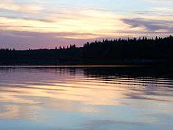 Sunset in Franchere Bay | |
| Location | Bonnyville No. 87, Alberta |
| Coordinates | 54°15′04″N 110°54′25″W / 54.25111°N 110.90694°WCoordinates: 54°15′04″N 110°54′25″W / 54.25111°N 110.90694°W |
| Type | eutrophic |
| Primary inflows | Thinlake River |
| Primary outflows | Mooselake River |
| Catchment area | 755 km2 (292 sq mi) |
| Basin countries | Canada |
| Max. length | 14 km (8.7 mi) |
| Max. width | 4.4 km (2.7 mi) |
| Surface area | 40.8 km2 (15.8 sq mi) |
| Average depth | 5.6 m (18 ft)[1] |
| Max. depth | 19.8 m (65 ft) |
| Residence time | 7.5 years |
| Surface elevation | 530 m (1,740 ft) |
| Settlements | Bonnyville |
Moose Lake is a relatively small lake in North-eastern Alberta, Canada, which drains north into the Beaver River (Canada). It is located just a few kilometres west of the town of Bonnyville.
It is unclear whether the name (translated from the French: Lac d'Orignal) was given because of the large moose population of the area or because the shape of the lake resembles a moose's head - Franchere Bay and Vezeau Bay being the antlers, Bonnyville Beach the chin, and Island Bay the nose (complete with a large island for a nostril).
Around 1768 William Pink passed the mouth of the Mooselake River. In 1789 Angus Shaw of the North West Company built a post on the northwest shore of the lake called Fort Lac L'Orignal or Shaw House. It was on the northwest side on a large point southeast of the lake's outlet. The river was so shallow that canoes were taken up the river empty and goods portaged overland. It was in good beaver country and within easy reach of Fort George 35 miles to the south on the North Saskatchewan. Buffalo pemmican was carried north to the lake and then via the Beaver River to Lac Île-à-la-Crosse to feed the voyageurs on their long journey to Lake Athabasca. In the 1792-93 season Moose Lake produced 64 of the 392 total packs of beaver produced by the Churchill River Department. In 1798 David Thompson (explorer) reached the lake from Fort George.
Geography
The major inflow is the Thinlake River, which enters the westernmost point of the lake in Franchere Bay, and the major outflow is the Mooselake River which exits the lake through the northern shore of Franchere Bay.[1] Moose Lake Provincial Park straddles the point separating Franchere Bay and Vezeau Bay and its western edge is the Mooselake River.[2] Most of the shoreline development is on the eastern shores of Vezeau Bay and Bonnyville Beach, comprising several unincorporated communities including Pelican Narrows. There are several Christian summer camps on Franchere Bay, including a Baptist, Pentecostal, and a Roman Catholic camp on the North shore and a Ukrainian Orthodox camp on the South shore.
Fishing
The lake supports some commercial fishing and recreational fishing is also popular. Sport fish in Moose Lake include Northern Pike, Lake Whitefish, Walleye, and Perch. There is a yearly Walleye tournament in the lake that speaks to the abundance of recreational fishing.
References
- 1 2 Atlas of Alberta Lakes. Moose Lake
- ↑ Alberta Tourism. Moose Lake Provincial Park