Mount Davis (Pennsylvania)
| Mount Davis | |
|---|---|
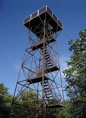 Observation tower atop Mt. Davis, Pennsylvania | |
| Highest point | |
| Elevation | 3,213 ft (979 m) [1] |
| Prominence | 653 ft (199 m) [1] |
| Listing | U.S. state high point 33rd |
| Coordinates | 39°47′10″N 79°10′33″W / 39.7861908°N 79.1758631°WCoordinates: 39°47′10″N 79°10′33″W / 39.7861908°N 79.1758631°W [2] |
| Geography | |
 Mount Davis | |
| Parent range | Allegheny Mountains |
| Topo map | USGS Markleton and Meyersdale |
| Climbing | |
| Easiest route | Paved road leads almost directly to the summit, with a very short trail the rest of the way. |
Mount Davis (3,213 ft or 979 m) is the highest point in Pennsylvania. Located in the 5,685 acres (2,301 ha) Forbes State Forest near the hamlet of Markleton in Elk Lick Township, Somerset County, it lies on a gentle crest of a 30-mile (50 km) ridge line extending from central Somerset County southward into Garrett County, Maryland known as Negro Mountain.
The high point was named for John Nelson Davis, an early settler, American Civil War veteran, surveyor, and naturalist known for his studies of the mountain's flora and fauna. During the Civil War, Davis served in Company E, 102nd Pennsylvania Infantry.[3]
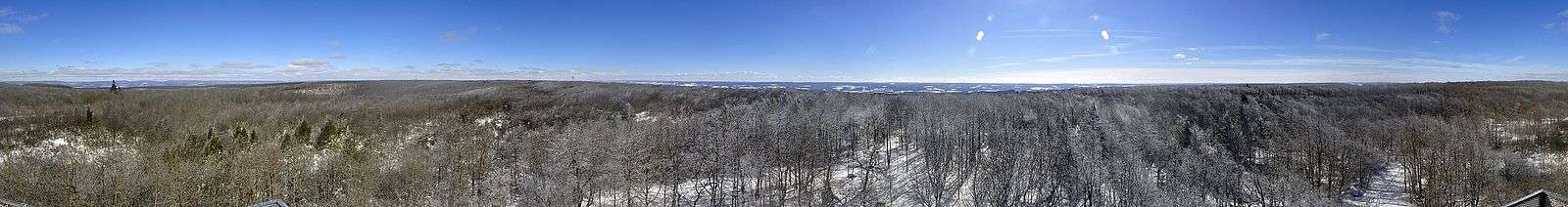
The summit of Mt. Davis may be ascended by car or a number of hiking trails. Its surrounds are noted for their patterns of unusual circular stone formed by periglacial action. A metal observation tower with a relief map of the region stands near the true high point. Mount Davis ranks 33rd on the list of highest natural points in each U.S. state.[4]
History
In 1921 the USGS established that Mount Davis (3,213 ft or 979 m) was the highest peak in Pennsylvania. Previously the highest peak was believed to be Bedford County's Blue Knob. On June 18, 1921 the local chamber of commerce held a ceremony to celebrate the newly named highest point in Pennsylvania.
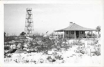
In addition to the observation tower a cabin once stood at the top of Mount Davis as seen in the photo below (circa 1939). The summit is identified by the arrow in the picture.
Trails
Trails in the park include:[5]
- High Point Trail: 0.8 miles (1.3 km)
- Mt. Davis Trail: 0.1 miles (0.2 km)
- Shelter Rock Trail: 1 mile (1.6 km)
- Tub Mill Run Trail: 2.8 miles (4.5 km)
- Timberslide Trail: 0.5 miles (0.8 km)
- Laurel Run Trail: 1.9 miles (3.1 km)
- Wolf Rock Trail: 0.8 miles (1.3 km)
- Shelter Rock Road: 1.6 miles (2.6 km)
- Livengood Trail: 1.1 miles (1.8 km)
 Beginning of Tub Mill Run Trail
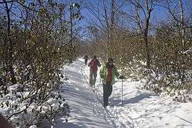 Cross country skiing on Tub Mill Run Trail
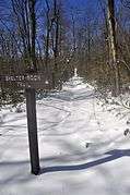 Beginning of Shelter Rock Trail
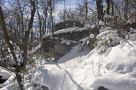 Shelter Rock along Shelter Rock Trail
 Forest in the winter
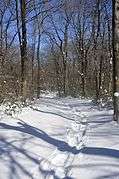
Climate
Climate on the peak is warm in the summer, and cold in the winter. Like much of Pennsylvania, Mount Davis can experience heavy winds, rain, and hail in the summer, with ice storms and blizzards in the winter. Temperature extremes range from −33 to 84 °F (−36 to 29 °C), though frosts have been recorded in every month of the year. Summer conditions are generally mild and winters are characterized by a lot of snowfall. Average annual precipitation ranges from 38 to 42 inches (970 to 1,070 mm).
Mount Davis has a humid continental climate that is affected by the high elevation significantly enough that the area feels slightly more like a cooler version of the climate zone during the winter months. Due to its high elevation, the area is colder much of the winter than Altoona, Johnstown, or State College, despite being well south of those locations. During the summer months, the area is a retreat for other Pennsylvanians with high temperatures averaging around 15 degrees cooler than Pittsburgh and eastern portions of the state. Mount Davis recorded many impressive record lows and is quite close to the state's all-time coldest temperature.
| Climate data for Mount Davis, Pennsylvania | |||||||||||||
|---|---|---|---|---|---|---|---|---|---|---|---|---|---|
| Month | Jan | Feb | Mar | Apr | May | Jun | Jul | Aug | Sep | Oct | Nov | Dec | Year |
| Record high °F (°C) | 59 (15) |
66 (19) |
69 (21) |
75 (24) |
79 (26) |
84 (29) |
86 (30) |
83 (28) |
79 (26) |
67 (19) |
64 (18) |
60 (16) |
86 (30) |
| Average high °F (°C) | 26 (−3) |
29 (−2) |
35 (2) |
49 (9) |
60 (16) |
68 (20) |
74 (23) |
74 (23) |
65 (18) |
53 (12) |
41 (5) |
30 (−1) |
49 (9) |
| Average low °F (°C) | 7 (−14) |
10 (−12) |
17 (−8) |
25 (−4) |
34 (1) |
44 (7) |
55 (13) |
51 (11) |
44 (7) |
29 (−2) |
24 (−4) |
13 (−11) |
35 (2) |
| Record low °F (°C) | −38 (−39) |
−31 (−35) |
−24 (−31) |
−5 (−21) |
12 (−11) |
19 (−7) |
32 (0) |
30 (−1) |
22 (−6) |
7 (−14) |
−12 (−24) |
−24 (−31) |
−38 (−39) |
| Average precipitation inches (mm) | 3.7 (94) |
3.3 (84) |
3.5 (89) |
3.8 (97) |
4.3 (109) |
4.5 (114) |
5.0 (127) |
4.8 (122) |
4.4 (112) |
3.1 (79) |
4.6 (117) |
5.1 (130) |
50.1 (1,273) |
| Average snowfall inches (cm) | 44.3 (112.5) |
27.8 (70.6) |
25.7 (65.3) |
10.8 (27.4) |
3.2 (8.1) |
Trace | 0 (0) |
0 (0) |
0 (0) |
2.1 (5.3) |
13.1 (33.3) |
23.1 (58.7) |
151.1 (383.8) |
| Source: [6] | |||||||||||||
See also
References
- 1 2 "Mount Davis". Peakbagger.com. Retrieved 2009-01-30.
- ↑ "Mount Davis". Geographic Names Information System. United States Geological Survey. Retrieved 2009-01-30.
- ↑ nps.gov/civilwar. "Civil War National Park Service". Retrieved 2013-04-07.
- ↑ "Map and List of U.S. State Highpoints". The Peak Seeker. Retrieved 2016-02-16.
- ↑ "Mount Davis". SummitPost.org. Retrieved 2009-01-30.
- ↑ "Seven Springs Mountain Resort". The Weather Channel. Retrieved 2012-11-10.