Mount Sunflower
| Mount Sunflower | |
|---|---|
 The "summit" of Mount Sunflower | |
| Highest point | |
| Elevation | 4,039 ft (1,231 m) [1] |
| Prominence | 19 ft (5.8 m) [2] |
| Listing | U.S. state high point 28th |
| Coordinates | 39°01′19″N 102°02′14″W / 39.02194°N 102.03722°WCoordinates: 39°01′19″N 102°02′14″W / 39.02194°N 102.03722°W [1] |
| Geography | |
 Mount Sunflower Kansas | |
| Location | Wallace County, Kansas, US |
| Topo map | USGS Mount Sunflower |
| Climbing | |
| Easiest route | Drive |
Mount Sunflower is the highest natural point in the state of Kansas.[1] At 4,039 feet (1,231 m), it is 3,300 feet (1,010 m) above the state's topographic low point in southeastern Kansas. Located in Wallace County, it is less than half a mile (0.8 km) from the Colorado state border and close to the lowest point in Colorado.
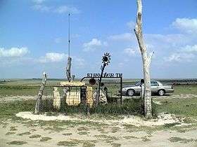
Mount Sunflower is located on private land owned by Ed and Cindy Harold, who encourage visitors to the site. Amenities include a picnic table, a little free library, a sunflower sculpture made from railroad spikes, and a plaque on the site stated, "On this site in 1897, nothing happened." As of 2015, however, that sign is missing, evidently stolen. Additionally, there is a mailbox on site with a registration book inside where you can write your name, where you are from, and how many in your party.
Access is via county dirt roads to the edge of the property, then across a cattle guard and onto a private dirt road through a cattle grazing pasture to the summit.
The state of Kansas gradually increases in elevation from the east to the west. As such, "Mount" Sunflower, while the highest point in the state in terms of elevation, is virtually indistinguishable from the surrounding terrain.
See also
References
- 1 2 3 "Mount Sunflower". Geographic Names Information System. United States Geological Survey. Retrieved 2008-12-21.
- ↑ "Mount Sunflower, Kansas". Peakbagger.com. Retrieved 2008-12-21.
External links
- "Mount Sunflower". SummitPost.org. Retrieved 2008-12-21.
- "Mount Sunflower". ListsOfJohn.com. Retrieved 2012-11-08.
- "Mount Sunflower". KansasTravel.org. Retrieved 2012-11-08.
- "Mount Sunflower". Peakery.com. Retrieved 2012-11-08.