Inkerman, Queensland
| Inkerman Queensland | |||||||||||||
|---|---|---|---|---|---|---|---|---|---|---|---|---|---|
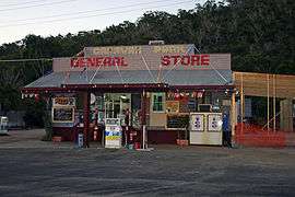
 Caravan Park General Store, 2010. | |||||||||||||
 Inkerman | |||||||||||||
| Coordinates | 19°42′S 147°26′E / 19.700°S 147.433°ECoordinates: 19°42′S 147°26′E / 19.700°S 147.433°E | ||||||||||||
| Population | 364 (2011 census)[1] | ||||||||||||
| Postcode(s) | 4806 | ||||||||||||
| Location |
| ||||||||||||
| LGA(s) | Burdekin Shire Council | ||||||||||||
| State electorate(s) | Burdekin | ||||||||||||
| Federal Division(s) | Dawson | ||||||||||||
| |||||||||||||
Inkerman is a town and locality in the Shire of Burdekin in North Queensland, Australia.[2][3] In the 2011 census, Inkerman had a population of 364 people.[1]
Geography
Inkerman bounded on the west by the Bruce Highway and the North Coast railway line. It is well known for Mount Inkerman in the south of the locality, rising to 210 metres above the otherwise flat land of Inkerman (almost at sea level) with a road to the lookout and picnic facilities at the top.[4][5]
History
Inkerman Post Office opened by 1915 as a receiving office (known for a time as Inkerman Siding) and closed in 1975.[6]
Inkerman State School opened on 24 November 1915. It closed on 31 December 1974.[7]
At the 2006 census, Inkerman had a population of 520.[8]
Heritage listings
Inkerman has a number of heritage-listed sites, including:
- Off Charlie's Hill Road: Radar Station, Charlie's Hill[9]
Notes and references
- 1 2 Australian Bureau of Statistics (31 October 2012). "Inkerman". 2011 Census QuickStats. Retrieved 14 January 2016.
- ↑ "Inkerman - town (entry 16707)". Queensland Place Names. Queensland Government. Retrieved 14 January 2016.
- ↑ "Inkerman - locality (entry 49586)". Queensland Place Names. Queensland Government. Retrieved 14 January 2016.
- ↑ "Queensland Globe". State of Queensland. Retrieved 14 January 2016.
- ↑ "Mt Inkerman lookout to get a facelift". Burdekin Shire Council. Retrieved 2016-01-14.
- ↑ Premier Postal History. "Post Office List". Premier Postal Auctions. Retrieved 10 May 2014.
- ↑ "Opening and closing dates of Queensland Schools". Queensland Government. Retrieved 14 January 2016.
- ↑ Australian Bureau of Statistics (25 October 2007). "Inkerman (Burdekin Shire) (State Suburb)". 2006 Census QuickStats. Retrieved 29 May 2011.
- ↑ "Radar Station, Charlie's Hill (entry 601716)". Queensland Heritage Register. Queensland Heritage Council. Retrieved 7 July 2013.
External links
![]() Media related to Inkerman, Queensland at Wikimedia Commons
Media related to Inkerman, Queensland at Wikimedia Commons