Mount Oizuru
| Mount Oizuru | |
|---|---|
| 笈ヶ岳 | |
 Mount Oizuru | |
| Highest point | |
| Elevation | 1,841 m (6,040 ft) |
| Coordinates | 36°17′55″N 136°47′32″E / 36.29861°N 136.79222°ECoordinates: 36°17′55″N 136°47′32″E / 36.29861°N 136.79222°E |
| Geography | |
 Mount Oizuru Location in Japan | |
| Location |
Gifu Prefecture Ishikawa Prefecture Toyama Prefecture Japan |
| Parent range | Ryōhaku Mountains |
| Topo map | Geographical Survey Institute, 25000:1 白山, 50000:1 白山 |
| Climbing | |
| First ascent | Prior to 1518 |
Mount Oizuru (笈ヶ岳 Oizuru-ga-take) is located on the borders of Gifu, Ishikawa and Toyama prefectures in Japan. It is in the northern area of Hakusan National Park and is part of the Ryōhaku Mountains.
Geography
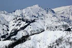
Mount Oizuru, at 1,841 m (6,040 ft), is the tallest mountain in the northern part of the Ryōhaku Mountains. Just north of the mountain is Mount Ōgasa (大笠山 Ōgasa-yama), which is slightly shorter at 1,821 m (5,974 ft). There are three triangulation stations on the mountain's thin peak.
History
Taichō is said to have first scaled the mountain in the early eighth century.
Gallery
 Mount Oizuru seen from Mount Mae-Oizuru |
 Mount Oizuru seen from Mount Senniniwaya |
 Mount Oizuru and Mount Ōgasa seen from Mount Sanpōiwa |
References
See also
| Wikimedia Commons has media related to Mount Oizuru. |
This article is issued from Wikipedia - version of the 2/6/2016. The text is available under the Creative Commons Attribution/Share Alike but additional terms may apply for the media files.